- ডেটাসেটের প্রাপ্যতা
- 2000-03-03T00:00:00Z–2026-06-01T00:00:00Z
- ডেটাসেট প্রযোজক
- USGS EROS সেন্টারে NASA LP DAAC
- ক্যাডেন্স
- ১ দিন
- ট্যাগ
বর্ণনা
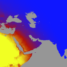
MCD18A1 সংস্করণ ৬.২ হলো একটি মডারেট রেজোলিউশন ইমেজিং স্পেকট্রোরেডিওমিটার (MODIS) টেরা এবং অ্যাকোয়া সম্মিলিত ডাউনওয়ার্ড শর্টওয়েভ রেডিয়েশন (DSR) গ্রিডেড লেভেল ৩ প্রোডাক্ট, যা প্রতিদিন ১ কিলোমিটার পিক্সেল রেজোলিউশনে উৎপাদিত হয় এবং প্রতি ৩ ঘণ্টা অন্তর DSR-এর আনুমানিক মান প্রদান করে। DSR হলো শর্টওয়েভ স্পেকট্রামে (৩০০-৪,০০০ ন্যানোমিটার) ভূমির উপর আপতিত সৌর বিকিরণ এবং এটি ভূমি-পৃষ্ঠ মডেলের একটি গুরুত্বপূর্ণ চলক, যা বিভিন্ন বৈজ্ঞানিক ও প্রয়োগমূলক বিষয় নিয়ে কাজ করে। MCD18 প্রোডাক্টগুলো একটি প্রোটোটাইপিং অ্যালগরিদমের উপর ভিত্তি করে তৈরি, যা MODIS ডেটার মাল্টি-টেম্পোরাল সিগনেচার ব্যবহার করে ভূপৃষ্ঠের প্রতিফলন ক্ষমতা নির্ণয় করে এবং তারপর লুক-আপ টেবিল (LUT) পদ্ধতির মাধ্যমে আপতিত DSR গণনা করে। LUT-গুলো বিভিন্ন আলোকসজ্জা/দর্শন জ্যামিতিতে অ্যারোসল এবং মেঘের বিভিন্ন ধরনের লোডিং বিবেচনা করে। বৈশ্বিক DSR প্রোডাক্টগুলো MODIS এবং ভূস্থির উপগ্রহের ডেটা থেকে তৈরি করা হয়। ডেটা তৈরির জন্য ব্যবহৃত পদ্ধতি সম্পর্কে অতিরিক্ত বিবরণ অ্যালগরিদম থিওরিটিক্যাল বেসিস ডকুমেন্ট- এ পাওয়া যাবে।
ব্যান্ড
ব্যান্ড
পিক্সেল সাইজ: ১০০০ মিটার (সকল ব্যান্ড)
| নাম | ইউনিট | মিনিট | ম্যাক্স | পিক্সেল আকার | বর্ণনা | ||||||||||||||||||||||||||||||||||||||||||||||||||||||||||||||||||||||||||||||||||||||||||||||
|---|---|---|---|---|---|---|---|---|---|---|---|---|---|---|---|---|---|---|---|---|---|---|---|---|---|---|---|---|---|---|---|---|---|---|---|---|---|---|---|---|---|---|---|---|---|---|---|---|---|---|---|---|---|---|---|---|---|---|---|---|---|---|---|---|---|---|---|---|---|---|---|---|---|---|---|---|---|---|---|---|---|---|---|---|---|---|---|---|---|---|---|---|---|---|---|---|---|---|---|
DSR | ওয়াট/বর্গমিটার | ০ | ১৪০০ | ১০০০ মিটার | মোডিস ওভারপাসে তাৎক্ষণিক মোট ডিএসআর | ||||||||||||||||||||||||||||||||||||||||||||||||||||||||||||||||||||||||||||||||||||||||||||||
Direct | ওয়াট/বর্গমিটার | ০ | ১৪০০ | ১০০০ মিটার | মোডিস ওভারপাসে তাৎক্ষণিক সরাসরি ডিএসআর | ||||||||||||||||||||||||||||||||||||||||||||||||||||||||||||||||||||||||||||||||||||||||||||||
Diffuse | ওয়াট/বর্গমিটার | ০ | ১৪০০ | ১০০০ মিটার | MODIS ওভারপাসে তাৎক্ষণিক ডিফিউজ DSR | ||||||||||||||||||||||||||||||||||||||||||||||||||||||||||||||||||||||||||||||||||||||||||||||
GMT_0000_DSR | ওয়াট/বর্গমিটার | ০ | ১৪০০ | ১০০০ মিটার | জিএমটি ০০:০০ এ মোট ডিএসআর | ||||||||||||||||||||||||||||||||||||||||||||||||||||||||||||||||||||||||||||||||||||||||||||||
GMT_0300_DSR | ওয়াট/বর্গমিটার | ০ | ১৪০০ | ১০০০ মিটার | জিএমটি ০৩:০০ এ মোট ডিএসআর | ||||||||||||||||||||||||||||||||||||||||||||||||||||||||||||||||||||||||||||||||||||||||||||||
GMT_0600_DSR | ওয়াট/বর্গমিটার | ০ | ১৪০০ | ১০০০ মিটার | জিএমটি ০৬:০০ এ মোট ডিএসআর | ||||||||||||||||||||||||||||||||||||||||||||||||||||||||||||||||||||||||||||||||||||||||||||||
GMT_0900_DSR | ওয়াট/বর্গমিটার | ০ | ১৪০০ | ১০০০ মিটার | জিএমটি ০৯:০০ এ মোট ডিএসআর | ||||||||||||||||||||||||||||||||||||||||||||||||||||||||||||||||||||||||||||||||||||||||||||||
GMT_1200_DSR | ওয়াট/বর্গমিটার | ০ | ১৪০০ | ১০০০ মিটার | জিএমটি ১২:০০ এ মোট ডিএসআর | ||||||||||||||||||||||||||||||||||||||||||||||||||||||||||||||||||||||||||||||||||||||||||||||
GMT_1500_DSR | ওয়াট/বর্গমিটার | ০ | ১৪০০ | ১০০০ মিটার | জিএমটি ১৫:০০ এ মোট ডিএসআর | ||||||||||||||||||||||||||||||||||||||||||||||||||||||||||||||||||||||||||||||||||||||||||||||
GMT_1800_DSR | ওয়াট/বর্গমিটার | ০ | ১৪০০ | ১০০০ মিটার | জিএমটি ১৮:০০ এ মোট ডিএসআর | ||||||||||||||||||||||||||||||||||||||||||||||||||||||||||||||||||||||||||||||||||||||||||||||
GMT_2100_DSR | ওয়াট/বর্গমিটার | ০ | ১৪০০ | ১০০০ মিটার | জিএমটি ২১:০০ এ মোট ডিএসআর | ||||||||||||||||||||||||||||||||||||||||||||||||||||||||||||||||||||||||||||||||||||||||||||||
DSR_Quality | ১০০০ মিটার | গুণমানের পতাকা | |||||||||||||||||||||||||||||||||||||||||||||||||||||||||||||||||||||||||||||||||||||||||||||||||
ব্যবহারের শর্তাবলী
ব্যবহারের শর্তাবলী
LP DAAC-এর মাধ্যমে অর্জিত MODIS ডেটা এবং প্রোডাক্টের পরবর্তী ব্যবহার, বিক্রয় বা পুনঃবণ্টনের উপর কোনো বিধিনিষেধ নেই।
উদ্ধৃতি
DOI
আর্থ ইঞ্জিন দিয়ে অন্বেষণ করুন
কোড এডিটর (জাভাস্ক্রিপ্ট)
var dataset = ee.ImageCollection('MODIS/062/MCD18A1')
                  .filter(ee.Filter.date('2000-01-01', '2001-01-01'));
var gmt_1200_dsr = dataset.select('GMT_1200_DSR');
var gmt_1200_dsr_vis = {
  min: 0,
  max: 350,
  palette: ['0f17ff', 'b11406', 'f1ff23'],
};
Map.setCenter(6.746, 46.529, 2);
Map.addLayer(
    gmt_1200_dsr, gmt_1200_dsr_vis,
    'Total dsr at GMT 12:00');