- Dostępność zbioru danych
- 2000-03-03T00:00:00Z–2026-06-01T00:00:00Z
- Twórca zbioru danych
- Ośrodek NASA LP DAAC w USGS EROS Center
- Częstotliwość
- 1 dzień
- Tagi
Opis
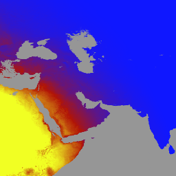
MCD18A1 w wersji 6.2 to połączony produkt poziomu 3 z siatką, który zawiera dane o krótkofalowym promieniowaniu słonecznym (DSR) z instrumentów MODIS (Moderate Resolution Imaging Spectroradiometer) na satelitach Terra i Aqua. Jest on tworzony codziennie w rozdzielczości 1 km na piksel i zawiera szacunki DSR co 3 godziny. DSR to promieniowanie słoneczne padające na powierzchnię lądu w widmie krótkofalowym (300–4000 nanometrów). Jest to ważna zmienna w modelach powierzchni lądu,które uwzględniają różne kwestie naukowe i praktyczne. Produkty MCD18 są oparte na algorytmie prototypowym, który wykorzystuje sygnatury wieloczasowe danych MODIS do uzyskania współczynnika odbicia powierzchni, a następnie oblicza padające DSR za pomocą tabeli LUT. Tabele LUT uwzględniają różne rodzaje obciążeń aerozoli i chmur przy różnych geometriach oświetlenia i obserwacji. Globalne produkty DSR są generowane na podstawie danych z satelitów MODIS i geostacjonarnych. Dodatkowe informacje o metodologii użytej do utworzenia danych są dostępne w dokumencie Algorithm Theoretical Basis Document.
Pasma
Pasma
Rozmiar piksela: 1000 metrów (wszystkie pasma)
| Nazwa | Jednostki | Min. | Maks. | Rozmiar piksela | Opis | ||||||||||||||||||||||||||||||||||||||||||||||||||||||||||||||||||||||||||||||||||||||||||||||
|---|---|---|---|---|---|---|---|---|---|---|---|---|---|---|---|---|---|---|---|---|---|---|---|---|---|---|---|---|---|---|---|---|---|---|---|---|---|---|---|---|---|---|---|---|---|---|---|---|---|---|---|---|---|---|---|---|---|---|---|---|---|---|---|---|---|---|---|---|---|---|---|---|---|---|---|---|---|---|---|---|---|---|---|---|---|---|---|---|---|---|---|---|---|---|---|---|---|---|---|
DSR |
W/m^2 | 0 | 1400 | 1000 metrów | Chwilowe całkowite DSR w momencie przelotu MODIS |
||||||||||||||||||||||||||||||||||||||||||||||||||||||||||||||||||||||||||||||||||||||||||||||
Direct |
W/m^2 | 0 | 1400 | 1000 metrów | Chwilowe bezpośrednie DSR w momencie przelotu MODIS |
||||||||||||||||||||||||||||||||||||||||||||||||||||||||||||||||||||||||||||||||||||||||||||||
Diffuse |
W/m^2 | 0 | 1400 | 1000 metrów | Chwilowe rozproszone DSR w momencie przelotu MODIS |
||||||||||||||||||||||||||||||||||||||||||||||||||||||||||||||||||||||||||||||||||||||||||||||
GMT_0000_DSR |
W/m^2 | 0 | 1400 | 1000 metrów | Całkowite DSR o godzinie 00:00 GMT |
||||||||||||||||||||||||||||||||||||||||||||||||||||||||||||||||||||||||||||||||||||||||||||||
GMT_0300_DSR |
W/m^2 | 0 | 1400 | 1000 metrów | Całkowite DSR o godzinie 03:00 GMT |
||||||||||||||||||||||||||||||||||||||||||||||||||||||||||||||||||||||||||||||||||||||||||||||
GMT_0600_DSR |
W/m^2 | 0 | 1400 | 1000 metrów | Całkowite DSR o godzinie 06:00 GMT |
||||||||||||||||||||||||||||||||||||||||||||||||||||||||||||||||||||||||||||||||||||||||||||||
GMT_0900_DSR |
W/m^2 | 0 | 1400 | 1000 metrów | Całkowite DSR o godzinie 09:00 GMT |
||||||||||||||||||||||||||||||||||||||||||||||||||||||||||||||||||||||||||||||||||||||||||||||
GMT_1200_DSR |
W/m^2 | 0 | 1400 | 1000 metrów | Całkowite DSR o godzinie 12:00 GMT |
||||||||||||||||||||||||||||||||||||||||||||||||||||||||||||||||||||||||||||||||||||||||||||||
GMT_1500_DSR |
W/m^2 | 0 | 1400 | 1000 metrów | Całkowite DSR o godzinie 15:00 GMT |
||||||||||||||||||||||||||||||||||||||||||||||||||||||||||||||||||||||||||||||||||||||||||||||
GMT_1800_DSR |
W/m^2 | 0 | 1400 | 1000 metrów | Całkowite DSR o godzinie 18:00 GMT |
||||||||||||||||||||||||||||||||||||||||||||||||||||||||||||||||||||||||||||||||||||||||||||||
GMT_2100_DSR |
W/m^2 | 0 | 1400 | 1000 metrów | Całkowite DSR o godzinie 21:00 GMT |
||||||||||||||||||||||||||||||||||||||||||||||||||||||||||||||||||||||||||||||||||||||||||||||
DSR_Quality |
1000 metrów | Flaga jakości |
|||||||||||||||||||||||||||||||||||||||||||||||||||||||||||||||||||||||||||||||||||||||||||||||||
Warunki korzystania z usługi
Warunki korzystania z usługi
Dane i produkty MODIS uzyskane za pośrednictwem LP DAAC nie podlegają ograniczeniom w zakresie późniejszego wykorzystania, sprzedaży ani redystrybucji.
Cytowanie
Informacje o cytowaniu zbiorów danych LP DAAC znajdziesz na stronie LP DAAC „Citing Our Data” (Cytowanie naszych danych).
DOI
Odkrywaj za pomocą Earth Engine
Edytor kodu (JavaScript)
var dataset = ee.ImageCollection('MODIS/062/MCD18A1')
                  .filter(ee.Filter.date('2000-01-01', '2001-01-01'));
var gmt_1200_dsr = dataset.select('GMT_1200_DSR');
var gmt_1200_dsr_vis = {
  min: 0,
  max: 350,
  palette: ['0f17ff', 'b11406', 'f1ff23'],
};
Map.setCenter(6.746, 46.529, 2);
Map.addLayer(
    gmt_1200_dsr, gmt_1200_dsr_vis,
    'Total dsr at GMT 12:00');