- Veri Kümesi Kullanılabilirliği
- 2000-02-24T00:00:00Z–2023-02-10T00:00:00Z
- Veri Kümesi Üreticisi
- Sıklık
- 1 Gün
- Etiketler
Açıklama
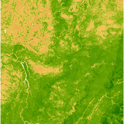
Gelişmiş Bitki Örtüsü İndeksi (EVI), her sahnenin yakın kızılötesi, kırmızı ve mavi bantlarından oluşturulur ve değeri -1,0 ile 1,0 arasında değişir. Ayrıntılar için Huete ve diğerleri (2002) başlıklı makaleyi inceleyin. Bu ürün, MODIS/006/MCD43A4 yüzey yansıtma kompozitlerinden oluşturulmuştur.
Bantlar
Bantlar
Piksel boyutu: 463,313 metre (tüm bantlar)
| Ad | Piksel Boyutu | Açıklama |
|---|---|---|
EVI |
463.313 metre | Gelişmiş Bitki Örtüsü İndeksi |
Kullanım Şartları
Kullanım Şartları
LP DAAC aracılığıyla edinilen MODIS verileri ve ürünleri, daha sonraki kullanım, satış veya yeniden dağıtım konusunda herhangi bir kısıtlamaya tabi değildir.
Earth Engine ile Keşif
Kod Düzenleyici (JavaScript)
var dataset = ee.ImageCollection('MODIS/MCD43A4_006_EVI')
                  .filter(ee.Filter.date('2018-04-01', '2018-06-01'));
var colorized = dataset.select('EVI');
var colorizedVis = {
  min: 0,
  max: 1,
  palette: [
    'ffffff', 'ce7e45', 'df923d', 'f1b555', 'fcd163', '99b718', '74a901',
    '66a000', '529400', '3e8601', '207401', '056201', '004c00', '023b01',
    '012e01', '011d01', '011301'
  ],
};
Map.setCenter(-7.03125, 31.0529339857, 2);
Map.addLayer(colorized, colorizedVis, 'Colorized');