- Veri Kümesi Kullanılabilirliği
- 2000-02-24T00:00:00Z–2023-02-17T00:00:00Z
- Veri Kümesi Üreticisi
- Sıklık
- 1 Gün
- Etiketler
Açıklama
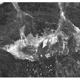
Yanık Alanı Dizin (BAI), kırmızı ve yakın kızılötesi bantlardan oluşturulur ve her pikselin spektral mesafesini referans spektral noktadan (odun kömürünün ölçülen yansıtma değeri) ölçer. Bu indeks, yangın sonrası görüntülerde kömür sinyalini vurgulamak için tasarlanmıştır. Ayrıntılar için Chuvieco ve diğerleri (2002)'ne bakın. Bu ürün, MODIS/006/MOD09GA yüzey yansıtma kompozitlerinden oluşturulur.
Bantlar
Bantlar
| Ad | Piksel Boyutu | Açıklama |
|---|---|---|
BAI |
463.313 metre | Yanık Alanı İndeksi |
Kullanım Şartları
Kullanım Şartları
LP DAAC aracılığıyla edinilen MODIS verileri ve ürünleri, daha sonraki kullanım, satış veya yeniden dağıtım konusunda herhangi bir kısıtlamaya tabi değildir.
Earth Engine ile Keşif
Kod Düzenleyici (JavaScript)
var dataset = ee.ImageCollection('MODIS/MOD09GA_006_BAI')
                  .filter(ee.Filter.date('2018-04-01', '2018-06-01'));
var scaled = dataset.select('BAI');
var scaledVis = {
  min: 0.0,
  max: 100.0,
};
Map.setCenter(-7.03125, 31.0529339857, 2);
Map.addLayer(scaled, scaledVis, 'Scaled');