- Disponibilidad del conjunto de datos
- 2002-07-04T00:00:00Z–2023-02-25T00:00:00Z
- Proveedor de conjuntos de datos
- Cadencia
- 1 día
- Etiquetas
Descripción
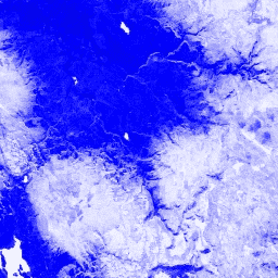
El índice de nieve de diferencia normalizada se usa para identificar la nieve en función de su reflectancia característicamente más alta en la porción visible del espectro en comparación con el infrarrojo medio. El NDSI se calcula con las bandas de infrarrojo medio y verde, y tiene un rango de -1.0 a 1.0. Consulta Riggs et al. (1994) para obtener más detalles. Este producto se genera a partir de los compuestos de reflectancia de superficie MODIS/006/MYD09GA.
Bandas
Bandas
| Nombre | Tamaño de los píxeles | Descripción |
|---|---|---|
NDSI |
463.313 metros | Índice de nieve de diferencia normalizada |
Condiciones de Uso
Condiciones de Uso
Los datos y productos de MODIS adquiridos a través del LP DAAC no tienen restricciones sobre su uso, venta o redistribución posteriores.
Explora con Earth Engine
Editor de código (JavaScript)
var dataset = ee.ImageCollection('MODIS/MYD09GA_006_NDSI')
                  .filter(ee.Filter.date('2018-04-01', '2018-06-01'));
var colorized = dataset.select('NDSI');
var colorizedVis = {
  palette: ['000088', '0000ff', '8888ff', 'ffffff'],
};
Map.setCenter(-7.03, 31.05, 2);
Map.addLayer(colorized, colorizedVis, 'Colorized');