- זמינות קבוצת הנתונים
- 2002-07-04T00:00:00Z–2023-02-25T00:00:00Z
- מפיק מערך הנתונים
- קצב
- יום אחד
- תגים
תיאור
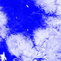
מדד ההבדל הנורמלי של השלג (NDSI) משמש לזיהוי שלג, על סמך רמת ההחזרה הגבוהה שלו באזור הנראה של הספקטרום בהשוואה לאינפרה-אדום הבינוני. המדד מחושב באמצעות התדרים הירוק והאינפרה-אדום הבינוני, והטווח שלו הוא -1.0 עד 1.0. פרטים נוספים זמינים במאמר של Riggs et al. (1994). המוצר הזה נוצר מנתוני ההחזרות של פני השטח של MODIS/006/MYD09GA.
תחום תדרים
תחום תדרים
גודל הפיקסל: 463.313 מטרים (כל הרצועות)
| שם | גודל הפיקסל | תיאור |
|---|---|---|
NDSI |
463.313 מטרים | מדד מנורמל של ההפרש לפי השלג |
תנאים והגבלות
תנאים והגבלות
אין הגבלות על שימוש, מכירה או הפצה מחדש של נתונים ומוצרים של MODIS לאחר שנרכשו דרך LP DAAC.
סיור עם פלטפורמת Earth Engine
עורך קוד (JavaScript)
var dataset = ee.ImageCollection('MODIS/MYD09GA_006_NDSI')
                  .filter(ee.Filter.date('2018-04-01', '2018-06-01'));
var colorized = dataset.select('NDSI');
var colorizedVis = {
  palette: ['000088', '0000ff', '8888ff', 'ffffff'],
};
Map.setCenter(-7.03, 31.05, 2);
Map.addLayer(colorized, colorizedVis, 'Colorized');