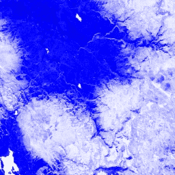
L'indice di neve a differenza normalizzata viene utilizzato per
identificare la neve in base alla sua riflettanza caratteristicamente più elevata nella
parte visibile dello spettro rispetto all'infrarosso medio. L'NDSI viene
calcolato utilizzando le bande del verde e dell'infrarosso medio e ha un intervallo compreso tra -1 e 1. Per informazioni dettagliate, consulta
Riggs et al. (1994). Questo prodotto è generato dai compositi di riflettanza di superficie MODIS/006/MYD09GA.
Bande
Bande
Nome
Dimensioni dei pixel
Descrizione
NDSI
463.313 metri
Indice di neve a differenza normalizzata
Termini e condizioni d'uso
I dati e i prodotti MODIS acquisiti tramite l'LP DAAC non prevedono limitazioni per l'utilizzo, la vendita o la ridistribuzione successivi.
L'indice di differenza normalizzata della neve viene utilizzato per identificare la neve in base alla sua riflettanza caratteristicamente più elevata nella porzione visibile dello spettro rispetto al medio infrarosso. L'NDSI viene calcolato utilizzando le bande del verde e del medio infrarosso e ha un intervallo compreso tra -1 e 1. Vedi Riggs et al. (1994) per…
[null,null,[],[[["\u003cp\u003eThe MODIS/MYD09GA_006_NDSI dataset provides daily Normalized Difference Snow Index (NDSI) values globally from July 4, 2002, to February 25, 2023.\u003c/p\u003e\n"],["\u003cp\u003eNDSI, derived from MODIS surface reflectance, helps identify snow cover by comparing reflectance in the visible and mid-infrared spectrum, with values ranging from -1.0 to 1.0.\u003c/p\u003e\n"],["\u003cp\u003eThe dataset is freely available for use, sale, and redistribution through Google Earth Engine, a platform for geospatial data analysis and visualization.\u003c/p\u003e\n"],["\u003cp\u003eThis dataset is provided by Google and is part of the MODIS Aqua collection, offering a 463.313-meter pixel resolution.\u003c/p\u003e\n"]]],["The MODIS/MYD09GA_006_NDSI dataset, provided by Google, spans from July 4, 2002, to February 25, 2023. It uses the Normalized Difference Snow Index (NDSI) to identify snow cover based on reflectance, with a daily cadence. The NDSI, computed from Green and Mid-IR bands, ranges from -1.0 to 1.0, having a 463.313-meter pixel size. Data from the dataset is unrestricted for use. Earth Engine provides tools to view the data.\n"],null,["# MODIS Aqua Daily NDSI\n\nDataset Availability\n: 2002-07-04T00:00:00Z--2023-02-25T00:00:00Z\n\nDataset Provider\n:\n\n\n [Google](https://earthengine.google.com/)\n\nCadence\n: 1 Day\n\nTags\n:\n aqua \n daily \n global \n modis \n myd09ga \n ndsi \n surface-reflectance \n usgs \nvegetation-indices \n\n#### Description\n\nThe Normalized Difference Snow Index is used to\nidentify snow, based on its characteristically higher reflectance in\nthe visible portion of the spectrum compared to the mid-IR. NDSI is\ncomputed using the Green and Mid-IR bands, and has a range of -1.0 to\n1.0. See\n[Riggs et al. (1994)](https://doi.org/10.1109/IGARSS.1994.399618)\nfor details. This product is generated from the MODIS/006/MYD09GA surface reflectance composites.\n\n### Bands\n\n**Bands**\n\n| Name | Pixel Size | Description |\n|--------|----------------|----------------------------------|\n| `NDSI` | 463.313 meters | Normalized Difference Snow Index |\n\n### Terms of Use\n\n**Terms of Use**\n\nMODIS data and products acquired through the LP DAAC have no restrictions on subsequent use, sale, or redistribution.\n\n### Explore with Earth Engine\n\n| **Important:** Earth Engine is a platform for petabyte-scale scientific analysis and visualization of geospatial datasets, both for public benefit and for business and government users. Earth Engine is free to use for research, education, and nonprofit use. To get started, please [register for Earth Engine access.](https://console.cloud.google.com/earth-engine)\n\n### Code Editor (JavaScript)\n\n```javascript\nvar dataset = ee.ImageCollection('MODIS/MYD09GA_006_NDSI')\n .filter(ee.Filter.date('2018-04-01', '2018-06-01'));\nvar colorized = dataset.select('NDSI');\nvar colorizedVis = {\n palette: ['000088', '0000ff', '8888ff', 'ffffff'],\n};\nMap.setCenter(-7.03, 31.05, 2);\nMap.addLayer(colorized, colorizedVis, 'Colorized');\n```\n[Open in Code Editor](https://code.earthengine.google.com/?scriptPath=Examples:Datasets/MODIS/MODIS_MYD09GA_006_NDSI) \n[MODIS Aqua Daily NDSI](/earth-engine/datasets/catalog/MODIS_MYD09GA_006_NDSI) \nThe Normalized Difference Snow Index is used to identify snow, based on its characteristically higher reflectance in the visible portion of the spectrum compared to the mid-IR. NDSI is computed using the Green and Mid-IR bands, and has a range of -1.0 to 1.0. See Riggs et al. (1994) for ... \nMODIS/MYD09GA_006_NDSI, aqua,daily,global,modis,ndsi,surface-reflectance,usgs,vegetation-indices \n2002-07-04T00:00:00Z/2023-02-25T00:00:00Z \n-90 -180 90 180 \nGoogle Earth Engine \nhttps://developers.google.com/earth-engine/datasets\n\n- [](https://doi.org/https://earthengine.google.com/)\n- [](https://doi.org/https://developers.google.com/earth-engine/datasets/catalog/MODIS_MYD09GA_006_NDSI)"]]