- Veri Kümesi Kullanılabilirliği
- 2002-07-04T00:00:00Z–2023-02-25T00:00:00Z
- Veri Kümesi Üreticisi
- Sıklık
- 1 Gün
- Etiketler
Açıklama
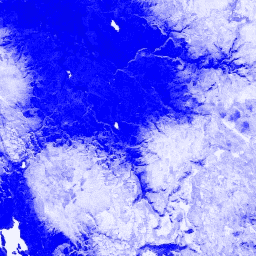
Normalleştirilmiş Fark Kar İndeksi, spektrumun görünür kısmında orta kızılötesine kıyasla karakteristik olarak daha yüksek yansıtma özelliğine sahip olması nedeniyle karı tanımlamak için kullanılır. NDSI, yeşil ve orta kızılötesi bantlar kullanılarak hesaplanır ve -1,0 ile 1,0 arasında bir aralığa sahiptir. Ayrıntılar için Riggs ve diğerleri (1994) kaynağına bakın. Bu ürün, MODIS/006/MYD09GA yüzey yansıtma kompozitlerinden oluşturulmuştur.
Bantlar
Bantlar
Piksel boyutu: 463,313 metre (tüm bantlar)
| Ad | Piksel Boyutu | Açıklama |
|---|---|---|
NDSI |
463.313 metre | Normalleştirilmiş Fark Kar İndeksi |
Kullanım Şartları
Kullanım Şartları
LP DAAC aracılığıyla edinilen MODIS verileri ve ürünleri, daha sonraki kullanım, satış veya yeniden dağıtım konusunda herhangi bir kısıtlamaya tabi değildir.
Earth Engine ile Keşif
Kod Düzenleyici (JavaScript)
var dataset = ee.ImageCollection('MODIS/MYD09GA_006_NDSI')
                  .filter(ee.Filter.date('2018-04-01', '2018-06-01'));
var colorized = dataset.select('NDSI');
var colorizedVis = {
  palette: ['000088', '0000ff', '8888ff', 'ffffff'],
};
Map.setCenter(-7.03, 31.05, 2);
Map.addLayer(colorized, colorizedVis, 'Colorized');