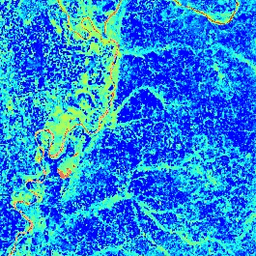
El Índice de Agua Diferencial Normalizado (NDWI) es sensible a los cambios en el contenido de agua líquida de las copas de la vegetación. Se deriva de la banda del infrarrojo cercano y de una segunda banda del infrarrojo, de aproximadamente 1.24 μm cuando está disponible y de la banda del infrarrojo disponible más cercana en otros casos. Su valor varía de -1.0 a 1.0. Consulta Gao (1996) para obtener más información. Este producto se genera a partir de los compuestos de reflectancia de superficie MODIS/006/MYD09GA.
Bandas
Bandas
Nombre
Tamaño de los píxeles
Descripción
NDWI
463.313 metros
Índice de agua de diferencia normalizada
Condiciones de Uso
Condiciones de Uso
Los datos y productos de MODIS adquiridos a través del LP DAAC no tienen restricciones sobre su uso, venta o redistribución posteriores.
El Índice de diferencia normalizada del agua (NDWI) es sensible a los cambios en el contenido de agua líquida de las copas de la vegetación. Se deriva de la banda del infrarrojo cercano y una segunda banda del infrarrojo, de aproximadamente 1.24 μm cuando está disponible y la banda del infrarrojo disponible más cercana en otros casos. Su valor varía de -1.0 a 1.0. Consulta Gao (1996)…
[null,null,[],[[["\u003cp\u003eThe MODIS/MYD09GA_006_NDWI dataset provides daily Normalized Difference Water Index (NDWI) data derived from MODIS Aqua surface reflectance composites.\u003c/p\u003e\n"],["\u003cp\u003eNDWI is sensitive to changes in liquid water content of vegetation canopies and ranges from -1.0 to 1.0.\u003c/p\u003e\n"],["\u003cp\u003eThis dataset is freely available for use with Google Earth Engine and has global coverage from 2002 to 2023.\u003c/p\u003e\n"],["\u003cp\u003eThe dataset has a spatial resolution of 463.313 meters and can be used to monitor vegetation water content changes.\u003c/p\u003e\n"],["\u003cp\u003eMODIS data acquired through the LP DAAC has no restrictions on subsequent use, sale, or redistribution.\u003c/p\u003e\n"]]],["The dataset, provided by Google, contains the Normalized Difference Water Index (NDWI) derived from MODIS/MYD09GA surface reflectance. This daily, global dataset, available from 2002-07-04 to 2023-02-25, measures liquid water content in vegetation using Near-IR and another IR band, with values ranging from -1.0 to 1.0. It is free for research, education, and nonprofit use via the Earth Engine platform. The NDWI band has a pixel size of 463.313 meters.\n"],null,["# MODIS Aqua Daily NDWI\n\nDataset Availability\n: 2002-07-04T00:00:00Z--2023-02-25T00:00:00Z\n\nDataset Provider\n:\n\n\n [Google](https://earthengine.google.com/)\n\nCadence\n: 1 Day\n\nTags\n:\n aqua \n daily \n global \n modis \n myd09ga \n ndwi \n surface-reflectance \n usgs \nvegetation-indices \n\n#### Description\n\nThe Normalized Difference Water Index (NDWI) is sensitive\nto changes in liquid water content of vegetation canopies. It is\nderived from the Near-IR band and a second IR band, ≈1.24μm when\navailable and the nearest available IR band otherwise. It ranges in\nvalue from -1.0 to 1.0. See\n[Gao (1996)](https://www.sciencedirect.com/science/article/pii/S0034425796000673)\nfor details. This product is generated from the MODIS/006/MYD09GA surface reflectance composites.\n\n### Bands\n\n**Bands**\n\n| Name | Pixel Size | Description |\n|--------|----------------|-----------------------------------|\n| `NDWI` | 463.313 meters | Normalized Difference Water Index |\n\n### Terms of Use\n\n**Terms of Use**\n\nMODIS data and products acquired through the LP DAAC have no restrictions on subsequent use, sale, or redistribution.\n\n### Explore with Earth Engine\n\n| **Important:** Earth Engine is a platform for petabyte-scale scientific analysis and visualization of geospatial datasets, both for public benefit and for business and government users. Earth Engine is free to use for research, education, and nonprofit use. To get started, please [register for Earth Engine access.](https://console.cloud.google.com/earth-engine)\n\n### Code Editor (JavaScript)\n\n```javascript\nvar dataset = ee.ImageCollection('MODIS/MYD09GA_006_NDWI')\n .filter(ee.Filter.date('2018-04-01', '2018-06-01'));\nvar colorized = dataset.select('NDWI');\nvar colorizedVis = {\n min: 0.0,\n max: 1.0,\n palette: ['0000ff', '00ffff', 'ffff00', 'ff0000', 'ffffff'],\n};\nMap.setCenter(-7.03125, 31.0529339857, 2);\nMap.addLayer(colorized, colorizedVis, 'Colorized');\n```\n[Open in Code Editor](https://code.earthengine.google.com/?scriptPath=Examples:Datasets/MODIS/MODIS_MYD09GA_006_NDWI) \n[MODIS Aqua Daily NDWI](/earth-engine/datasets/catalog/MODIS_MYD09GA_006_NDWI) \nThe Normalized Difference Water Index (NDWI) is sensitive to changes in liquid water content of vegetation canopies. It is derived from the Near-IR band and a second IR band, ≈1.24μm when available and the nearest available IR band otherwise. It ranges in value from -1.0 to 1.0. See Gao (1996) ... \nMODIS/MYD09GA_006_NDWI, aqua,daily,global,modis,ndwi,surface-reflectance,usgs,vegetation-indices \n2002-07-04T00:00:00Z/2023-02-25T00:00:00Z \n-90 -180 90 180 \nGoogle Earth Engine \nhttps://developers.google.com/earth-engine/datasets\n\n- [](https://doi.org/https://earthengine.google.com/)\n- [](https://doi.org/https://developers.google.com/earth-engine/datasets/catalog/MODIS_MYD09GA_006_NDWI)"]]