- Disponibilité de l'ensemble de données
- 2002-07-04T00:00:00Z–2023-02-25T00:00:00Z
- Producteur de l'ensemble de données
- Fréquence de mise à jour
- 1 jour
- Tags
Description
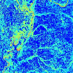
L'indice de différence normalisée de l'eau (Normalized Difference Water Index, NDWI) est sensible aux variations de la teneur en eau liquide des canopées. Il est dérivée de la bande IR proche et d'une deuxième bande IR, ≈1,24 μm lorsqu'elle est disponible et la bande IR la plus proche disponible dans le cas contraire. Sa valeur est comprise entre -1,0 et 1,0. Pour en savoir plus, consultez Gao (1996). Ce produit est généré à partir des composites de réflectance de surface MODIS/006/MYD09GA.
Bandes
Bandes de fréquences
Taille des pixels : 463,313 mètres (toutes les bandes)
| Nom | Taille des pixels | Description |
|---|---|---|
NDWI |
463.313 mètres | Indice de différence normalisée de l'eau |
Conditions d'utilisation
Conditions d'utilisation
Les données et produits MODIS acquis par le biais du LP DAAC ne sont soumis à aucune restriction concernant leur utilisation, leur vente ou leur redistribution ultérieures.
Explorer avec Earth Engine
Éditeur de code (JavaScript)
var dataset = ee.ImageCollection('MODIS/MYD09GA_006_NDWI')
                  .filter(ee.Filter.date('2018-04-01', '2018-06-01'));
var colorized = dataset.select('NDWI');
var colorizedVis = {
  min: 0.0,
  max: 1.0,
  palette: ['0000ff', '00ffff', 'ffff00', 'ff0000', 'ffffff'],
};
Map.setCenter(-7.03125, 31.0529339857, 2);
Map.addLayer(colorized, colorizedVis, 'Colorized');