M2T1NXRAD (বা tavg1_2d_rad_Nx) হল গবেষণা এবং অ্যাপ্লিকেশন সংস্করণ 2 (MERRA-2) এর জন্য আধুনিক-যুগের রেট্রোস্পেক্টিভ বিশ্লেষণে প্রতি ঘণ্টায় গড় ডেটা সংগ্রহ। এই সংগ্রহে রেডিয়েশন ডায়াগনস্টিকস রয়েছে, যেমন সারফেস অ্যালবেডো, ক্লাউড এরিয়া ভগ্নাংশ, মেঘের অপটিক্যাল বেধে, পৃষ্ঠের ইনকামিং শর্টওয়েভ ফ্লাক্স (অর্থাৎ সৌর বিকিরণ), সারফেস নেট ডাউনওয়ার্ড শর্টওয়েভ ফ্লাক্স, এবং TOA (বায়ুমন্ডলের উপরে) (অর্থাৎ বহির্গামী লংওয়েভ রেডিয়েশন (OLAR))। ডেটা ক্ষেত্রটি 00:30 UTC থেকে শুরু হওয়া এক ঘন্টার কেন্দ্রীয় সময় দিয়ে টাইম-স্ট্যাম্প করা হয়, যেমন: 00:30, 01:30, ... , 23:30 UTC।
MERRA-2 হল গডার্ড আর্থ অবজারভিং সিস্টেম মডেল (GEOS) সংস্করণ 5.12.4 ব্যবহার করে NASA গ্লোবাল মডেলিং অ্যান্ড অ্যাসিমিলেশন অফিস (GMAO) দ্বারা উত্পাদিত স্যাটেলাইট যুগের জন্য বৈশ্বিক বায়ুমণ্ডলীয় পুনর্বিশ্লেষণের সর্বশেষ সংস্করণ। ডেটাসেটটি 1980-বর্তমান সময়কালকে কভার করে একটি মাস শেষ হওয়ার পর ~3 সপ্তাহের বিলম্বের সাথে।
ব্যান্ড
পিক্সেল সাইজ 69375 মিটার
Y পিক্সেল সাইজ 55000 মিটার
ব্যান্ড
নাম
ইউনিট
মিন
সর্বোচ্চ
পিক্সেল সাইজ
বর্ণনা
ALBEDO
0.01*
0.898471*
মিটার
সারফেস অ্যালবেডো
ALBNIRDF
0.017455*
0.820016*
মিটার
কাছাকাছি ইনফ্রারেড ডিফিউজের জন্য সারফেস অ্যালবেডো
ALBNIRDR
0.018709*
0.82001*
মিটার
কাছাকাছি ইনফ্রারেড মরীচি জন্য সারফেস অ্যালবেডো
ALBVISDF
0.016788*
0.959771*
মিটার
দৃশ্যমান বিচ্ছুরণের জন্য সারফেস অ্যালবেডো
ALBVISDR
0.01853*
0.959762*
মিটার
দৃশ্যমান মরীচির জন্য সারফেস অ্যালবেডো
CLDHGH
0*
0.999236*
মিটার
উচ্চ মেঘের জন্য মেঘ এলাকার ভগ্নাংশ
CLDLOW
0*
0.999997*
মিটার
কম মেঘের জন্য ক্লাউড এরিয়ার ভগ্নাংশ
CLDMID
0*
0.998779*
মিটার
মধ্যম মেঘের জন্য ক্লাউড এরিয়ার ভগ্নাংশ
CLDTOT
0*
1*
মিটার
মোট মেঘ এলাকার ভগ্নাংশ
EMIS
0.943074*
0.999993*
মিটার
পৃষ্ঠ নির্গমন
LWGABCLRCLN
W/m^2
41.1408*
458.523*
মিটার
পরিষ্কার আকাশ এবং কোনো অ্যারোসল নেই অনুমান করে পৃষ্ঠ দীর্ঘতরঙ্গ বিকিরণ শোষণ করে
LWGABCLR
W/m^2
41.1414*
465.929*
মিটার
পরিষ্কার আকাশ অনুমান করে দীর্ঘতরঙ্গ বিকিরণ শোষিত পৃষ্ঠ
LWGAB
W/m^2
41.1446*
482.398*
মিটার
সারফেস শোষিত দীর্ঘতরঙ্গ বিকিরণ
LWGEM
W/m^2
67.5297*
630.29*
মিটার
পৃষ্ঠ থেকে নির্গত লংওয়েভ প্রবাহ
LWGNTCLRCLN
W/m^2
-248.748*
61.0736*
মিটার
সারফেস নেট নিম্নগামী দীর্ঘতরঙ্গ প্রবাহ অনুমান করে পরিষ্কার আকাশ এবং কোন অ্যারোসল নেই
LWGNTCLR
W/m^2
-248.653*
62.2794*
মিটার
সারফেস নেট নিম্নগামী দীর্ঘতরঙ্গ প্রবাহ পরিষ্কার আকাশ অনুমান করে
LWGNT
W/m^2
-268.862*
77.255*
মিটার
সারফেস নেট নিম্নগামী লংওয়েভ ফ্লাক্স
LWTUPCLRCLN
W/m^2
80.6768*
372.229*
মিটার
স্বচ্ছ আকাশ এবং কোনো অ্যারোসল নেই বলে TOA-তে দীর্ঘতরঙ্গের প্রবাহ বৃদ্ধি পাচ্ছে
LWTUPCLR
W/m^2
80.6768*
372.229*
মিটার
পরিষ্কার আকাশ অনুমান করে TOA-তে দীর্ঘতরঙ্গ প্রবাহিত হচ্ছে
LWTUP
W/m^2
80.6506*
370.868*
মিটার
TOA এ দীর্ঘতরঙ্গ প্রবাহিত হচ্ছে
SWGDNCLR
W/m^2
-0.008217*
1155.5*
মিটার
পরিষ্কার আকাশ অনুমান করে সারফেস ইনকামিং শর্টওয়েভ ফ্লাক্স
SWGDN
W/m^2
0*
1127.49*
মিটার
সারফেস ইনকামিং শর্টওয়েভ ফ্লাক্স
SWGNTCLN
W/m^2
0*
1088.42*
মিটার
সারফেস নেট নিম্নগামী শর্টওয়েভ ফ্লাক্স অনুমান করে কোন অ্যারোসল নেই
SWGNTCLRCLN
W/m^2
-3.2e-05*
1088.42*
মিটার
সারফেস নেট নিম্নগামী শর্টওয়েভ ফ্লাক্স পরিষ্কার আকাশ এবং অ্যারোসল নেই
SWGNTCLR
W/m^2
-0.001333*
1083.95*
মিটার
সারফেস নেট নিম্নগামী শর্টওয়েভ ফ্লাক্স পরিষ্কার আকাশ অনুমান করে
SWGNT
W/m^2
0*
1083.95*
মিটার
সারফেস নেট নিম্নগামী শর্টওয়েভ প্রবাহ
SWTDN
W/m^2
0*
1404.28*
মিটার
TOA ইনকামিং শর্টওয়েভ ফ্লাক্স
SWTNTCLN
W/m^2
0*
1315.89*
মিটার
TOA নেট নিম্নগামী শর্টওয়েভ ফ্লাক্স অনুমান করে কোন অ্যারোসল নেই
SWTNTCLRCLN
W/m^2
0*
1317.5*
মিটার
TOA নেট নিম্নগামী শর্টওয়েভ ফ্লাক্স পরিষ্কার আকাশ এবং কোনো অ্যারোসল নেই
SWTNTCLR
W/m^2
0*
1316.5*
মিটার
TOA নেট নিম্নগামী শর্টওয়েভ ফ্লাক্স পরিষ্কার আকাশ অনুমান করে
SWTNT
W/m^2
0*
1313.33*
মিটার
TOA নেট নিম্নগামী শর্টওয়েভ ফ্লাক্স
TAUHGH
0*
142.188*
মিটার
ক্লাউডে উচ্চ মেঘের অপটিক্যাল বেধ (রপ্তানি)
TAULOW
0*
318.218*
মিটার
ক্লাউডে কম মেঘের অপটিক্যাল পুরুত্ব
TAUMID
0*
252.995*
মিটার
ক্লাউডে মধ্যম মেঘের অপটিক্যাল পুরুত্ব
TAUTOT
0*
348.125*
মিটার
ক্লাউডে সমস্ত মেঘের অপটিক্যাল পুরুত্ব
TS
কে
185.73*
328.864*
মিটার
পৃষ্ঠের ত্বকের তাপমাত্রা
* আনুমানিক সর্বনিম্ন বা সর্বোচ্চ মান
ব্যবহারের শর্তাবলী
ব্যবহারের শর্তাবলী
NASA গবেষণা এবং অ্যাপ্লিকেশন সম্প্রদায়, বেসরকারী শিল্প, একাডেমিয়া এবং সাধারণ জনগণের সাথে সমস্ত ডেটা সম্পূর্ণ এবং খোলামেলা ভাগ করে নেওয়ার প্রচার করে৷
M2T1NXRAD (বা tavg1_2d_rad_Nx) হল গবেষণা এবং অ্যাপ্লিকেশন সংস্করণ 2 (MERRA-2) এর জন্য আধুনিক-যুগের রেট্রোস্পেক্টিভ বিশ্লেষণে প্রতি ঘণ্টায় গড় ডেটা সংগ্রহ। এই সংগ্রহে রয়েছে রেডিয়েশন ডায়াগনস্টিকস, যেমন সারফেস অ্যালবেডো, ক্লাউড এরিয়া ভগ্নাংশ, ক্লাউড অপটিক্যাল পুরুত্ব, সারফেস ইনকামিং শর্টওয়েভ ফ্লাক্স (যেমন সোলার রেডিয়েশন), সারফেস নেট ডাউনওয়ার্ড শর্টওয়েভ ফ্লাক্স এবং …
NASA/GSFC/MERRA/rad/2, অ্যালবেডো, বায়ুমণ্ডল, জলবায়ু, নির্গমন, মেরা, শর্টওয়েভ, তাপমাত্রা
[null,null,[],[[["\u003cp\u003eThe NASA/GSFC/MERRA/rad/2 dataset provides hourly time-averaged radiation diagnostics from the Modern-Era Retrospective analysis for Research and Applications version 2 (MERRA-2).\u003c/p\u003e\n"],["\u003cp\u003eThis dataset includes measurements such as surface albedo, cloud area fraction, optical thickness, shortwave flux, and longwave flux.\u003c/p\u003e\n"],["\u003cp\u003eData is available from 1980 to near-present with a latency of approximately 3 weeks after the end of a month and is provided at a spatial resolution of 55,000 - 69,375 meters.\u003c/p\u003e\n"],["\u003cp\u003eNASA promotes open sharing of this data with research, industry, academia, and the public.\u003c/p\u003e\n"],["\u003cp\u003eThe data is easily accessible through Google Earth Engine using the provided Earth Engine Snippet.\u003c/p\u003e\n"]]],["The NASA/MERRA-2 dataset (M2T1NXRAD) provides hourly, time-averaged radiation diagnostics from 1980 to 2025, with a ~3-week latency. Data includes surface albedo, cloud fractions, optical thickness, and shortwave/longwave fluxes. It is produced by NASA GMAO using GEOS model version 5.12.4. Data is accessible via Google Earth Engine with specific bands available like ALBEDO, CLDHGH, SWGDN and more. Pixel size is 69375x55000 meters.\n"],null,["Dataset Availability\n: 1980-01-01T00:00:00Z--2025-08-01T23:00:00Z\n\nDataset Provider\n:\n\n\n [NASA/MERRA](https://gmao.gsfc.nasa.gov/reanalysis/MERRA-2/)\n\nCadence\n: 1 Hour\n\nTags\n:\n[albedo](/earth-engine/datasets/tags/albedo) [atmosphere](/earth-engine/datasets/tags/atmosphere) [climate](/earth-engine/datasets/tags/climate) [emissivity](/earth-engine/datasets/tags/emissivity) [merra](/earth-engine/datasets/tags/merra) [shortwave](/earth-engine/datasets/tags/shortwave) [temperature](/earth-engine/datasets/tags/temperature) \n\nDescription \nM2T1NXRAD (or tavg1_2d_rad_Nx) is an hourly time-averaged data\ncollection in Modern-Era Retrospective analysis for Research and\nApplications version 2 (MERRA-2). This collection consists of radiation\ndiagnostics, such as surface albedo, cloud area fraction, in cloud\noptical thickness, surface incoming shortwave flux (i.e. solar\nradiation), surface net downward shortwave flux, and upwelling longwave\nflux at TOA (top of atmosphere) (i.e. outgoing longwave radiation (OLR)\nat TOA). The data field is time-stamped with the central time of an hour\nstarting from 00:30 UTC, e.g.: 00:30, 01:30, ... , 23:30 UTC.\n\nMERRA-2 is the latest version of global atmospheric reanalysis for the\nsatellite era produced by NASA Global Modeling and Assimilation Office\n(GMAO) using the Goddard Earth Observing System Model (GEOS) version\n5.12.4. The dataset covers the period of 1980-present with the latency\nof \\~3 weeks after the end of a month.\n\nBands\n\n\n**Pixel Size**\n\n69375 meters\n\n\n**Y Pixel Size**\n\n55000 meters\n\n**Bands**\n\n| Name | Units | Min | Max | Pixel Size | Description |\n|---------------|--------|-------------|------------|------------|-----------------------------------------------------------------------|\n| `ALBEDO` | | 0.01\\* | 0.898471\\* | meters | Surface albedo |\n| `ALBNIRDF` | | 0.017455\\* | 0.820016\\* | meters | Surface albedo for near infrared diffuse |\n| `ALBNIRDR` | | 0.018709\\* | 0.82001\\* | meters | Surface albedo for near infrared beam |\n| `ALBVISDF` | | 0.016788\\* | 0.959771\\* | meters | Surface albedo for visible diffuse |\n| `ALBVISDR` | | 0.01853\\* | 0.959762\\* | meters | Surface albedo for visible beam |\n| `CLDHGH` | | 0\\* | 0.999236\\* | meters | Cloud area fraction for high clouds |\n| `CLDLOW` | | 0\\* | 0.999997\\* | meters | Cloud area fraction for low clouds |\n| `CLDMID` | | 0\\* | 0.998779\\* | meters | Cloud area fraction for middle clouds |\n| `CLDTOT` | | 0\\* | 1\\* | meters | Total cloud area fraction |\n| `EMIS` | | 0.943074\\* | 0.999993\\* | meters | Surface emissivity |\n| `LWGABCLRCLN` | W/m\\^2 | 41.1408\\* | 458.523\\* | meters | Surface absorbed longwave radiation assuming clear sky and no aerosol |\n| `LWGABCLR` | W/m\\^2 | 41.1414\\* | 465.929\\* | meters | Surface absorbed longwave radiation assuming clear sky |\n| `LWGAB` | W/m\\^2 | 41.1446\\* | 482.398\\* | meters | Surface absorbed longwave radiation |\n| `LWGEM` | W/m\\^2 | 67.5297\\* | 630.29\\* | meters | Longwave flux emitted from surface |\n| `LWGNTCLRCLN` | W/m\\^2 | -248.748\\* | 61.0736\\* | meters | Surface net downward longwave flux assuming clear sky and no aerosol |\n| `LWGNTCLR` | W/m\\^2 | -248.653\\* | 62.2794\\* | meters | Surface net downward longwave flux assuming clear sky |\n| `LWGNT` | W/m\\^2 | -268.862\\* | 77.255\\* | meters | Surface net downward longwave flux |\n| `LWTUPCLRCLN` | W/m\\^2 | 80.6768\\* | 372.229\\* | meters | Upwelling longwave flux at TOA assuming clear sky and no aerosol |\n| `LWTUPCLR` | W/m\\^2 | 80.6768\\* | 372.229\\* | meters | Upwelling longwave flux at TOA assuming clear sky |\n| `LWTUP` | W/m\\^2 | 80.6506\\* | 370.868\\* | meters | Upwelling longwave flux at TOA |\n| `SWGDNCLR` | W/m\\^2 | -0.008217\\* | 1155.5\\* | meters | Surface incoming shortwave flux assuming clear sky |\n| `SWGDN` | W/m\\^2 | 0\\* | 1127.49\\* | meters | Surface incoming shortwave flux |\n| `SWGNTCLN` | W/m\\^2 | 0\\* | 1088.42\\* | meters | Surface net downward shortwave flux assuming no aerosol |\n| `SWGNTCLRCLN` | W/m\\^2 | -3.2e-05\\* | 1088.42\\* | meters | Surface net downward shortwave flux assuming clear sky and no aerosol |\n| `SWGNTCLR` | W/m\\^2 | -0.001333\\* | 1083.95\\* | meters | Surface net downward shortwave flux assuming clear sky |\n| `SWGNT` | W/m\\^2 | 0\\* | 1083.95\\* | meters | Surface net downward shortwave flux |\n| `SWTDN` | W/m\\^2 | 0\\* | 1404.28\\* | meters | TOA incoming shortwave flux |\n| `SWTNTCLN` | W/m\\^2 | 0\\* | 1315.89\\* | meters | TOA net downward shortwave flux assuming no aerosol |\n| `SWTNTCLRCLN` | W/m\\^2 | 0\\* | 1317.5\\* | meters | TOA net downward shortwave flux assuming clear sky and no aerosol |\n| `SWTNTCLR` | W/m\\^2 | 0\\* | 1316.5\\* | meters | TOA net downward shortwave flux assuming clear sky |\n| `SWTNT` | W/m\\^2 | 0\\* | 1313.33\\* | meters | TOA net downward shortwave flux |\n| `TAUHGH` | | 0\\* | 142.188\\* | meters | In cloud optical thickness of high clouds(export) |\n| `TAULOW` | | 0\\* | 318.218\\* | meters | In cloud optical thickness of low clouds |\n| `TAUMID` | | 0\\* | 252.995\\* | meters | In cloud optical thickness of middle clouds |\n| `TAUTOT` | | 0\\* | 348.125\\* | meters | In cloud optical thickness of all clouds |\n| `TS` | K | 185.73\\* | 328.864\\* | meters | Surface skin temperature |\n\n\\* estimated min or max value\n\nTerms of Use\n\n**Terms of Use**\n\nNASA promotes the full and open sharing of all data with research and\napplications communities, private industry, academia, and the general\npublic.\n\nExplore with Earth Engine **Important:** Earth Engine is a platform for petabyte-scale scientific analysis and visualization of geospatial datasets, both for public benefit and for business and government users. Earth Engine is free to use for research, education, and nonprofit use. To get started, please [register for Earth Engine access.](https://console.cloud.google.com/earth-engine)\n\nCode Editor (JavaScript) \n\n```javascript\n
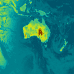
var dataset = ee.ImageCollection('NASA/GSFC/MERRA/rad/2')\n .filter(ee.Filter.date('2022-02-01', '2022-02-02')).first();\nvar surface_albedo = dataset.select('ALBEDO');\nvar saVis = {\n min: -0.428147,\n max: 0.833350,\n palette: ['001137', '01abab', 'e7eb05', '620500']\n};\nMap.setCenter(-95, 39, 2);\nMap.addLayer(surface_albedo, saVis, 'Surface albedo');\n```\n[Open in Code Editor](https://code.earthengine.google.com/?scriptPath=Examples:Datasets/NASA/NASA_GSFC_MERRA_rad_2) \n[MERRA-2 M2T1NXRAD: Radiation Diagnostics V5.12.4](/earth-engine/datasets/catalog/NASA_GSFC_MERRA_rad_2) \nM2T1NXRAD (or tavg1_2d_rad_Nx) is an hourly time-averaged data collection in Modern-Era Retrospective analysis for Research and Applications version 2 (MERRA-2). This collection consists of radiation diagnostics, such as surface albedo, cloud area fraction, in cloud optical thickness, surface incoming shortwave flux (i.e. solar radiation), surface net downward shortwave flux, and ... \nNASA/GSFC/MERRA/rad/2, albedo,atmosphere,climate,emissivity,merra,shortwave,temperature \n1980-01-01T00:00:00Z/2025-08-01T23:00:00Z \n-90 -180 90 180 \nGoogle Earth Engine \nhttps://developers.google.com/earth-engine/datasets\n\n- [](https://doi.org/https://gmao.gsfc.nasa.gov/reanalysis/MERRA-2/)\n- [](https://doi.org/https://developers.google.com/earth-engine/datasets/catalog/NASA_GSFC_MERRA_rad_2)"]]