M2T1NXRAD (ou tavg1_2d_rad_Nx) é uma coleta de dados com média horária na análise retrospectiva da era moderna para pesquisa e aplicativos, versão 2 (MERRA-2). Essa coleção consiste em diagnósticos de radiação, como albedo da superfície, fração da área de nuvem, espessura óptica na nuvem, fluxo de ondas curtas incidentes na superfície (ou seja, radiação solar), fluxo de ondas curtas descendentes líquidas na superfície e fluxo de ondas longas ascendentes no TOA (parte superior da atmosfera), ou seja, radiação de ondas longas (OLR) no TOA. O campo de dados tem um carimbo de data/hora com o horário central de uma hora
a partir das 00h30 UTC, por exemplo: 00:30, 01:30, ... , 23:30 UTC.
O MERRA-2 é a versão mais recente da reanálise atmosférica global para a era dos satélites, produzida pelo Global Modeling and Assimilation Office (GMAO) da NASA usando o Goddard Earth Observing System Model (GEOS), versão 5.12.4. O conjunto de dados abrange o período de 1980 até o presente, com uma latência de aproximadamente três semanas após o fim de um mês.
Bandas
Tamanho do pixel 69375 metros
Tamanho do pixel Y 55.000 metros
Bandas
Nome
Unidades
Mín.
Máx.
Tamanho do pixel
Descrição
ALBEDO
0,01*
0,898471*
metros
Albedo da superfície
ALBNIRDF
0,017455*
0,820016*
metros
Albedo da superfície para infravermelho próximo difuso
ALBNIRDR
0,018709*
0,82001*
metros
Albedo da superfície para feixe de infravermelho próximo
ALBVISDF
0,016788*
0,959771*
metros
Albedo da superfície para difusão visível
ALBVISDR
0,01853*
0,959762*
metros
Albedo da superfície para feixe visível
CLDHGH
0*
0,999236*
metros
Fração da área de nuvem para nuvens altas
CLDLOW
0*
0,999997*
metros
Fração da área de nuvem para nuvens baixas
CLDMID
0*
0,998779*
metros
Fração da área de nuvem para nuvens médias
CLDTOT
0*
1*
metros
Fração da área total de nuvem
EMIS
0,943074*
0,999993*
metros
Emissividade da superfície
LWGABCLRCLN
W/m^2
41.1408*
458.523*
metros
A superfície absorveu radiação de ondas longas, considerando céu limpo e sem aerossol
LWGABCLR
W/m^2
41.1414*
465.929*
metros
A superfície absorveu radiação de ondas longas, considerando céu limpo
LWGAB
W/m^2
41,1446*
482.398*
metros
Radiação de ondas longas absorvida pela superfície
LWGEM
W/m^2
67,5297*
630.29*
metros
Fluxo de ondas longas emitido da superfície
LWGNTCLRCLN
W/m^2
-248.748*
61,0736*
metros
Fluxo de onda longa descendente da rede da superfície, assumindo céu claro e sem aerossol
LWGNTCLR
W/m^2
-248.653*
62,2794*
metros
Fluxo de ondas longas descendentes da rede de superfície considerando céu claro
LWGNT
W/m^2
-268.862*
77,255*
metros
Fluxo de onda longa descendente da rede de superfície
LWTUPCLRCLN
W/m^2
80,6768*
372.229*
metros
Fluxo de ondas longas de ressurgência na parte superior da atmosfera, considerando céu claro e sem aerossol
LWTUPCLR
W/m^2
80,6768*
372.229*
metros
Fluxo de ondas longas de ressurgência no TOA, considerando céu claro
LWTUP
W/m^2
80,6506*
370.868*
metros
Fluxo de ondas longas ascendentes na TOA
SWGDNCLR
W/m^2
-0,008217*
1155,5*
metros
Fluxo de ondas curtas incidentes na superfície, supondo céu claro
SWGDN
W/m^2
0*
1127,49*
metros
Fluxo de ondas curtas incidentes na superfície
SWGNTCLN
W/m^2
0*
1088,42*
metros
Fluxo de ondas curtas descendente líquido da superfície, sem considerar aerossóis
SWGNTCLRCLN
W/m^2
-3,2e-05*
1088,42*
metros
Fluxo de ondas curtas descendente líquido da superfície, considerando céu claro e sem aerossol
SWGNTCLR
W/m^2
-0,001333*
1083,95*
metros
Fluxo de ondas curtas descendentes da rede de superfície considerando céu limpo
SWGNT
W/m^2
0*
1083,95*
metros
Fluxo de ondas curtas descendente líquido na superfície
SWTDN
W/m^2
0*
1404,28*
metros
Fluxo de ondas curtas de TOA
SWTNTCLN
W/m^2
0*
1315,89*
metros
Fluxo de ondas curtas descendente líquido no TOA sem considerar aerossóis
SWTNTCLRCLN
W/m^2
0*
1317,5*
metros
Fluxo de ondas curtas descendente líquido no TOA, assumindo céu claro e sem aerossol
SWTNTCLR
W/m^2
0*
1316,5*
metros
Fluxo de ondas curtas descendentes da rede TOA, considerando céu limpo
SWTNT
W/m^2
0*
1313,33*
metros
Fluxo de ondas curtas descendente líquido da TOA
TAUHGH
0*
142.188*
metros
Espessura óptica na nuvem de nuvens altas(exportação)
TAULOW
0*
318.218*
metros
Na espessura óptica de nuvens baixas
TAUMID
0*
252.995*
metros
Espessura óptica das nuvens médias
TAUTOT
0*
348.125*
metros
Na espessura óptica da nuvem de todas as nuvens
TS
K
185,73*
328.864*
metros
Temperatura da pele na superfície
* valor mínimo ou máximo estimado
Termos de Uso
Termos de Uso
A NASA promove o compartilhamento total e aberto de todos os dados com as comunidades de pesquisa e aplicativos, a indústria privada, a academia e o público em geral.
M2T1NXRAD (ou tavg1_2d_rad_Nx) é uma coleta de dados com média horária na análise retrospectiva da era moderna para pesquisa e aplicações, versão 2 (MERRA-2). Essa coleta consiste em diagnósticos de radiação, como albedo da superfície, fração da área de nuvem, espessura óptica na nuvem, fluxo de ondas curtas incidentes na superfície (ou seja, radiação solar), fluxo de ondas curtas descendentes líquidas na superfície e …
[null,null,[],[[["\u003cp\u003eThe NASA/GSFC/MERRA/rad/2 dataset provides hourly time-averaged radiation diagnostics from the Modern-Era Retrospective analysis for Research and Applications version 2 (MERRA-2).\u003c/p\u003e\n"],["\u003cp\u003eThis dataset includes measurements such as surface albedo, cloud area fraction, optical thickness, shortwave flux, and longwave flux.\u003c/p\u003e\n"],["\u003cp\u003eData is available from 1980 to near-present with a latency of approximately 3 weeks after the end of a month and is provided at a spatial resolution of 55,000 - 69,375 meters.\u003c/p\u003e\n"],["\u003cp\u003eNASA promotes open sharing of this data with research, industry, academia, and the public.\u003c/p\u003e\n"],["\u003cp\u003eThe data is easily accessible through Google Earth Engine using the provided Earth Engine Snippet.\u003c/p\u003e\n"]]],["The NASA/MERRA-2 dataset (M2T1NXRAD) provides hourly, time-averaged radiation diagnostics from 1980 to 2025, with a ~3-week latency. Data includes surface albedo, cloud fractions, optical thickness, and shortwave/longwave fluxes. It is produced by NASA GMAO using GEOS model version 5.12.4. Data is accessible via Google Earth Engine with specific bands available like ALBEDO, CLDHGH, SWGDN and more. Pixel size is 69375x55000 meters.\n"],null,["Dataset Availability\n: 1980-01-01T00:00:00Z--2025-08-01T23:00:00Z\n\nDataset Provider\n:\n\n\n [NASA/MERRA](https://gmao.gsfc.nasa.gov/reanalysis/MERRA-2/)\n\nCadence\n: 1 Hour\n\nTags\n:\n[albedo](/earth-engine/datasets/tags/albedo) [atmosphere](/earth-engine/datasets/tags/atmosphere) [climate](/earth-engine/datasets/tags/climate) [emissivity](/earth-engine/datasets/tags/emissivity) [merra](/earth-engine/datasets/tags/merra) [shortwave](/earth-engine/datasets/tags/shortwave) [temperature](/earth-engine/datasets/tags/temperature) \n\nDescription \nM2T1NXRAD (or tavg1_2d_rad_Nx) is an hourly time-averaged data\ncollection in Modern-Era Retrospective analysis for Research and\nApplications version 2 (MERRA-2). This collection consists of radiation\ndiagnostics, such as surface albedo, cloud area fraction, in cloud\noptical thickness, surface incoming shortwave flux (i.e. solar\nradiation), surface net downward shortwave flux, and upwelling longwave\nflux at TOA (top of atmosphere) (i.e. outgoing longwave radiation (OLR)\nat TOA). The data field is time-stamped with the central time of an hour\nstarting from 00:30 UTC, e.g.: 00:30, 01:30, ... , 23:30 UTC.\n\nMERRA-2 is the latest version of global atmospheric reanalysis for the\nsatellite era produced by NASA Global Modeling and Assimilation Office\n(GMAO) using the Goddard Earth Observing System Model (GEOS) version\n5.12.4. The dataset covers the period of 1980-present with the latency\nof \\~3 weeks after the end of a month.\n\nBands\n\n\n**Pixel Size**\n\n69375 meters\n\n\n**Y Pixel Size**\n\n55000 meters\n\n**Bands**\n\n| Name | Units | Min | Max | Pixel Size | Description |\n|---------------|--------|-------------|------------|------------|-----------------------------------------------------------------------|\n| `ALBEDO` | | 0.01\\* | 0.898471\\* | meters | Surface albedo |\n| `ALBNIRDF` | | 0.017455\\* | 0.820016\\* | meters | Surface albedo for near infrared diffuse |\n| `ALBNIRDR` | | 0.018709\\* | 0.82001\\* | meters | Surface albedo for near infrared beam |\n| `ALBVISDF` | | 0.016788\\* | 0.959771\\* | meters | Surface albedo for visible diffuse |\n| `ALBVISDR` | | 0.01853\\* | 0.959762\\* | meters | Surface albedo for visible beam |\n| `CLDHGH` | | 0\\* | 0.999236\\* | meters | Cloud area fraction for high clouds |\n| `CLDLOW` | | 0\\* | 0.999997\\* | meters | Cloud area fraction for low clouds |\n| `CLDMID` | | 0\\* | 0.998779\\* | meters | Cloud area fraction for middle clouds |\n| `CLDTOT` | | 0\\* | 1\\* | meters | Total cloud area fraction |\n| `EMIS` | | 0.943074\\* | 0.999993\\* | meters | Surface emissivity |\n| `LWGABCLRCLN` | W/m\\^2 | 41.1408\\* | 458.523\\* | meters | Surface absorbed longwave radiation assuming clear sky and no aerosol |\n| `LWGABCLR` | W/m\\^2 | 41.1414\\* | 465.929\\* | meters | Surface absorbed longwave radiation assuming clear sky |\n| `LWGAB` | W/m\\^2 | 41.1446\\* | 482.398\\* | meters | Surface absorbed longwave radiation |\n| `LWGEM` | W/m\\^2 | 67.5297\\* | 630.29\\* | meters | Longwave flux emitted from surface |\n| `LWGNTCLRCLN` | W/m\\^2 | -248.748\\* | 61.0736\\* | meters | Surface net downward longwave flux assuming clear sky and no aerosol |\n| `LWGNTCLR` | W/m\\^2 | -248.653\\* | 62.2794\\* | meters | Surface net downward longwave flux assuming clear sky |\n| `LWGNT` | W/m\\^2 | -268.862\\* | 77.255\\* | meters | Surface net downward longwave flux |\n| `LWTUPCLRCLN` | W/m\\^2 | 80.6768\\* | 372.229\\* | meters | Upwelling longwave flux at TOA assuming clear sky and no aerosol |\n| `LWTUPCLR` | W/m\\^2 | 80.6768\\* | 372.229\\* | meters | Upwelling longwave flux at TOA assuming clear sky |\n| `LWTUP` | W/m\\^2 | 80.6506\\* | 370.868\\* | meters | Upwelling longwave flux at TOA |\n| `SWGDNCLR` | W/m\\^2 | -0.008217\\* | 1155.5\\* | meters | Surface incoming shortwave flux assuming clear sky |\n| `SWGDN` | W/m\\^2 | 0\\* | 1127.49\\* | meters | Surface incoming shortwave flux |\n| `SWGNTCLN` | W/m\\^2 | 0\\* | 1088.42\\* | meters | Surface net downward shortwave flux assuming no aerosol |\n| `SWGNTCLRCLN` | W/m\\^2 | -3.2e-05\\* | 1088.42\\* | meters | Surface net downward shortwave flux assuming clear sky and no aerosol |\n| `SWGNTCLR` | W/m\\^2 | -0.001333\\* | 1083.95\\* | meters | Surface net downward shortwave flux assuming clear sky |\n| `SWGNT` | W/m\\^2 | 0\\* | 1083.95\\* | meters | Surface net downward shortwave flux |\n| `SWTDN` | W/m\\^2 | 0\\* | 1404.28\\* | meters | TOA incoming shortwave flux |\n| `SWTNTCLN` | W/m\\^2 | 0\\* | 1315.89\\* | meters | TOA net downward shortwave flux assuming no aerosol |\n| `SWTNTCLRCLN` | W/m\\^2 | 0\\* | 1317.5\\* | meters | TOA net downward shortwave flux assuming clear sky and no aerosol |\n| `SWTNTCLR` | W/m\\^2 | 0\\* | 1316.5\\* | meters | TOA net downward shortwave flux assuming clear sky |\n| `SWTNT` | W/m\\^2 | 0\\* | 1313.33\\* | meters | TOA net downward shortwave flux |\n| `TAUHGH` | | 0\\* | 142.188\\* | meters | In cloud optical thickness of high clouds(export) |\n| `TAULOW` | | 0\\* | 318.218\\* | meters | In cloud optical thickness of low clouds |\n| `TAUMID` | | 0\\* | 252.995\\* | meters | In cloud optical thickness of middle clouds |\n| `TAUTOT` | | 0\\* | 348.125\\* | meters | In cloud optical thickness of all clouds |\n| `TS` | K | 185.73\\* | 328.864\\* | meters | Surface skin temperature |\n\n\\* estimated min or max value\n\nTerms of Use\n\n**Terms of Use**\n\nNASA promotes the full and open sharing of all data with research and\napplications communities, private industry, academia, and the general\npublic.\n\nExplore with Earth Engine **Important:** Earth Engine is a platform for petabyte-scale scientific analysis and visualization of geospatial datasets, both for public benefit and for business and government users. Earth Engine is free to use for research, education, and nonprofit use. To get started, please [register for Earth Engine access.](https://console.cloud.google.com/earth-engine)\n\nCode Editor (JavaScript) \n\n```javascript\n
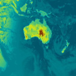
var dataset = ee.ImageCollection('NASA/GSFC/MERRA/rad/2')\n .filter(ee.Filter.date('2022-02-01', '2022-02-02')).first();\nvar surface_albedo = dataset.select('ALBEDO');\nvar saVis = {\n min: -0.428147,\n max: 0.833350,\n palette: ['001137', '01abab', 'e7eb05', '620500']\n};\nMap.setCenter(-95, 39, 2);\nMap.addLayer(surface_albedo, saVis, 'Surface albedo');\n```\n[Open in Code Editor](https://code.earthengine.google.com/?scriptPath=Examples:Datasets/NASA/NASA_GSFC_MERRA_rad_2) \n[MERRA-2 M2T1NXRAD: Radiation Diagnostics V5.12.4](/earth-engine/datasets/catalog/NASA_GSFC_MERRA_rad_2) \nM2T1NXRAD (or tavg1_2d_rad_Nx) is an hourly time-averaged data collection in Modern-Era Retrospective analysis for Research and Applications version 2 (MERRA-2). This collection consists of radiation diagnostics, such as surface albedo, cloud area fraction, in cloud optical thickness, surface incoming shortwave flux (i.e. solar radiation), surface net downward shortwave flux, and ... \nNASA/GSFC/MERRA/rad/2, albedo,atmosphere,climate,emissivity,merra,shortwave,temperature \n1980-01-01T00:00:00Z/2025-08-01T23:00:00Z \n-90 -180 90 180 \nGoogle Earth Engine \nhttps://developers.google.com/earth-engine/datasets\n\n- [](https://doi.org/https://gmao.gsfc.nasa.gov/reanalysis/MERRA-2/)\n- [](https://doi.org/https://developers.google.com/earth-engine/datasets/catalog/NASA_GSFC_MERRA_rad_2)"]]