- ডেটাসেটের প্রাপ্যতা
- 2013-04-11T00:00:00Z–2026-04-19T23:57:26Z
- ডেটাসেট প্রযোজক
- নাসা এলপি ডিএএসি
- ট্যাগ
বর্ণনা
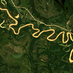
হারমোনাইজড ল্যান্ডস্যাট সেন্টিনেল-২ (HLS) প্রকল্পটি স্যাটেলাইট সেন্সরের একটি ভার্চুয়াল কনস্টেলেশন থেকে ভূপৃষ্ঠের প্রতিফলন (SR) এবং বায়ুমণ্ডলের শীর্ষের (TOA) উজ্জ্বলতার সামঞ্জস্যপূর্ণ ডেটা সরবরাহ করে। অপারেশনাল ল্যান্ড ইমেজার (OLI) নাসা/ইউএসজিএস-এর যৌথ ল্যান্ডস্যাট ৮ এবং ল্যান্ডস্যাট ৯ স্যাটেলাইটে স্থাপন করা হয়েছে, অন্যদিকে মাল্টি-স্পেকট্রাল ইন্সট্রুমেন্ট (MSI) ইউরোপের কোপারনিকাস সেন্টিনেল-২এ এবং সেন্টিনেল-২বি স্যাটেলাইটে বসানো হয়েছে। এই সম্মিলিত পরিমাপ প্রতি ২ থেকে ৩ দিনে ৩০ মিটার স্থানিক রেজোলিউশনে ভূমির বৈশ্বিক পর্যবেক্ষণ সম্ভব করে তোলে। HLS প্রকল্পটি OLI এবং MSI থেকে ত্রুটিহীন ডেটা পাওয়ার জন্য একগুচ্ছ অ্যালগরিদম ব্যবহার করে, যার মধ্যে রয়েছে বায়ুমণ্ডলীয় সংশোধন, মেঘ ও মেঘের ছায়া মাস্কিং, স্থানিক সহ-নিবন্ধন ও সাধারণ গ্রিডিং, আলোকসজ্জা ও দর্শন কোণ স্বাভাবিকীকরণ এবং স্পেকট্রাল ব্যান্ডপাস সমন্বয়।
এইচএলএস প্রকল্পটি দুটি পৃথক পণ্য হিসেবে ডেটা বিতরণ করে: এইচএলএসএল৩০ (ল্যান্ডস্যাট ৮/৯) এবং এইচএলএসএস৩০ (সেন্টিনেল-২ এ/বি)। উভয়ই ৩০ মিটার নাদির দ্বি-দিকনির্ভর প্রতিফলন বণ্টন ফাংশন (বিআরডিএফ) এবং সমন্বিত প্রতিফলন (এনবিএআর) প্রদান করে।
নথিপত্র:
ব্যান্ড
ব্যান্ড
পিক্সেল সাইজ: ৩০ মিটার (সকল ব্যান্ড)
| নাম | ইউনিট | পিক্সেল আকার | বর্ণনা | ||||||||||||||||||||||||||||||||||||||||||||||||||||||||||||||||||||||||||||||||||||||||||||||||
|---|---|---|---|---|---|---|---|---|---|---|---|---|---|---|---|---|---|---|---|---|---|---|---|---|---|---|---|---|---|---|---|---|---|---|---|---|---|---|---|---|---|---|---|---|---|---|---|---|---|---|---|---|---|---|---|---|---|---|---|---|---|---|---|---|---|---|---|---|---|---|---|---|---|---|---|---|---|---|---|---|---|---|---|---|---|---|---|---|---|---|---|---|---|---|---|---|---|---|---|
B1 | ৩০ মিটার | উপকূলীয় অ্যারোসল | |||||||||||||||||||||||||||||||||||||||||||||||||||||||||||||||||||||||||||||||||||||||||||||||||
B2 | ৩০ মিটার | নীল | |||||||||||||||||||||||||||||||||||||||||||||||||||||||||||||||||||||||||||||||||||||||||||||||||
B3 | ৩০ মিটার | সবুজ | |||||||||||||||||||||||||||||||||||||||||||||||||||||||||||||||||||||||||||||||||||||||||||||||||
B4 | ৩০ মিটার | লাল | |||||||||||||||||||||||||||||||||||||||||||||||||||||||||||||||||||||||||||||||||||||||||||||||||
B5 | ৩০ মিটার | এনআইআর | |||||||||||||||||||||||||||||||||||||||||||||||||||||||||||||||||||||||||||||||||||||||||||||||||
B6 | ৩০ মিটার | SWIR1 | |||||||||||||||||||||||||||||||||||||||||||||||||||||||||||||||||||||||||||||||||||||||||||||||||
B7 | ৩০ মিটার | SWIR2 | |||||||||||||||||||||||||||||||||||||||||||||||||||||||||||||||||||||||||||||||||||||||||||||||||
B9 | ৩০ মিটার | সিরাস | |||||||||||||||||||||||||||||||||||||||||||||||||||||||||||||||||||||||||||||||||||||||||||||||||
B10 | ৩০ মিটার | TIRS1 | |||||||||||||||||||||||||||||||||||||||||||||||||||||||||||||||||||||||||||||||||||||||||||||||||
B11 | ৩০ মিটার | TIRS2 | |||||||||||||||||||||||||||||||||||||||||||||||||||||||||||||||||||||||||||||||||||||||||||||||||
Fmask | ৩০ মিটার | কোয়ালিটি বিটস | |||||||||||||||||||||||||||||||||||||||||||||||||||||||||||||||||||||||||||||||||||||||||||||||||
SZA | ডিগ্রি | ৩০ মিটার | সূর্য জেনিথ কোণ | ||||||||||||||||||||||||||||||||||||||||||||||||||||||||||||||||||||||||||||||||||||||||||||||||
SAA | ডিগ্রি | ৩০ মিটার | সূর্যের অ্যাজিমুথ কোণ | ||||||||||||||||||||||||||||||||||||||||||||||||||||||||||||||||||||||||||||||||||||||||||||||||
VZA | ডিগ্রি | ৩০ মিটার | জেনিথ অ্যাঙ্গেল দেখুন | ||||||||||||||||||||||||||||||||||||||||||||||||||||||||||||||||||||||||||||||||||||||||||||||||
VAA | ডিগ্রি | ৩০ মিটার | অ্যাজিমুথ কোণ দেখুন | ||||||||||||||||||||||||||||||||||||||||||||||||||||||||||||||||||||||||||||||||||||||||||||||||
ছবির বৈশিষ্ট্য
ছবির বৈশিষ্ট্য
| নাম | প্রকার | বর্ণনা |
|---|---|---|
| ACCODE | স্ট্রিং | LaSRC সংস্করণ, যেমন LaSRCS2AV3.5.5 অথবা LaSRCL8V3.5.5 |
| ল্যান্ডস্যাট_প্রোডাক্ট_আইডি | স্ট্রিং | ব্যাকট্রেসিং প্রক্রিয়াকরণের জন্য ল্যান্ডস্যাট-৮ ইনপুট এল১ সিন প্রোডাক্ট আইডি। |
| TIRS_SSM_MODEL | স্ট্রিং | TIRS SSM এনকোডার পজিশন মডেল (প্রাথমিক, চূড়ান্ত বা প্রকৃত)। |
| TIRS_SSM_POSITION_STATUS | স্ট্রিং | এল৩০ |
| ইউএসজিএস_সফটওয়্যার | স্ট্রিং | এলপিজিএস_২.৬.২ |
| ক্লাউড কভারেজ | ডাবল | Fmask-এর উপর ভিত্তি করে পর্যবেক্ষণে মেঘ এবং মেঘের ছায়ার শতাংশ |
| HLS_প্রসেসিং_টাইম | স্ট্রিং | এই পর্যবেক্ষণের জন্য এইচএলএস প্রক্রিয়াকরণের তারিখ এবং সময় |
| গড়_সূর্যের_অ্যাজিমুথ_কোণ | ডাবল | HLS L30-এর জন্য ইনপুট ডেটার গড় সূর্য অ্যাজিমুথ কোণ (ডিগ্রিতে) |
| গড়_সূর্যের_শীর্ষ_কোণ | ডাবল | HLS L30-এর জন্য ইনপুট ডেটার গড় সূর্য জেনিথ কোণ (ডিগ্রিতে) |
| গড়_দর্শন_আজিমুথ_কোণ | ডাবল | ইনপুট ডেটার গড় দর্শন অ্যাজিমুথ কোণ (ডিগ্রিতে) |
| গড়_দৃশ্য_শীর্ষ_কোণ | ডাবল | ইনপুট ডেটার গড় দর্শন জেনিথ কোণ (ডিগ্রিতে) |
| NBAR_SOLAR_ZENITH | ডাবল | NBAR প্রতিপাদনে ব্যবহৃত সৌর জেনিথ কোণ |
| স্থানিক_কভারেজ | ডাবল | ডেটা সহ টাইলটির শতাংশ |
ব্যবহারের শর্তাবলী
ব্যবহারের শর্তাবলী
নাসা গবেষণা ও প্রয়োগকারী মহল, বেসরকারি শিল্প, শিক্ষাঙ্গন এবং সাধারণ জনগণের সাথে সকল ডেটার পূর্ণ ও উন্মুক্ত আদান-প্রদানকে উৎসাহিত করে।
উদ্ধৃতি
মাসেক, জে., জু, জে., রজার, জে., স্কাকুন, এস., ভার্মোট, ই., ক্লেভারি, এম., ডানগান, জে., ইন, জেড., ফ্রেইটাগ, বি., জাস্টিস, সি. (২০২১)। এইচএলএস অপারেশনাল ল্যান্ড ইমেজার সারফেস রিফ্লেক্টেন্স অ্যান্ড টিওএ ব্রাইটনেস ডেইলি গ্লোবাল ৩০মি ভি২.০ [ডেটা সেট]। নাসা ইওএসডিআইএস ল্যান্ড প্রসেসেস ডিস্ট্রিবিউটেড অ্যাক্টিভ আর্কাইভ সেন্টার। ২০২৩-০৯-১২ তারিখে https://doi.org/10.5067/HLS/HLSL30.002 থেকে সংগৃহীত।
DOI
আর্থ ইঞ্জিন দিয়ে অন্বেষণ করুন
কোড এডিটর (জাভাস্ক্রিপ্ট)
var collection = ee.ImageCollection("NASA/HLS/HLSL30/v002")
                    .filter(ee.Filter.date('2013-04-25', '2013-04-28'))
                    .filter(ee.Filter.lt('CLOUD_COVERAGE', 30));
var visParams = {
  bands: ['B4', 'B3', 'B2'],
  min:0.01,
  max:0.18,
};

var visualizeImage = function(image) {
  var imageRGB = image.visualize(visParams);
  return imageRGB;
};

var rgbCollection = collection.map(visualizeImage);

Map.setCenter(-60.1765, -22.5318, 11)
Map.addLayer(rgbCollection, {}, 'HLS RGB bands');