- Dostępność zbioru danych
- 2013-04-11T00:00:00Z–2026-07-12T23:56:43Z
- Dostawca zbioru danych
- NASA LP DAAC
- Tagi
Opis
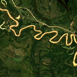
Projekt Harmonized Landsat Sentinel-2 (HLS) dostarcza spójne dane dotyczące odbicia światła słonecznego od powierzchni i jasności w szczycie atmosfery z wirtualnej konstelacji czujników satelitarnych. Instrument Operational Land Imager (OLI) znajduje się na pokładzie satelitów Landsat 8 i Landsat 9, które są wspólnym projektem NASA i USGS, a instrument Multi-Spectral Instrument (MSI) jest zamontowany na pokładzie europejskich satelitów Copernicus Sentinel-2A i Sentinel-2B. Połączone pomiary umożliwiają globalne obserwacje powierzchni Ziemi co 2–3 dni w rozdzielczości przestrzennej 30 m. Projekt HLS wykorzystuje zestaw algorytmów do uzyskiwania spójnych produktów z instrumentów OLI i MSI, które obejmują korekcję atmosferyczną, maskowanie chmur i cieni chmur, przestrzenną korejestrację i wspólne siatki, normalizację oświetlenia i kąta widzenia oraz dostosowanie pasma spektralnego.
Projekt HLS rozpowszechnia dane w postaci 2 osobnych produktów: HLSL30 (Landsat 8/9) i HLSS30 (Sentinel-2 A/B). Oba produkty zapewniają 30-metrową dwukierunkową funkcję rozkładu odbicia (BRDF) w punkcie nadiru i skorygowane odbicie (NBAR).
Dokumentacja:
Pasma
Pasma
Rozmiar piksela: 30 m (wszystkie pasma)
| Nazwa | Jednostki | Rozmiar piksela | Opis | ||||||||||||||||||||||||||||||||||||||||||||||||||||||||||||||||||||||||||||||||||||||||||||||||
|---|---|---|---|---|---|---|---|---|---|---|---|---|---|---|---|---|---|---|---|---|---|---|---|---|---|---|---|---|---|---|---|---|---|---|---|---|---|---|---|---|---|---|---|---|---|---|---|---|---|---|---|---|---|---|---|---|---|---|---|---|---|---|---|---|---|---|---|---|---|---|---|---|---|---|---|---|---|---|---|---|---|---|---|---|---|---|---|---|---|---|---|---|---|---|---|---|---|---|---|
B1 |
30 metrów | Pasmo aerozoli przybrzeżnych |
|||||||||||||||||||||||||||||||||||||||||||||||||||||||||||||||||||||||||||||||||||||||||||||||||
B2 |
30 metrów | Niebieski |
|||||||||||||||||||||||||||||||||||||||||||||||||||||||||||||||||||||||||||||||||||||||||||||||||
B3 |
30 metrów | Zielony |
|||||||||||||||||||||||||||||||||||||||||||||||||||||||||||||||||||||||||||||||||||||||||||||||||
B4 |
30 metrów | Czerwony |
|||||||||||||||||||||||||||||||||||||||||||||||||||||||||||||||||||||||||||||||||||||||||||||||||
B5 |
30 metrów | NIR |
|||||||||||||||||||||||||||||||||||||||||||||||||||||||||||||||||||||||||||||||||||||||||||||||||
B6 |
30 metrów | SWIR1 |
|||||||||||||||||||||||||||||||||||||||||||||||||||||||||||||||||||||||||||||||||||||||||||||||||
B7 |
30 metrów | SWIR2 |
|||||||||||||||||||||||||||||||||||||||||||||||||||||||||||||||||||||||||||||||||||||||||||||||||
B9 |
30 metrów | Cirrus |
|||||||||||||||||||||||||||||||||||||||||||||||||||||||||||||||||||||||||||||||||||||||||||||||||
B10 |
30 metrów | TIRS1 |
|||||||||||||||||||||||||||||||||||||||||||||||||||||||||||||||||||||||||||||||||||||||||||||||||
B11 |
30 metrów | TIRS2 |
|||||||||||||||||||||||||||||||||||||||||||||||||||||||||||||||||||||||||||||||||||||||||||||||||
Fmask |
30 metrów | Fragmenty wysokiej jakości |
|||||||||||||||||||||||||||||||||||||||||||||||||||||||||||||||||||||||||||||||||||||||||||||||||
SZA |
deg | 30 metrów | Kąt zenitu słonecznego |
||||||||||||||||||||||||||||||||||||||||||||||||||||||||||||||||||||||||||||||||||||||||||||||||
SAA |
deg | 30 metrów | Kąt azymutu Słońca |
||||||||||||||||||||||||||||||||||||||||||||||||||||||||||||||||||||||||||||||||||||||||||||||||
VZA |
deg | 30 metrów | Wyświetlanie kąta zenitalnego |
||||||||||||||||||||||||||||||||||||||||||||||||||||||||||||||||||||||||||||||||||||||||||||||||
VAA |
deg | 30 metrów | Wyświetlanie kąta azymutu |
||||||||||||||||||||||||||||||||||||||||||||||||||||||||||||||||||||||||||||||||||||||||||||||||
Właściwości obrazu
Właściwości obrazu
| Nazwa | Typ | Opis |
|---|---|---|
| ACCODE | CIĄG ZNAKÓW | Wersja LaSRC, np. LaSRCS2AV3.5.5 lub LaSRCL8V3.5.5 |
| LANDSAT_PRODUCT_ID | CIĄG ZNAKÓW | Identyfikator produktu sceny wejściowej L1 Landsat-8 do przetwarzania śledzenia wstecznego. |
| TIRS_SSM_MODEL | CIĄG ZNAKÓW | Model pozycji kodera TIRS SSM (wstępny, ostateczny lub rzeczywisty). |
| TIRS_SSM_POSITION_STATUS | CIĄG ZNAKÓW | L30 |
| USGS_SOFTWARE | CIĄG ZNAKÓW | LPGS_2.6.2 |
| CLOUD_COVERAGE | LICZBA ZMIENNOPRZECINKOWA O PODWÓJNEJ PRECYZJI | Procent chmur i cieni chmur w obserwacji na podstawie Fmask |
| HLS_PROCESSING_TIME | CIĄG ZNAKÓW | Data i godzina przetwarzania HLS dla tej obserwacji; |
| MEAN_SUN_AZIMUTH_ANGLE | LICZBA ZMIENNOPRZECINKOWA O PODWÓJNEJ PRECYZJI | Średni kąt azymutalny słońca w stopniach w danych wejściowych dla HLS L30 |
| MEAN_SUN_ZENITH_ANGLE | LICZBA ZMIENNOPRZECINKOWA O PODWÓJNEJ PRECYZJI | Średni kąt zenitalny słońca w stopniach danych wejściowych dla HLS L30 |
| MEAN_VIEW_AZIMUTH_ANGLE | LICZBA ZMIENNOPRZECINKOWA O PODWÓJNEJ PRECYZJI | Średni kąt azymutalny obserwacji w stopniach dla danych wejściowych |
| MEAN_VIEW_ZENITH_ANGLE | LICZBA ZMIENNOPRZECINKOWA O PODWÓJNEJ PRECYZJI | Średni kąt zenitalny obserwacji w stopniach w danych wejściowych |
| NBAR_SOLAR_ZENITH | LICZBA ZMIENNOPRZECINKOWA O PODWÓJNEJ PRECYZJI | Kąt zenitalny Słońca użyty do obliczenia NBAR. |
| SPATIAL_COVERAGE | LICZBA ZMIENNOPRZECINKOWA O PODWÓJNEJ PRECYZJI | Procent kafelka z danymi |
Warunki korzystania z usługi
Warunki korzystania z usługi
NASA promuje pełne i otwarte udostępnianie wszystkich danych społecznościom badawczym i związanym z aplikacją, sektorowi prywatnemu, środowisku akademickiemu i ogółowi społeczeństwa.
Cytowanie
Masek, J., Ju, J., Roger, J., Skakun, S., Vermote, E., Claverie, M., Dungan, J., Yin, Z., Freitag, B., Justice, C. (2021). HLS Operational Land Imager Surface Reflectance and TOA Brightness Daily Global 30m v2.0 [Zbiór danych]. NASA EOSDIS Land Processes Distributed Active Archive Center. Dostęp: 12 września 2023 r. na stronie https://doi.org/10.5067/HLS/HLSL30.002
DOI
Odkrywaj za pomocą Earth Engine
Edytor kodu (JavaScript)
var collection = ee.ImageCollection("NASA/HLS/HLSL30/v002")
                    .filter(ee.Filter.date('2013-04-25', '2013-04-28'))
                    .filter(ee.Filter.lt('CLOUD_COVERAGE', 30));
var visParams = {
  bands: ['B4', 'B3', 'B2'],
  min:0.01,
  max:0.18,
};

var visualizeImage = function(image) {
  var imageRGB = image.visualize(visParams);
  return imageRGB;
};

var rgbCollection = collection.map(visualizeImage);

Map.setCenter(-60.1765, -22.5318, 11)
Map.addLayer(rgbCollection, {}, 'HLS RGB bands');