- ডেটাসেটের প্রাপ্যতা
- 2000-01-01T00:00:00Z-2015-01-01T00:00:00Z
- ডেটাসেট প্রযোজক
- USGS EROS সেন্টারে NASA LP DAAC
- ক্যাডেন্স
- ৫ বছর
- ট্যাগ
বর্ণনা
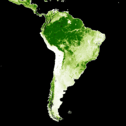
ল্যান্ডস্যাট ভেজিটেশন কন্টিনিউয়াস ফিল্ডস (VCF) বৃক্ষ আচ্ছাদন স্তরগুলিতে প্রতিটি ৩০-মিটার পিক্সেলের অনুভূমিক ভূমির শতকরা হার অন্তর্ভুক্ত থাকে, যা ৫ মিটারের বেশি উচ্চতার কাষ্ঠল উদ্ভিদ দ্বারা আবৃত। এই ডেটাসেটটি ২০০০, ২০০৫, ২০১০ এবং ২০১৫ সালকে কেন্দ্র করে চারটি সময়কালের জন্য উপলব্ধ। ডেটাসেটটি GFCC সারফেস রিফ্লেক্টেন্স প্রোডাক্ট (GFCC30SR) থেকে উদ্ভূত, যা উন্নত গ্লোবাল ল্যান্ড সার্ভে (GLS) ডেটাসেটের উপর ভিত্তি করে তৈরি। GLS ডেটাসেটগুলি ৩০ মিটার রেজোলিউশনের উচ্চ-রেজোলিউশন ল্যান্ডস্যাট ৫ থিমেটিক ম্যাপার (TM) এবং ল্যান্ডস্যাট ৭ এনহ্যান্সড থিমেটিক ম্যাপার প্লাস (ETM+) চিত্র দ্বারা গঠিত।
বৃক্ষ আচ্ছাদন, যা একটি নির্দিষ্ট উচ্চতার উপরে কাষ্ঠল উদ্ভিদের (পাতা, কাণ্ড, শাখা ইত্যাদি সহ) আনুপাতিক, উল্লম্বভাবে প্রক্ষিপ্ত এলাকা, তা স্থলজ শক্তি ও জল বিনিময়, সালোকসংশ্লেষণ ও বাষ্পমোচন, মোট প্রাথমিক উৎপাদন এবং কার্বন ও পুষ্টি প্রবাহকে প্রভাবিত করে। বৃক্ষ আচ্ছাদন বন্যপ্রাণীর আবাসস্থলের গুণমান ও চলাচল, মানুষের জন্য আবাসিক সম্পত্তির মূল্য এবং অন্যান্য বাস্তুতান্ত্রিক পরিষেবাকেও প্রভাবিত করে। VCF পণ্যের অবিচ্ছিন্ন শ্রেণিবিন্যাস পদ্ধতি প্রচলিত বিচ্ছিন্ন শ্রেণিবিন্যাস পদ্ধতির চেয়ে ভূমি আচ্ছাদনের তারতম্যকে আরও ভালোভাবে চিত্রিত করতে সক্ষম। বনের পরিবর্তন (যেমন, বন উজাড় এবং অবক্ষয়) শনাক্তকরণ ও পর্যবেক্ষণের জন্য গুরুত্বপূর্ণ হলো, বৃক্ষ আচ্ছাদন একটি পরিমাপযোগ্য বৈশিষ্ট্য প্রদান করে যার উপর ভিত্তি করে বন আচ্ছাদন এবং এর পরিবর্তনসমূহকে সংজ্ঞায়িত করা যায়। সময়ের সাথে সাথে বৃক্ষ আচ্ছাদনের পরিবর্তন ব্যবহার করে স্থান-নির্দিষ্ট বন পরিবর্তনের ইতিহাস পর্যবেক্ষণ ও পুনরুদ্ধার করা যেতে পারে।
ডেটাসেটটি ২০০০, ২০০৫, ২০১০ এবং ২০১৫—এই চারটি বছরের সময়কালের জন্য তৈরি করা হয়েছে এবং এতে প্রতিটি উপলব্ধ WRS2 পাথ/সারি-র জন্য একটি করে ছবি রয়েছে।
নথিপত্র:
প্রদানকারীর বিজ্ঞপ্তি: NASA MEaSUREs তহবিলের অর্থায়ন বন্ধ হয়ে যাওয়ার কারণে, এই ডেটাসেটের বিনামূল্যের সংস্করণ আর তৈরি করা হচ্ছে না। আগ্রহী পক্ষগণ www.terraPulse.com থেকে এর হালনাগাদ ও বর্ধিত সংস্করণ সংগ্রহ করতে পারেন।
ব্যান্ড
ব্যান্ড
পিক্সেল সাইজ: ৩০ মিটার (সকল ব্যান্ড)
| নাম | ইউনিট | মিনিট | ম্যাক্স | পিক্সেল আকার | বর্ণনা |
|---|---|---|---|---|---|
tree_canopy_cover | % | 0 | ১০০ | ৩০ মিটার | পিক্সেল এলাকার যে শতাংশ গাছ দ্বারা আবৃত। |
uncertainty | ৩০ মিটার | গাছের ছাউনির আচ্ছাদনের জন্য RMSE | |||
source_index | ৩০ মিটার | নির্দিষ্ট পিক্সেলের জন্য ব্যবহৃত উৎস ছবির পরিচয়। এটি প্রতিটি ছবির মেটাডেটা অ্যারে 'sources'-এর একটি সূচক। শুধুমাত্র ২০০০, ২০০৫ এবং ২০১০ সংস্করণের জন্য উপলব্ধ। |
ছবির বৈশিষ্ট্য
ছবির বৈশিষ্ট্য
| নাম | প্রকার | বর্ণনা |
|---|---|---|
| পথ | ডাবল | পথ |
| পাথর | স্ট্রিং | পথ এবং সারি |
| সারি | ডাবল | সারি |
| উৎস | ডাবল | উৎসসমূহ। শুধুমাত্র ২০০০, ২০০৫ এবং ২০১০ সালের জন্য উপলব্ধ। |
| গাছের_ছত্র_আচ্ছাদন_শ্রেণী_প্যালেট | ডাবল | গাছের ছাউনির আচ্ছাদন শ্রেণীর প্যালেট |
| গাছের ছাউনির আচ্ছাদনের শ্রেণী মান | ডাবল | গাছের ছাউনির আচ্ছাদনের শ্রেণী মান |
| বছর | ডাবল | বছর |
ব্যবহারের শর্তাবলী
ব্যবহারের শর্তাবলী
এই ডেটাসেটের মেধাস্বত্ব মেরিল্যান্ড বিশ্ববিদ্যালয়ের ভৌগোলিক বিজ্ঞান বিভাগ এবং নাসার মালিকানাধীন। স্বীকৃতি প্রদান সাপেক্ষে এর ব্যবহার বিনামূল্যে।
উদ্ধৃতি
গবেষণাপত্র/পদ্ধতির উদ্ধৃতি: সেক্সটন, জেও, সং, এক্স.-পি., ফেং, এম., নুজিপাডি, পি., আনন্দ, এ., হুয়াং, সি., কিম, ডি.-এইচ., কলিন্স, কেএম, চান্নান, এস., ডিমিচেলি, সি., টাউনশেন্ড, জেআরজি (২০১৩)। বৈশ্বিক, ৩০-মিটার রেজোলিউশনের বৃক্ষ আচ্ছাদনের অবিচ্ছিন্ন ক্ষেত্র: লিডার-ভিত্তিক ত্রুটির অনুমান সহ মোডিস ভেজিটেশন কন্টিনিউয়াস ফিল্ডস-এর ল্যান্ডস্যাট-ভিত্তিক পুনঃস্কেলিং। ইন্টারন্যাশনাল জার্নাল অফ ডিজিটাল আর্থ, 130321031236007। doi:10.1080/17538947.2013.786146 ।
DOI
আর্থ ইঞ্জিন দিয়ে অন্বেষণ করুন
কোড এডিটর (জাভাস্ক্রিপ্ট)
var dataset = ee.ImageCollection('NASA/MEASURES/GFCC/TC/v3')
                  .filter(ee.Filter.date('2015-01-01', '2015-12-31'));
var treeCanopyCover = dataset.select('tree_canopy_cover');
var treeCanopyCoverVis = {
  min: 0.0,
  max: 100.0,
  palette: ['ffffff', 'afce56', '5f9c00', '0e6a00', '003800'],
};
Map.setCenter(-88.6, 26.4, 3);
Map.addLayer(treeCanopyCover.mean(), treeCanopyCoverVis, 'Tree Canopy Cover');