- Disponibilidade de conjuntos de dados
- 2010-01-01T00:00:00Z–2010-12-31T00:00:00Z
- Provedor de conjunto de dados
- NASA ORNL DAAC no Laboratório Nacional de Oak Ridge
- Cadência
- 1 ano
- Tags
Descrição
Esse conjunto de dados fornece mapas globais consistentes e harmonizados no tempo da densidade de carbono da biomassa acima e abaixo do solo para o ano de 2010 com uma resolução espacial de 300 m. O mapa de biomassa acima do solo integra mapas específicos de cobertura da terra, detectados remotamente, de biomassa de floresta, pastagem, lavoura e tundra. Os mapas de entrada foram reunidos da literatura publicada e, quando necessário, atualizados para abranger a extensão focal ou o período. O mapa de biomassa subterrânea integra mapas correspondentes derivados de cada mapa de biomassa acima do solo e modelos empíricos específicos de cobertura da terra. Os mapas acima e abaixo do solo foram integrados separadamente usando mapas auxiliares de porcentagem de cobertura de árvores e cobertura do solo e uma árvore de decisão baseada em regras. Também são fornecidos mapas que mostram a incerteza acumulada das estimativas no nível do pixel.
Observação do provedor: o conjunto de dados de biomassa de carbono do Centro Mundial de Monitoramento da Conservação (WCMC, na sigla em inglês) do Programa das Nações Unidas para o Meio Ambiente (PNUMA) representa condições entre 1982 e 2010, dependendo do tipo de cobertura da terra. Os padrões relativos dos estoques de carbono são bem representados com esse conjunto de dados. O conjunto de dados de biomassa de carbono da NASA/ORNL representa as condições de biomassa para 2010, com estimativas de incerteza no nível do pixel. A biomassa adicional de tipos de cobertura da terra não dominantes é representada em cada pixel. Para mais informações, consulte os artigos que descrevem cada conjunto de dados: WCMC (Soto-Navarro et al. 2020) e NASA/ORNL (Spawn et al. 2020).
Bandas
Tamanho do pixel
300 metros
Bandas
| Nome | Unidades | Mín. | Máx. | Tamanho do pixel | Descrição |
|---|---|---|---|---|---|
agb |
Mg/ha | 0* | 129* | metros | Densidade de estoque de carbono da biomassa viva acima do solo da cobertura combinada de plantas lenhosas e herbáceas em 2010. Isso inclui o carbono armazenado em tecidos vegetais vivos localizados acima da superfície da Terra (caules, cascas, galhos, gravetos). Isso não inclui serapilheira ou detritos lenhosos grossos que já estiveram presos a plantas vivas, mas foram depositados e não estão mais vivos. |
agb_uncertainty |
Mg/ha | 0* | 85* | metros | Incerteza da densidade de carbono estimada da biomassa viva acima do solo da cobertura combinada de plantas lenhosas e herbáceas em 2010. A incerteza representa o erro padrão cumulativo que foi propagado pelo processo de harmonização usando a soma em quadratura. |
bgb |
Mg/ha | 0* | 57* | metros | Densidade de estoque de carbono da biomassa viva subterrânea da cobertura combinada de plantas lenhosas e herbáceas em 2010. Isso inclui o carbono armazenado em tecidos vegetais vivos localizados abaixo da superfície da Terra (raízes). Isso não inclui tecido radicular morto e/ou deslocado, nem matéria orgânica do solo. |
bgb_uncertainty |
Mg/ha | 0* | 37* | metros | Incerteza da densidade de carbono estimada da biomassa viva subterrânea da cobertura lenhosa e herbácea combinada em 2010. A incerteza representa o erro padrão cumulativo que foi propagado pelo processo de harmonização usando a soma em quadratura. |
Termos de Uso
Termos de Uso
Esse conjunto de dados está em domínio público e disponível sem restrições de uso e distribuição. Consulte a Política de dados e informações de ciências da Terra da NASA para mais informações.
Citações
Spawn, S.A., Sullivan, C.C., Lark, T.J. et al. Harmonized global maps of above and belowground biomass carbon density in the year 2010. Sci Data 7, 112 (2020). doi:10.1038/s41597-020-0444-4
Spawn, S.A., e H.K. Gibbs. 2020. Mapas globais de densidade de carbono da biomassa acima e abaixo do solo para o ano de 2010. ORNL DAAC, Oak Ridge, Tennessee, EUA.
DOIs
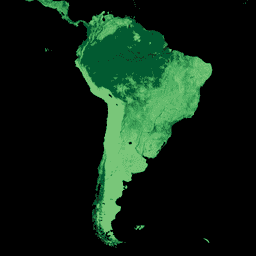
Explorar com o Earth Engine
Editor de código (JavaScript)
var dataset = ee.ImageCollection('NASA/ORNL/biomass_carbon_density/v1');

var visualization = {
  bands: ['agb'],
  min: -50.0,
  max: 80.0,
  palette: ['d9f0a3', 'addd8e', '78c679', '41ab5d', '238443', '005a32']
};

Map.setCenter(-60.0, 7.0, 4);

Map.addLayer(dataset, visualization, 'Aboveground biomass carbon');