- Disponibilidade de conjuntos de dados
- 2015-04-02T12:00:00Z–2022-08-02T12:00:00Z
- Provedor de conjunto de dados
- NASA GSFC
- Cadência
- 3 dias
- Tags
Descrição
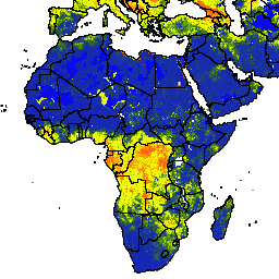
Os dados globais de umidade do solo do SMAP aprimorado da NASA-USDA fornecem informações sobre a umidade do solo em todo o mundo com resolução espacial de 10 km. Esse conjunto de dados inclui: superfície, subsuperfície, umidade do solo (mm), perfil de umidade do solo (%), anomalias de umidade do solo na superfície e na subsuperfície (-).
O conjunto de dados é gerado pela integração de observações de umidade do solo de nível 3 do programa SMAP (Soil Moisture Active Passive, na sigla em inglês) derivadas de satélite no modelo de Palmer modificado de duas camadas usando uma abordagem de assimilação de dados de filtro de Kalman de conjunto (EnKF) unidimensional. As anomalias de umidade do solo foram calculadas com base na climatologia do dia de interesse. A climatologia foi estimada com base no registro completo de dados da observação do satélite SMAP e na abordagem de janela móvel centralizada de 31 dias. A assimilação das observações de umidade do solo do SMAP ajuda a melhorar as previsões de umidade do solo baseadas em modelos, principalmente em áreas mal instrumentadas do mundo que não têm dados de precipitação de boa qualidade.
Esse conjunto de dados foi desenvolvido pelo Laboratório de Ciências Hidrológicas do Goddard Space Flight Center da NASA em cooperação com os Serviços Agrícolas Estrangeiros do USDA e o Laboratório de Hidrologia e Sensoriamento Remoto do USDA.
Bandas
Tamanho do pixel
10.000 metros
Bandas
| Nome | Unidades | Mín. | Máx. | Tamanho do pixel | Descrição |
|---|---|---|---|---|---|
ssm |
mm | 0* | 25.39* | metros | Umidade da superfície do solo |
susm |
mm | 0* | 274,6* | metros | Umidade do solo abaixo da superfície |
smp |
Fração | 0* | 1* | metros | Perfil de umidade do solo |
ssma |
Sem dimensão | -4* | 4* | metros | Anomalia de umidade da superfície do solo |
susma |
Sem dimensão | -4* | 4* | metros | Anomalia de umidade do solo abaixo da superfície |
Termos de Uso
Termos de Uso
Esse conjunto de dados está em domínio público e disponível sem restrições de uso e distribuição. Consulte a Política de dados e informações de ciências da Terra da NASA para mais informações.
Citações
Sazib, N., J. D. Bolten e I. E. Mladenova. 2021. Uso do NASA Soil Moisture Active Passive para avaliar a suscetibilidade a incêndios e os possíveis impactos na Austrália e na Califórnia. IEEE Journal of Selected Topics in Applied Earth Observations and Remote Sensing, 15: 779-787. doi:10.1109/jstars.2021.3136756
Mladenova, I.E., Bolten, J.D., Crow, W., Sazib, N. e Reynolds, C., 2020. Monitoramento da seca agrícola pela assimilação de recuperações de umidade do solo do SMAP em um modelo global de balanço hídrico do solo. Front. Big Data, 3(10). doi:10.3389/fdata.2020.00010
Sazib, N., J. D. Bolten e I. E. Mladenova. 2021. Uso do NASA Soil Moisture Active Passive para avaliar a suscetibilidade a incêndios e os possíveis impactos na Austrália e na Califórnia. IEEE Journal of Selected Topics in Applied Earth Observations and Remote Sensing, 15: 779-787. doi:10.1109/jstars.2021.3136756
Mladenova, I.E., Bolten, J.D., Crow, W.T., Sazib, N., Cosh, M.H., Tucker, C.J. and Reynolds, C., 2019. Avaliação da aplicação operacional do SMAP para o monitoramento global da seca agrícola. IEEE Journal of Selected Topics in Applied Earth Observations and Remote Sensing, 12(9): 3387-3397. doi:10.1109/JSTARS.2019.2923555
Sazib, N., Mladenova, I., e Bolten, J. (2020). Avaliação do impacto do ENOS na agricultura da África usando dados de observação da Terra. Frontiers in Sustainable Food Systems, 4, 188. doi:10.3389/fsufs.2020.509914 Google Scholar
Sazib, N., Mladenova, I. e Bolten, J., 2018. Aproveitar o Google Earth Engine para avaliação de seca usando dados globais de umidade do solo. Remote sensing, 10(8): 1265. doi:10.3390/rs10081265
Bolten, J., W.T. Crow, X. Zhan, T.J. Jackson e C.A. Reynolds (2010). Evaluating the Utility of Remotely Sensed Soil Moisture Retrievals for Operational Agricultural Drought Monitoring, IEEE Transactions on Geoscience and Remote Sensing, 3(1): 57-66. doi:10.1109/JSTARS.2009.2037163 Google Scholar
Bolten, J., and W. T. Crow (2012). Improved prediction of quasi-global vegetation conditions using remotely sensed surface soil moisture, Geophysical Research Letters, 39: (L19406). [doi:10.1029/2012GL053470][https://doi.org/10.1029/2012GL053470) Google Acadêmico
Entekhabi, D, Njoku, EG, O'Neill, PE, Kellogg, KH, Crow, WT, Edelstein, WN, Entin, JK, Goodman, SD, Jackson, TJ, Johnson, J, Kimball, J, Piepmeier, JR, Koster, RD, Martin, N, McDonald, KC, Moghaddam, M, Moran, S, Reichle, R, Shi, JC, Spencer, MW, Thurman, SW, Tsang, L & Van Zyl, J (2010). The soil moisture active passive (SMAP) mission, Proceedings of the IEEE, 98(5): 704-716. doi:10.1109/JPROC.2010.2043918
I. E. Mladenova, J.D. Bolten, W.T. Crow, M.C. Anderson, C.R. Hain, D.M. Johnson, R. Mueller (2017). Intercomparação de umidade do solo, estresse evaporativo e índices de vegetação para estimar a produção de milho e soja nos EUA, IEEE Journal of Selected Topics in Applied Earth Observations and Remote Sensing, 10(4): 1328-1343. doi:10.1109/JSTARS.2016.2639338
O'Neill, P. E., S. Chan, E. G. Njoku, T. Jackson, and R. Bindlish (2016). SMAP L3 Radiometer Global Daily 36 km EASE-Grid Soil Moisture, Version 4. Boulder, Colorado, EUA. National Snow and Ice Data Center / Distributed Active Archive Center da NASA.doi:10.5067/ZX7YX2Y2LHEB
DOIs
- https://doi.org/10.1029/2012GL053470
- https://doi.org/10.1109/JPROC.2010.2043918
- https://doi.org/10.1109/JSTARS.2009.2037163
- https://doi.org/10.1109/JSTARS.2016.2639338
- https://doi.org/10.1109/JSTARS.2019.2923555
- https://doi.org/10.1109/jstars.2021.3136756
- https://doi.org/10.3389/fsufs.2020.509914
- https://doi.org/10.3390/rs10081265
- https://doi.org/10.5067/ZX7YX2Y2LHEB
Explorar com o Earth Engine
Editor de código (JavaScript)
var dataset = ee.ImageCollection('NASA_USDA/HSL/SMAP10KM_soil_moisture')
                  .filter(ee.Filter.date('2017-04-01', '2017-04-30'));
var soilMoisture = dataset.select('ssm');
var soilMoistureVis = {
  min: 0.0,
  max: 28.0,
  palette: ['0300ff', '418504', 'efff07', 'efff07', 'ff0303'],
};
Map.setCenter(-6.746, 46.529, 2);
Map.addLayer(soilMoisture, soilMoistureVis, 'Soil Moisture');