O produto de dados de índices de vegetação (VNP13A1) do Visible Infrared Imaging Radiometer Suite (VIIRS) da NASA (Suomi National Polar-Orbiting Partnership, S-NPP) fornece índices de vegetação por um processo de seleção do melhor pixel disponível em um período de aquisição de 16 dias com resolução de 500 metros. Os produtos de dados VNP13 foram projetados com base na suíte de produtos de índices de vegetação Terra e Aqua do espectrorradiômetro de imagens de resolução moderada (MODIS) para promover a continuidade da missão do Sistema de Observação da Terra (EOS).
O processo do algoritmo VNP13 produz três índices de vegetação: (1) Índice de Vegetação por Diferença Normalizada (NDVI), (2) Índice de Vegetação Aprimorado (EVI) e (3) Índice de Vegetação Aprimorado-2 (EVI2).
(1) O NDVI é uma das observações de série temporal contínuas mais longas de sensoriamento remoto, usando as bandas vermelha e infravermelha próxima (NIR).
(2) O EVI é um índice de vegetação ligeiramente diferente, mais sensível à cobertura da copa, enquanto o NDVI é mais sensível à clorofila. (3) O EVI2 é uma reformulação do EVI padrão de três bandas, usando as bandas vermelha e NIR. Essa reformulação aborda problemas que surgem ao comparar o EVI do VIIRS com outros modelos de EVI que não incluem uma banda azul. O EVI2
vai se tornar o EVI padrão.
Além das três camadas de índices de vegetação, esse produto também inclui camadas de refletância de infravermelho próximo (NIR), três refletâncias de infravermelho de ondas curtas (SWIR) (vermelha, azul e verde), dia do ano composto, confiabilidade de pixel, ângulos de visão e de sol e uma camada de qualidade.
Reflectância de radiação infravermelha de ondas curtas
SWIR2_reflectance
metros
1580-1640nm
Reflectância de radiação infravermelha de ondas curtas
SWIR3_reflectance
metros
2225-2275nm
Reflectância de radiação infravermelha de ondas curtas
VI_Quality
metros
Nenhum
Campo de bits de avaliação de qualidade (QA, na sigla em inglês).
Bitmask para VI_Quality
Bits 0-1: MODLAND_QA
0: VI produzido, boa qualidade
1: VI produzido, mas verifique outros controles de qualidade
2: Pixel produzido, mas provavelmente nublado
3: Pixel não produzido por outro motivo que não sejam nuvens
Bits 2 a 5: utilidade do VI. Valores mais altos são piores.
0: Melhor qualidade
1: qualidade mais baixa
2: Qualidade decrescente
3: qualidade decrescente
4: qualidade decrescente
5: qualidade decrescente
6: Qualidade decrescente
7: Qualidade decrescente
8: Qualidade decrescente
9: Qualidade decrescente
10: qualidade decrescente
11: Qualidade decrescente
12: pior qualidade
13: Qualidade tão baixa que não é útil
14: Dados L1B com falha
15: Não é útil por nenhum motivo/não foi processado
Bits 6-7: quantidade de aerossol
0: Climatologia
1: baixa
2: média
3: alta
Bit 8: nuvem adjacente detectada
0: Não
1: Sim
Bit 9: correção de BRDF adjacente realizada
0: Não
1: Sim
Bit 10: Mixed clouds
0: Não
1: Sim
Bits 11 a 13: flagra de terra/água
0: terra e deserto
1: terra sem deserto
2: água doce
3: sea_water
5: costeira
Bit 14: possível neve/gelo
0: Não
1: Sim
Bit 15: possível sombra
0: Não
1: Sim
red_reflectance
metros
600 a 680 nm
Reflectância da banda vermelha
green_reflectance
metros
545 a 656 nm
Refletância da banda verde
blue_reflectance
metros
478-498nm
Reflectância da banda azul
composite_day_of_the_year
d
metros
Nenhum
Dia juliano do ano
pixel_reliability
metros
Nenhum
Utilidade do Pixel usando uma classe de classificação simples
relative_azimuth_angle
graus
metros
Nenhum
Ângulo de azimute relativo para cada pixel
sun_zenith_angle
graus
metros
Nenhum
Ângulo de azimute solar para cada pixel
view_zenith_angle
graus
metros
Nenhum
Ver o ângulo zenital de cada pixel
Tabela de classes pixel_reliability
Valor
Cor
Descrição
0
Nenhum
Excelente
1
Nenhum
Boa
2
Nenhum
Aceitável
3
Nenhum
Marginal
4
Nenhum
Aprovado
5
Nenhum
Questionável
6
Nenhum
Ruim
7
Nenhum
Sombra de nuvem
8
Nenhum
Neve/gelo
9
Nenhum
Cloud
10
Nenhum
Estimativa
11
Nenhum
LTAVG (extraído do banco de dados)
Termos de Uso
Termos de Uso
Os dados da NASA do LP DAAC são de livre acesso. No entanto, quando um autor publica esses dados ou trabalhos baseados neles, é necessário citar os conjuntos de dados no texto da publicação e incluir uma referência a eles na lista de referências.
O produto de dados de índices de vegetação (VNP13A1) do Visible Infrared Imaging Radiometer Suite (VIIRS) da NASA da Suomi National Polar-Orbiting Partnership (S-NPP) fornece índices de vegetação por um processo de seleção do melhor pixel disponível em um período de aquisição de 16 dias com resolução de 500 metros. Os produtos de dados VNP13 são projetados após o Moderate Resolution Imaging …
[null,null,[],[[["\u003cp\u003eThe NASA VIIRS VNP13A1 dataset provides vegetation indices (NDVI, EVI, EVI2) and reflectance data at 500m resolution over 16-day periods.\u003c/p\u003e\n"],["\u003cp\u003eThis dataset, available from 2012-01-17 to 2024-11-24, is designed for continuity with MODIS vegetation indices products.\u003c/p\u003e\n"],["\u003cp\u003eVNP13A1 includes quality assessment layers for pixel reliability, view and sun angles, and potential cloud or snow/ice presence.\u003c/p\u003e\n"],["\u003cp\u003eThe dataset is freely accessible through NASA LP DAAC and is easily integrated into Google Earth Engine for analysis.\u003c/p\u003e\n"],["\u003cp\u003eUsers are requested to cite the dataset appropriately in publications using data derived from this product.\u003c/p\u003e\n"]]],[],null,["Dataset Availability\n: 2012-01-17T00:00:00Z--2025-08-05T00:00:00Z\n\nDataset Provider\n:\n\n\n [NASA LP DAAC at the USGS EROS Center](https://doi.org/10.5067/VIIRS/VNP13A1.002)\n\nCadence\n: 8 Days\n\nTags\n:\n [16-day](/earth-engine/datasets/tags/16-day) [evi](/earth-engine/datasets/tags/evi) [nasa](/earth-engine/datasets/tags/nasa) [ndvi](/earth-engine/datasets/tags/ndvi) [noaa](/earth-engine/datasets/tags/noaa) [npp](/earth-engine/datasets/tags/npp) [vegetation](/earth-engine/datasets/tags/vegetation) [vegetation-indices](/earth-engine/datasets/tags/vegetation-indices) [viirs](/earth-engine/datasets/tags/viirs) \nvnp13a1 \n\nDescription \nThe Suomi National Polar-Orbiting Partnership (S-NPP) NASA Visible\nInfrared Imaging Radiometer Suite (VIIRS) Vegetation Indices (VNP13A1)\ndata product provides vegetation indices by a process of\nselecting the best available pixel over a 16-day acquisition period\nat 500 meter resolution. The VNP13 data products are designed\nafter the Moderate Resolution Imaging Spectroradiometer (MODIS)\nTerra and Aqua Vegetation Indices product suite to promote the\ncontinuity of the Earth Observation System (EOS) mission.\n\nThe VNP13 algorithm process produces three vegetation indices: (1)\nNormalized Difference Vegetation Index (NDVI), (2) the Enhanced\nVegetation Index (EVI), and (3) Enhanced Vegetation Index-2 (EVI2).\n(1) NDVI is one of the longest continual remotely sensed time series\nobservations, using both the red and near-infrared (NIR) bands.\n(2) EVI is a slightly different vegetation index that is more sensitive\nto canopy cover, while NDVI is more sensitive to chlorophyll. (3) EVI2\nis a reformation of the standard 3-band EVI, using the red band and\nNIR band. This reformation addresses arising issues when comparing\nVIIRS EVI to other EVI models that do not include a blue band. EVI2\nwill eventually become the standard EVI.\n\nAlong with the three Vegetation Indices layers, this product also\nincludes layers for near-infrared (NIR) reflectance; three shortwave\ninfrared (SWIR) reflectance-red, blue, and green reflectance; composite\nday of year; pixel reliability; view and sun angles, and a quality layer.\n\nFor additional information, visit the VIIRS [Land Product Quality\nAssessment website](https://landweb.modaps.eosdis.nasa.gov/browse?sensor=VIIRS&sat=SNPP) and see\nthe [User Guide](https://lpdaac.usgs.gov/documents/1372/VNP13_User_Guide_ATBD_V2.1.2.pdf).\n\nDocumentation:\n\n- [General Documentation](https://ladsweb.modaps.eosdis.nasa.gov/filespec/VIIRS/1/VNP13A1)\n\nBands\n\n\n**Pixel Size**\n\n500 meters\n\n**Bands**\n\n| Name | Units | Pixel Size | Wavelength | Description |\n|-----------------------------|-------|------------|-------------|--------------------------------------------|---|---|---|---|---|---|---|---|---|---|---|---|---|---|---|---|---|---|---|---|---|---|---|---|---|---|---|---|---|---|---|---|---|---|---|---|---|---|---|---|---|---|---|---|---|---|---|---|---|---|---|---|---|---|---|---|---|---|---|---|---|---|---|---|---|---|---|---|---|---|---|---|---|---|---|---|---|---|---|---|---|---|---|---|---|---|---|---|---|---|---|---|---|---|---|\n| `EVI` | | meters | None | 3 band Enhanced Vegetation Index |\n| `EVI2` | | meters | None | 2 band Enhanced Vegetation Index |\n| `NDVI` | | meters | None | Normalized Difference Vegetation Index |\n| `NIR_reflectance` | | meters | 846-885nm | Near-infrared Radiation reflectance |\n| `SWIR1_reflectance` | | meters | 1230-1250nm | Shortwave Infrared Radiation reflectance |\n| `SWIR2_reflectance` | | meters | 1580-1640nm | Shortwave Infrared Radiation reflectance |\n| `SWIR3_reflectance` | | meters | 2225-2275nm | Shortwave Infrared Radiation reflectance |\n| `VI_Quality` | | meters | None | Quality Assessment (QA) bit-field. |\n| Bitmask for VI_Quality - Bits 0-1: MODLAND_QA - 0: VI produced, good quality - 1: VI produced, but check other QA - 2: Pixel produced, but probably cloudy - 3: Pixel not produced due to other reason than clouds - Bits 2-5: VI Usefulness, higher values are worse. - 0: Highest Quality - 1: Lower quality - 2: Decreasing quality - 3: Decreasing quality - 4: Decreasing quality - 5: Decreasing quality - 6: Decreasing quality - 7: Decreasing quality - 8: Decreasing quality - 9: Decreasing quality - 10: Decreasing quality - 11: Decreasing quality - 12: Worst quality - 13: Quality so low that it is not useful - 14: L1B data faulty - 15: Not useful for any reason/not processed - Bits 6-7: Aerosol quantity - 0: Climatology - 1: Low - 2: Average - 3: High - Bit 8: Adjacent cloud detected - 0: No - 1: Yes - Bit 9: Adjacent BRDF correction performed - 0: No - 1: Yes - Bit 10: Mixed clouds - 0: No - 1: Yes - Bits 11-13: Land/Water Flag - 0: land \\& desert - 1: land no desert - 2: inland water - 3: sea_water - 5: coastal - Bit 14: Possible snow/ice - 0: No - 1: Yes - Bit 15: Possible shadow - 0: No - 1: Yes ||||||||||||||||||||||||||||||||||||||||||||||||||||||||||||||||||||||||||||||||||||||||||||||||||||\n| `red_reflectance` | | meters | 600-680nm | Red band reflectance |\n| `green_reflectance` | | meters | 545-656nm | Green band reflectance |\n| `blue_reflectance` | | meters | 478-498nm | Blue band reflectance |\n| `composite_day_of_the_year` | d | meters | None | Julian day of year |\n| `pixel_reliability` | | meters | None | Pixel usefulness using a simple rank class |\n| `relative_azimuth_angle` | deg | meters | None | Relative azimuth angle for each pixel |\n| `sun_zenith_angle` | deg | meters | None | Sun zenith angle for each pixel |\n| `view_zenith_angle` | deg | meters | None | View zenith angle for each pixel |\n\n**pixel_reliability Class Table**\n\n| Value | Color | Description |\n|-------|-------|-----------------------------|\n| 0 | None | Excellent |\n| 1 | None | Good |\n| 2 | None | Acceptable |\n| 3 | None | Marginal |\n| 4 | None | Pass |\n| 5 | None | Questionable |\n| 6 | None | Poor |\n| 7 | None | Cloud Shadow |\n| 8 | None | Snow/Ice |\n| 9 | None | Cloud |\n| 10 | None | Estimated |\n| 11 | None | LTAVG (taken from database) |\n\nTerms of Use\n\n**Terms of Use**\n\nLP DAAC NASA data are freely accessible; however, when an author\npublishes these data or works based on the data, it is requested that the\nauthor cite the datasets within the text of the publication and include a\nreference to them in the reference list.\n\nCitations \nCitations:\n\n- Please visit [LP DAAC 'Citing Our Data' page](https://lpdaac.usgs.gov/citing_our_data)\n for information on citing LP DAAC datasets.\n\nDOIs\n\n- \u003chttps://doi.org/10.5067/VIIRS/VNP13A1.002\u003e\n\nExplore with Earth Engine **Important:** Earth Engine is a platform for petabyte-scale scientific analysis and visualization of geospatial datasets, both for public benefit and for business and government users. Earth Engine is free to use for research, education, and nonprofit use. To get started, please [register for Earth Engine access.](https://console.cloud.google.com/earth-engine)\n\nCode Editor (JavaScript) \n\n```javascript\n
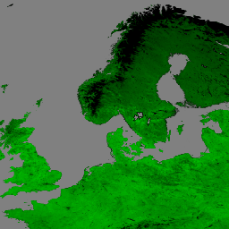
var dataset = ee.ImageCollection('NASA/VIIRS/002/VNP13A1')\n .filter(ee.Filter.date('2017-05-01', '2017-06-30'));\nvar rgb = dataset.select(['EVI']);\nvar rgbVis = {\n min: 0.0,\n max: 1.0,\n palette: ['000000', '004400', '008800', '00bb00', '00ff00'],\n};\nMap.setCenter(17.93, 7.71, 6);\nMap.addLayer(rgb, rgbVis, 'RGB');\n```\n[Open in Code Editor](https://code.earthengine.google.com/?scriptPath=Examples:Datasets/NASA/NASA_VIIRS_002_VNP13A1) \n[VNP13A1.002: VIIRS Vegetation Indices 16-Day 500m](/earth-engine/datasets/catalog/NASA_VIIRS_002_VNP13A1) \nThe Suomi National Polar-Orbiting Partnership (S-NPP) NASA Visible Infrared Imaging Radiometer Suite (VIIRS) Vegetation Indices (VNP13A1) data product provides vegetation indices by a process of selecting the best available pixel over a 16-day acquisition period at 500 meter resolution. The VNP13 data products are designed after the Moderate Resolution Imaging ... \nNASA/VIIRS/002/VNP13A1, 16-day,evi,nasa,ndvi,noaa,npp,vegetation,vegetation-indices,viirs \n2012-01-17T00:00:00Z/2025-08-05T00:00:00Z \n-90 -180 90 180 \nGoogle Earth Engine \nhttps://developers.google.com/earth-engine/datasets\n\n- [https://doi.org/10.5067/VIIRS/VNP13A1.002](https://doi.org/https://doi.org/10.5067/VIIRS/VNP13A1.002)\n- [https://doi.org/10.5067/VIIRS/VNP13A1.002](https://doi.org/https://developers.google.com/earth-engine/datasets/catalog/NASA_VIIRS_002_VNP13A1)"]]