- ডেটাসেটের উপলভ্যতা
- ২০১২-০১-১৭T০০:০০:০০Z–২০২৫-১২-২৭T০০:০০:০০Z
- ডেটাসেট প্রদানকারী
- USGS EROS সেন্টারে NASA LP DAAC
- ক্যাডেন্স
- ৮ দিন
- ট্যাগ
বিবরণ
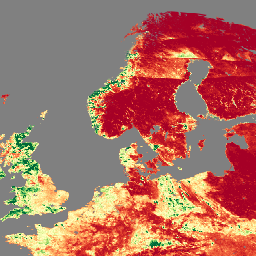
ভিজিবল ইনফ্রারেড ইমেজিং রেডিওমিটার স্যুট (VIIRS) লিফ এরিয়া ইনডেক্স (LAI) এবং ফ্র্যাকশন অফ সালোকসংশ্লেষণমূলকভাবে সক্রিয় বিকিরণ (FPAR) সংস্করণ 1 ডেটা প্রোডাক্ট 500 মিটার রেজোলিউশনে (VNP15A2H) ভেজিটেবল ক্যানোপি স্তর সম্পর্কে তথ্য প্রদান করে। VIIRS সেন্সরটি NOAA/NASA যৌথ সুওমি ন্যাশনাল পোলার-অরবিটিং পার্টনারশিপ (সুওমি NPP) স্যাটেলাইটে অবস্থিত। LAI হল একটি সূচক যা একটি ক্যানোপির একতরফা পাতার ক্ষেত্রফল পরিমাপ করে, অন্যদিকে FPAR হল 400 থেকে 700 ন্যানোমিটারে সালোকসংশ্লেষণের মাধ্যমে শোষিত আগত সৌরশক্তির ভগ্নাংশ। এই প্রোডাক্টটি ইচ্ছাকৃতভাবে টেরা এবং অ্যাকোয়া মডারেট রেজোলিউশন ইমেজিং স্পেকট্রোরেডিওমিটার (MODIS) LAI/FPAR অপারেশনাল অ্যালগরিদম অনুসরণ করে তৈরি করা হয়েছে যাতে আর্থ অবজারভেশন সিস্টেম (EOS) মিশনের ধারাবাহিকতা বৃদ্ধি পায়।
ডকুমেন্টেশন:
ব্যান্ড
পিক্সেল আকার
৫০০ মিটার
ব্যান্ড
| নাম | ইউনিট | পিক্সেল আকার | বিবরণ | ||||||||||||||||||||||||||||||||||||||||||||||||||||||||||||||||||||||||||||||||||||||||||||||||
|---|---|---|---|---|---|---|---|---|---|---|---|---|---|---|---|---|---|---|---|---|---|---|---|---|---|---|---|---|---|---|---|---|---|---|---|---|---|---|---|---|---|---|---|---|---|---|---|---|---|---|---|---|---|---|---|---|---|---|---|---|---|---|---|---|---|---|---|---|---|---|---|---|---|---|---|---|---|---|---|---|---|---|---|---|---|---|---|---|---|---|---|---|---|---|---|---|---|---|---|
Fpar | মিটার | সালোকসংশ্লেষণগতভাবে সক্রিয় বিকিরণের ভগ্নাংশ। | |||||||||||||||||||||||||||||||||||||||||||||||||||||||||||||||||||||||||||||||||||||||||||||||||
FparExtra_QC | মিটার | FPAR-এর জন্য পাস-থ্রু কোয়ালিটি কন্ট্রোল (QC) | |||||||||||||||||||||||||||||||||||||||||||||||||||||||||||||||||||||||||||||||||||||||||||||||||
FparLai_QC | মিটার | LAI এবং FPAR এর জন্য গুণমান | |||||||||||||||||||||||||||||||||||||||||||||||||||||||||||||||||||||||||||||||||||||||||||||||||
FparStdDev | মিটার | FPAR এর স্ট্যান্ডার্ড বিচ্যুতি | |||||||||||||||||||||||||||||||||||||||||||||||||||||||||||||||||||||||||||||||||||||||||||||||||
Lai | ক্ষেত্রফল ভগ্নাংশ | মিটার | পাতার ক্ষেত্রফল সূচক | ||||||||||||||||||||||||||||||||||||||||||||||||||||||||||||||||||||||||||||||||||||||||||||||||
LaiStdDev | ক্ষেত্রফল ভগ্নাংশ | মিটার | LAI-এর জন্য আদর্শ বিচ্যুতি | ||||||||||||||||||||||||||||||||||||||||||||||||||||||||||||||||||||||||||||||||||||||||||||||||
ব্যবহারের শর্তাবলী
ব্যবহারের শর্তাবলী
LP DAAC NASA ডেটা অবাধে অ্যাক্সেসযোগ্য; তবে, যখন কোনও লেখক এই ডেটা প্রকাশ করেন বা ডেটার উপর ভিত্তি করে কাজ করেন, তখন লেখককে অনুরোধ করা হয় যে তিনি প্রকাশনার পাঠ্যের মধ্যে ডেটাসেটগুলি উদ্ধৃত করুন এবং রেফারেন্স তালিকায় তাদের একটি রেফারেন্স অন্তর্ভুক্ত করুন।
উদ্ধৃতি
ডিওআই
আর্থ ইঞ্জিনের সাহায্যে ঘুরে দেখুন
কোড এডিটর (জাভাস্ক্রিপ্ট)
var dataset = ee.ImageCollection('NASA/VIIRS/002/VNP15A2H')
                  .filter(ee.Filter.date('2022-11-01', '2022-12-01'));

var visualization = {
  bands: ['Lai'],
  min: [0],
  max: [4],
  palette: [
    'a50026',
    'd73027',
    'f46d43',
    'fdae61',
    'fee08b',
    'ffffbf',
    'd9ef8b',
    'a6d96a',
    '66bd63',
    '1a9850',
    '006837',
  ]
};
Map.setCenter(41.2, 38.84, 3);
Map.addLayer(dataset, visualization, 'Leaf Area Index (LAI)');