- Доступность набора данных
- 2012-01-17T00:00:00Z–2025-12-19T00:00:00Z
- Поставщик наборов данных
- НАСА LP DAAC в Центре EROS Геологической службы США
- Каденция
- 8 дней
- Теги
Описание
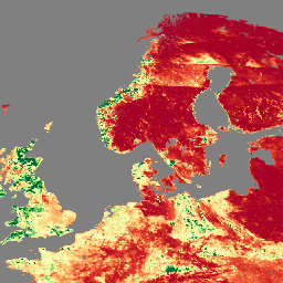
Продукт Visible Infrared Imaging Radiometer Suite (VIIRS) — данные индекса листовой поверхности (LAI) и доли фотосинтетически активного излучения (FPAR) версии 1 — предоставляет информацию о растительном покрове с разрешением 500 метров (VNP15A2H). Датчик VIIRS расположен на борту спутника Suomi National Polar-Orbiting Partnership (Suomi NPP), созданного совместно NOAA и NASA. LAI — это индекс, количественно определяющий одностороннюю площадь листьев растительного покрова, а FPAR — это доля поступающей солнечной энергии, поглощаемой в процессе фотосинтеза на длинах волн от 400 до 700 нанометров. Этот продукт специально разработан на основе алгоритма работы LAI/FPAR спектрорадиометра среднего разрешения Terra и Aqua (MODIS) для обеспечения непрерывности миссии Earth Observation System (EOS).
Документация:
Группы
Размер пикселя
500 метров
Группы
| Имя | Единицы | Размер пикселя | Описание | ||||||||||||||||||||||||||||||||||||||||||||||||||||||||||||||||||||||||||||||||||||||||||||||||
|---|---|---|---|---|---|---|---|---|---|---|---|---|---|---|---|---|---|---|---|---|---|---|---|---|---|---|---|---|---|---|---|---|---|---|---|---|---|---|---|---|---|---|---|---|---|---|---|---|---|---|---|---|---|---|---|---|---|---|---|---|---|---|---|---|---|---|---|---|---|---|---|---|---|---|---|---|---|---|---|---|---|---|---|---|---|---|---|---|---|---|---|---|---|---|---|---|---|---|---|
Fpar | метры | Доля фотосинтетически активного излучения. | |||||||||||||||||||||||||||||||||||||||||||||||||||||||||||||||||||||||||||||||||||||||||||||||||
FparExtra_QC | метры | Промежуточный контроль качества (КК) для FPAR | |||||||||||||||||||||||||||||||||||||||||||||||||||||||||||||||||||||||||||||||||||||||||||||||||
FparLai_QC | метры | Качество для LAI и FPAR | |||||||||||||||||||||||||||||||||||||||||||||||||||||||||||||||||||||||||||||||||||||||||||||||||
FparStdDev | метры | Стандартное отклонение FPAR | |||||||||||||||||||||||||||||||||||||||||||||||||||||||||||||||||||||||||||||||||||||||||||||||||
Lai | Доля площади | метры | Индекс листовой поверхности | ||||||||||||||||||||||||||||||||||||||||||||||||||||||||||||||||||||||||||||||||||||||||||||||||
LaiStdDev | Доля площади | метры | Стандартное отклонение для LAI | ||||||||||||||||||||||||||||||||||||||||||||||||||||||||||||||||||||||||||||||||||||||||||||||||
Условия эксплуатации
Условия эксплуатации
Данные LP DAAC NASA находятся в свободном доступе; однако, если автор публикует эти данные или работает на их основе, ему рекомендуется цитировать наборы данных в тексте публикации и включать ссылку на них в список литературы.
Цитаты
Пожалуйста, посетите страницу LP DAAC «Цитирование наших данных» для получения информации о цитировании наборов данных LP DAAC.
DOI
Исследуйте мир с помощью Earth Engine.
Редактор кода (JavaScript)
var dataset = ee.ImageCollection('NASA/VIIRS/002/VNP15A2H')
                  .filter(ee.Filter.date('2022-11-01', '2022-12-01'));

var visualization = {
  bands: ['Lai'],
  min: [0],
  max: [4],
  palette: [
    'a50026',
    'd73027',
    'f46d43',
    'fdae61',
    'fee08b',
    'ffffbf',
    'd9ef8b',
    'a6d96a',
    '66bd63',
    '1a9850',
    '006837',
  ]
};
Map.setCenter(41.2, 38.84, 3);
Map.addLayer(dataset, visualization, 'Leaf Area Index (LAI)');