- 数据集可用时间
- 2012-01-17T00:00:00Z–2026-05-23T00:00:00Z
- 数据集生产者
- 美国地质调查局地球资源观测与科学中心下属的美国国家航空航天局陆地过程分布式主动存档中心
- 时间分辨率
- 1 天
- 标签
说明
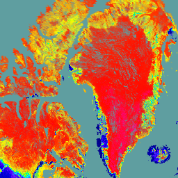
NASA/NOAA Suomi 国家极轨伙伴卫星 (Suomi NPP) 可见光红外成像辐射仪套件 (VIIRS) 天底双向反射分布函数 (BRDF) 调整反射率 (NBAR) 第 2 版产品以 500 米的分辨率提供 NBAR 估计值。VNP43IA4 产品每天使用 16 天的 VIIRS 数据生成,并在时间维度上加权至第 9 天,这一信息体现在文件名中。方向反射率中消除了视角效应,从而生成稳定一致的 NBAR 产品。VNP43 数据产品旨在促进 NASA 中分辨率成像光谱仪 (MODIS) BRDF/反照率数据产品套件的连续性。
VNP43 算法使用 RossThick/Li-Sparse-Reciprocal (RTLSR) 半经验核驱动 BRDF 模型,并使用 VNP43IA1 中的三个核权重来重建地表各向异性效应,将方向反射率校正为通用视角几何图形 (VNP43IA4),同时计算地方太阳正午时分的综合黑空反照率 (BSA) 和白空反照率 (WSA) (VNP43IA3)。研究人员可以使用 BRDF 模型参数和简单的多项式,在任何太阳照明角度下获得黑空反照率。同样,BSA 和 WSA 科学数据集 (SDS) 层都可以与简单的多项式一起使用,以手动估计瞬时实际反照率(蓝空反照率)。如需了解有关该方法的更多详细信息,请参阅算法理论基础文档 (ATBD)。
文档:
频段
频段
像素大小:500 米(所有频段)
| 名称 | 像元大小 | 说明 |
|---|---|---|
BRDF_Albedo_Band_Mandatory_Quality_I1 |
500 米 | 频段 I1 的 BRDF/反照率强制质量 |
BRDF_Albedo_Band_Mandatory_Quality_I2 |
500 米 | 频段 I2 的 BRDF/反照率强制质量 |
BRDF_Albedo_Band_Mandatory_Quality_I3 |
500 米 | 频段 I3 的 BRDF/反照率强制质量 |
Nadir_Reflectance_I1 |
500 米 | 频段 I1 在地方太阳正午时分的天底 BRDF/反照率反射率 |
Nadir_Reflectance_I2 |
500 米 | 频段 I2 在地方太阳正午时分的天底 BRDF/反照率反射率 |
Nadir_Reflectance_I3 |
500 米 | 频段 I3 在地方太阳正午时分的天底 BRDF/反照率反射率 |
使用条款
使用条款
LP DAAC NASA 数据可免费访问;不过,如果作者发布这些数据或基于这些数据创作作品,则需要在出版物的正文中引用相应数据集,并在引用列表中添加对这些数据集的引用。
引用
Schaaf, C. Z. Wang, A. Erb, I. Paynter. VIIRS/NPP BRDF/Albedo Nadir BRDF-Adjusted Ref Daily L3 Global 500m SIN Grid V002. 2024, distributed by NASA EOSDIS Land Processes Distributed Active Archive Center, 10.5067/VIIRS/VNP43IA4.002.
DOI
通过 Earth Engine 探索
代码编辑器 (JavaScript)
var dataset = ee.ImageCollection('NASA/VIIRS/002/VNP43IA4')
                  .filter(ee.Filter.date('2021-06-01', '2021-06-03'));

var nadir_reflectance_I1 = dataset.select('Nadir_Reflectance_I1').first();
var palette = [
  '000080',
  '0000d9',
  '4000ff',
  '8000ff',
  '0080ff',
  '00ffff',
  '00ff80',
  '80ff00',
  'daff00',
  'ffff00',
  'fff500',
  'ffda00',
  'ffb000',
  'ffa400',
  'ff4f00',
  'ff2500',
  'ff0a00',
  'ff00ff',
];
var visParams = {
  min: 0,
  max: 10000,
  palette: palette,
};

// cadetblue
var background = ee.Image.rgb(95, 158, 160).visualize({min: 0, max: 255});
var image = nadir_reflectance_I1.visualize(visParams);

var lon = -8;
var lat = 60;

Map.addLayer(background, {}, 'background');
Map.addLayer(image, {}, 'Nadir BRDF/Albedo Reflectance I1');
Map.setCenter(lon, lat, 3);