- 데이터 세트 제공
- 2012-01-19T00:00:00Z–2026-01-06T00:00:00Z
- 데이터 세트 제공업체
- NASA LAADS DAAC
- 주기
- 1일
- 태그
설명
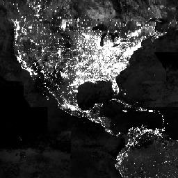
Suomi National Polar-orbiting Partnership (SNPP) Visible Infrared Imaging Radiometer Suite (VIIRS)는 지구 시스템 과학 및 애플리케이션에 적합한 야간 가시광선 및 근적외선 (NIR)의 전역 일일 측정을 제공하는 Day-Night Band(DNB) 센서를 지원합니다. 저조도 조건에서 VIIRS DNB의 초감도를 통해 이전 시대의 국방 기상 위성 프로그램/운영 라인스캔 시스템 (DMSP/OLS)의 야간 조명 이미지 제품과 비교할 때 센서 해상도와 보정에서 상당한 개선을 보여주는 새로운 과학 품질 야간 제품을 생성할 수 있습니다. 이러한 개선을 통해 VIIRS DNB 제품은 야간 현상의 크기와 특징, 인위적인 광원 배출을 더 잘 모니터링할 수 있습니다.
VNP46A2는 VIIRS/NPP Gap-Filled Lunar BRDF-Adjusted Nighttime Lights Daily L3 Global 500m Linear Lat Lon Grid라는 일일 달빛 및 대기 보정 야간 조명 (NTL) 제품의 약칭입니다.
문서:
대역
픽셀 크기
500m
대역
| 이름 | 최소 | 최대 | 픽셀 크기 | 설명 | |||||||||||||||||||||||||||||||||||||||||||||||||||||||||||||||||||||||||||||||||||||||||||||||
|---|---|---|---|---|---|---|---|---|---|---|---|---|---|---|---|---|---|---|---|---|---|---|---|---|---|---|---|---|---|---|---|---|---|---|---|---|---|---|---|---|---|---|---|---|---|---|---|---|---|---|---|---|---|---|---|---|---|---|---|---|---|---|---|---|---|---|---|---|---|---|---|---|---|---|---|---|---|---|---|---|---|---|---|---|---|---|---|---|---|---|---|---|---|---|---|---|---|---|---|
DNB_BRDF_Corrected_NTL |
0 | 6553.4 | 미터 | BRDF 수정 DNB NTL |
|||||||||||||||||||||||||||||||||||||||||||||||||||||||||||||||||||||||||||||||||||||||||||||||
Gap_Filled_DNB_BRDF_Corrected_NTL |
0 | 6553.4 | 미터 | 갭이 채워진 BRDF 수정 DNB NTL |
|||||||||||||||||||||||||||||||||||||||||||||||||||||||||||||||||||||||||||||||||||||||||||||||
DNB_Lunar_Irradiance |
0 | 6553.4 | 미터 | DNB 달빛 조사량 |
|||||||||||||||||||||||||||||||||||||||||||||||||||||||||||||||||||||||||||||||||||||||||||||||
Latest_High_Quality_Retrieval |
미터 | 최신 고품질 BRDF 보정 DNB 복사휘도 검색 |
|||||||||||||||||||||||||||||||||||||||||||||||||||||||||||||||||||||||||||||||||||||||||||||||||
Mandatory_Quality_Flag |
0 | 3 | 미터 | 필수 품질 플래그 |
|||||||||||||||||||||||||||||||||||||||||||||||||||||||||||||||||||||||||||||||||||||||||||||||
Snow_Flag |
0 | 1 | 미터 | 눈 덮임 표시 |
|||||||||||||||||||||||||||||||||||||||||||||||||||||||||||||||||||||||||||||||||||||||||||||||
QF_Cloud_Mask |
미터 | 클라우드 마스크의 품질 플래그 |
|||||||||||||||||||||||||||||||||||||||||||||||||||||||||||||||||||||||||||||||||||||||||||||||||
Mandatory_Quality_Flag 클래스 표
| 값 | 색상 | 설명 |
|---|---|---|
| 0 | 없음 | 고품질의 지속적인 야간 조명 |
| 1 | 없음 | 고품질의 일시적인 야간 조명 |
| 2 | 없음 | 품질이 좋지 않거나, 이상치이거나, 클라우드 오염 가능성이 있거나, 기타 문제가 있음 |
| 255 | 없음 | 검색 없음, 채우기 값 (인제스트 시 마스킹됨) |
Snow_Flag 클래스 테이블
| 값 | 색상 | 설명 |
|---|---|---|
| 0 | 없음 | 눈/얼음 없음 |
| 1 | 없음 | 눈/얼음 |
이용약관
이용약관
LP DAAC NASA 데이터는 자유롭게 액세스할 수 있지만, 저자가 이러한 데이터를 게시하거나 데이터를 기반으로 작업할 때는 저자가 게시물의 텍스트 내에서 데이터 세트를 인용하고 참고 문헌 목록에 데이터 세트에 대한 참조를 포함해야 합니다.
인용
Román, M.O., Wang, Z., Sun, Q., Kalb, V., Miller, S.D., Molthan, A., Schultz, L., Bell, J., Stokes, E.C., Pandey, B. and Seto, K.C., et al. (2018). NASA의 Black Marble 야간 조명 제품군 Remote Sensing of Environment 210, 113~143. 10.1016/j.rse.2018.03.017
DOI
Earth Engine으로 탐색
코드 편집기(JavaScript)
var dataset = ee.ImageCollection('NASA/VIIRS/002/VNP46A2')
                  .filter(ee.Filter.date('2013-01-01', '2013-03-01'));

var nighttime = dataset.select('Gap_Filled_DNB_BRDF_Corrected_NTL');
var nighttimeVis = {min: 0.0, max: 1.0};

Map.setCenter(-77.1056, 38.8904, 3);
Map.addLayer(nighttime, nighttimeVis, 'Nighttime');