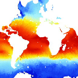
해수면 온도 - WHOI 데이터 세트는 NOAA 해양 표면 번들 (OSB)의 일부이며, 얼음이 없는 해양의 해수면 온도에 관한 고품질 기후 데이터 기록 (CDR)을 제공합니다.
SST 값은 일일 변동성을 해수면 온도에 대한 AVHRR 관측과 결합하여 모델링하여 구합니다.
대역
픽셀 크기 27830미터
대역
이름
단위
최소
최대
픽셀 크기
설명
sea_surface_temperature
°C
-1.79*
35*
미터
일일 온난화 보정이 적용된 최적 보간 해수면 온도 (OISST)
fill_missing_qc
미터
품질 관리 플래그
fill_missing_qc의 비트 마스크
비트 0~2: 품질 관리 플래그
0: 신경망의 픽셀 값
1: 사용되지 않는 플래그
2: 눈/얼음
3: 육지
4: 호수 위
5: SST 누락, SST 미해결
* 예상 최솟값 또는 최댓값
이용약관
이용약관
CDR의 NOAA CDR 프로그램 공식 배포 지점은 NOAA의 국립 기후 데이터 센터입니다. 이 센터는 대통령의 '공개 데이터 정책'에 관한 메모에 설명되어 있고 2013년 5월 9일의 행정 명령 '정부 정보의 새로운 기본값으로 공개 및 기계 판독 가능 설정'에 따라 미국의 공개 데이터 정책 및 관행을 준수하여 CDR 패키지 및 관련 정보에 대한 지속적이고 개방적인 액세스와 적극적인 데이터 관리를 제공합니다. 이러한 정책에 따라 CDR 데이터 세트는 독점적이지 않고 공개적으로 제공되며 사용에 제한이 없습니다. 자세한 내용은 NOAA의 CDR 데이터 세트, 알고리즘, 문서의 공정 사용 PDF를 참고하세요.
인용
인용:
Clayson, Carol Anne, Brown, Jeremiah, NOAA CDR Program (2016). 해수면 온도 - WHOI, 버전 2의 NOAA 기후 데이터 기록 해양 표면 번들 (OSB) 기후 데이터 기록 (CDR) [사용된 하위 집합을 나타냅니다.] NOAA
National Climatic Data Center. doi:10.7289/V5FB510W.
[null,null,[],[[["\u003cp\u003eThe NOAA CDR SST_WHOI/V2 dataset provides a Climate Data Record (CDR) of sea surface temperature over ice-free oceans from 1988 to 2021.\u003c/p\u003e\n"],["\u003cp\u003eThe dataset utilizes a diurnal warming correction model combined with AVHRR observations to derive sea surface temperature values.\u003c/p\u003e\n"],["\u003cp\u003eIt offers global coverage at a 27830-meter resolution and includes quality control flags for data reliability.\u003c/p\u003e\n"],["\u003cp\u003eThis dataset is freely available for research, education, and non-profit use through the Google Earth Engine platform.\u003c/p\u003e\n"],["\u003cp\u003eNOAA's National Climatic Data Center is the official source and distributor, ensuring open access and data management in accordance with US open data policies.\u003c/p\u003e\n"]]],["The NOAA Sea Surface Temperature - WHOI dataset, available from 1988 to 2021 at a 3-hour cadence, provides sea surface temperature (SST) data over ice-free oceans, with diurnal variability modeling and AVHRR observations. The dataset, part of NOAA's Ocean Surface Bundle, offers quality-controlled SST values in Celsius, with pixel sizes of 27830 meters. It can be accessed via Google Earth Engine, using the `ee.ImageCollection(\"NOAA/CDR/SST_WHOI/V2\")` snippet.\n"],null,["# NOAA CDR WHOI: Sea Surface Temperature, Version 2\n\nDataset Availability\n: 1988-01-01T00:00:00Z--2021-08-31T00:00:00Z\n\nDataset Provider\n:\n\n\n [NOAA](https://www.ncei.noaa.gov/products/climate-data-records/sea-surface-temperature-whoi)\n\nCadence\n: 3 Hours\n\nTags\n:\n [atmospheric](/earth-engine/datasets/tags/atmospheric) [cdr](/earth-engine/datasets/tags/cdr) [hourly](/earth-engine/datasets/tags/hourly) [noaa](/earth-engine/datasets/tags/noaa) [ocean](/earth-engine/datasets/tags/ocean) [oceans](/earth-engine/datasets/tags/oceans) [oisst](/earth-engine/datasets/tags/oisst) [osb](/earth-engine/datasets/tags/osb) [sst](/earth-engine/datasets/tags/sst) \nwhoi \n\n#### Description\n\nThe Sea Surface Temperature - WHOI dataset is part of the NOAA Ocean Surface\nBundle (OSB) and provides a high quality Climate Data Record (CDR) of sea\nsurface temperature over ice-free oceans.\n\nThe SST values are found through modeling the diurnal variability in\ncombination with AVHRR observations of sea surface temperature.\n\n### Bands\n\n\n**Pixel Size**\n\n27830 meters\n\n**Bands**\n\n| Name | Units | Min | Max | Pixel Size | Description |\n|---------------------------|-------|---------|------|------------|------------------------------------------------------------------------------------------|---|---|---|---|---|---|---|---|---|---|---|---|---|---|---|---|---|---|---|---|---|---|---|---|---|---|---|---|---|---|---|---|---|---|---|---|---|---|---|---|---|---|---|---|---|---|---|---|---|---|---|---|---|---|---|---|---|---|---|---|---|---|---|---|---|---|---|---|---|---|---|---|---|---|---|---|---|---|---|---|---|---|---|---|---|---|---|---|---|---|---|---|---|---|\n| `sea_surface_temperature` | °C | -1.79\\* | 35\\* | meters | Optimum Interpolation Sea Surface Temperature (OISST), with a diurnal warming correction |\n| `fill_missing_qc` | | | | meters | Quality control flags |\n| Bitmask for fill_missing_qc - Bits 0-2: Quality control flags - 0: Pixel values from neural network - 1: Unused flag - 2: Snow/ice - 3: Over land - 4: Over lake - 5: SST missing, SST unresolved ||||||||||||||||||||||||||||||||||||||||||||||||||||||||||||||||||||||||||||||||||||||||||||||||||||\n\n\\* estimated min or max value\n\n### Terms of Use\n\n**Terms of Use**\n\nThe NOAA CDR Program's official distribution point for CDRs is NOAA's\nNational Climatic Data Center which provides sustained, open access and\nactive data management of the CDR packages and related information in\nkeeping with the United States' open data policies and practices as\ndescribed in the President's Memorandum on \"Open Data Policy\" and pursuant\nto the Executive Order of May 9, 2013, \"Making Open and Machine Readable\nthe New Default for Government Information\". In line with these policies,\nthe CDR data sets are nonproprietary, publicly available, and no\nrestrictions are placed upon their use. For more information, see the\n[Fair Use of NOAA's CDR Data Sets, Algorithms and Documentation](https://www1.ncdc.noaa.gov/pub/data/sds/cdr/CDRs/Aerosol_Optical_Thickness/UseAgreement_01B-04.pdf)\npdf.\n\n### Citations\n\nCitations:\n\n- Clayson, Carol Anne, Brown, Jeremiah, and NOAA CDR Program (2016). NOAA\n Climate Data Record Ocean Surface Bundle (OSB) Climate Data Record (CDR) of\n Sea Surface Temperature - WHOI, Version 2. \\[indicate subset used\\]. NOAA\n National Climatic Data Center. [doi:10.7289/V5FB510W](https://doi.org/10.7289/V5FB510W).\n\n### DOIs\n\n- \u003chttps://doi.org/10.7289/V5FB510W\u003e\n\n### Explore with Earth Engine\n\n| **Important:** Earth Engine is a platform for petabyte-scale scientific analysis and visualization of geospatial datasets, both for public benefit and for business and government users. Earth Engine is free to use for research, education, and nonprofit use. To get started, please [register for Earth Engine access.](https://console.cloud.google.com/earth-engine)\n\n### Code Editor (JavaScript)\n\n```javascript\nvar dataset = ee.ImageCollection('NOAA/CDR/SST_WHOI/V2')\n .filter(ee.Filter.date('2018-03-01', '2018-03-14'));\nvar seaSurfaceTemperature = dataset.select('sea_surface_temperature');\nvar visParams = {\n min: 0.0,\n max: 30.0,\n palette: [\n '040274', '040281', '0502a3', '0502b8', '0502ce', '0502e6',\n '0602ff', '235cb1', '307ef3', '269db1', '30c8e2', '32d3ef',\n '3be285', '3ff38f', '86e26f', '3ae237', 'b5e22e', 'd6e21f',\n 'fff705', 'ffd611', 'ffb613', 'ff8b13', 'ff6e08', 'ff500d',\n 'ff0000', 'de0101', 'c21301', 'a71001', '911003'\n ],\n};\nMap.setCenter(-4.92, -21.09, 2);\nMap.addLayer(seaSurfaceTemperature, visParams, 'Sea Surface Temperature');\n```\n[Open in Code Editor](https://code.earthengine.google.com/?scriptPath=Examples:Datasets/NOAA/NOAA_CDR_SST_WHOI_V2) \n[NOAA CDR WHOI: Sea Surface Temperature, Version 2](/earth-engine/datasets/catalog/NOAA_CDR_SST_WHOI_V2) \nThe Sea Surface Temperature - WHOI dataset is part of the NOAA Ocean Surface Bundle (OSB) and provides a high quality Climate Data Record (CDR) of sea surface temperature over ice-free oceans. The SST values are found through modeling the diurnal variability in combination with AVHRR observations of sea surface ... \nNOAA/CDR/SST_WHOI/V2, atmospheric,cdr,hourly,noaa,ocean,oceans,oisst,osb,sst \n1988-01-01T00:00:00Z/2021-08-31T00:00:00Z \n-90 -180 90 180 \nGoogle Earth Engine \nhttps://developers.google.com/earth-engine/datasets\n\n- [https://doi.org/10.7289/V5FB510W](https://doi.org/https://www.ncei.noaa.gov/products/climate-data-records/sea-surface-temperature-whoi)\n- [https://doi.org/10.7289/V5FB510W](https://doi.org/https://developers.google.com/earth-engine/datasets/catalog/NOAA_CDR_SST_WHOI_V2)"]]