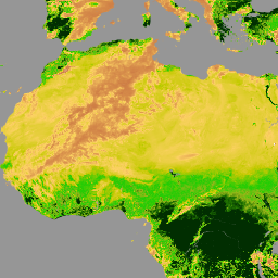
Esse conjunto de dados contém o Índice de Vegetação por Diferença Normalizada (NDVI) diário em grade derivado do Registro de Dados Climáticos (CDR) da NOAA de refletância de superfície do Visible Infrared Imaging Radiometer Suite (VIIRS). O registro de dados abrange de 2014 em diante usando dados de satélites de órbita polar da NOAA. Os dados são projetados em uma grade global de 0,05 grau x 0,05 grau. Esse conjunto de dados é um dos produtos de CDR da superfície terrestre produzidos pelo Centro de Voos Espaciais Goddard (GSFC) da NASA e pela Universidade de Maryland (UMD).
Problemas conhecidos com esse conjunto de dados:
A variável TIMEOFDAY contém valores que são muito grandes em um dia
Os valores de latitude não estão associados corretamente ao centro da célula da grade.O erro é < 0, 002 graus
Os valores de longitude não estão associados corretamente ao centro da célula da grade. O erro é < 0, 02 graus.
Observação do provedor: a deriva orbital do N-19 (o último satélite da NOAA com o sensor AVHRR) começou a degradar muito a qualidade do produto recuperado. Portanto, o VIIRS é agora o sensor principal usado para esses produtos de 2014 até o momento.
Bandas
Tamanho do pixel 5566 metros
Bandas
Nome
Unidades
Mín.
Máx.
Escala
Tamanho do pixel
Descrição
NDVI
-9998*
9998*
0,0001
metros
Índice de vegetação por diferença normalizada
TIMEOFDAY
h
0*
2400*
0,01
metros
Horas desde o início do dia
QA
metros
Flags de bits de controle de qualidade
Máscara de bits para controle de qualidade
Bit 0: não usado
0: Não
1: Sim
Bit 1: o pixel está nublado
0: Não
1: Sim
Bit 2: o pixel contém sombra de nuvem
0: Não
1: Sim
Bit 3: o Pixel está sobre a água
0: Não
1: Sim
Bit 4: Pixel está sobre o brilho do sol
0: Não
1: Sim
Bit 5: o Pixel está sobre vegetação escura densa
0: Não
1: Sim
Bit 6: o Pixel está à noite (alto zênite solar)
0: Não
1: Sim
Bit 7: os canais de 1 a 5 são válidos
0: Não
1: Sim
Bit 8: o valor do canal 1 é inválido
0: Não
1: Sim
Bit 9: o valor do canal 2 é inválido
0: Não
1: Sim
Bit 10: o valor do canal 3 é inválido
0: Não
1: Sim
Bit 11: o valor do canal 4 é inválido
0: Não
1: Sim
Bit 12: o valor do canal 5 é inválido
0: Não
1: Sim
Bit 13: o valor RHO3 é inválido
0: Não
1: Sim
Bit 14: a correção de BRDF é inválida
0: Não
1: Sim
Bit 15: flag polar, latitude acima de 60 graus (terra) ou 50 graus (oceano)
0: Não
1: Sim
* valor mínimo ou máximo estimado
Propriedades da imagem
Nome
Tipo
Descrição
status
STRING
"provisional" ou "permanent"
Termos de Uso
Termos de Uso
O ponto de distribuição oficial do Programa de CDR da NOAA é o Centro Nacional de Dados Climáticos da NOAA, que oferece acesso aberto e sustentado e gerenciamento ativo de dados dos pacotes de CDR e informações relacionadas, de acordo com as políticas e práticas de dados abertos dos Estados Unidos, conforme descrito no Memorando do Presidente sobre "Política de dados abertos" e de acordo com a Ordem Executiva de 9 de maio de 2013, "Tornar abertos e legíveis por máquina o novo padrão para informações governamentais". De acordo com essas políticas, os conjuntos de dados de CDR não são proprietários, estão disponíveis publicamente e não há restrições ao uso deles. Para mais informações, consulte o PDF Uso justo de conjuntos de dados, algoritmos e documentação de CDR da NOAA.
Citações
Citações:
Citação: Vermote, Eric; NOAA CDR Program. (2022): NOAA Climate Data Record
(CDR) of VIIRS Normalized Difference Vegetation Index (NDVI), Version 1.
[indique o subconjunto usado]. NOAA National Centers for Environmental Information.
https://doi.org/10.25921/gakh-st76
Esse conjunto de dados contém o Índice de Vegetação por Diferença Normalizada (NDVI, na sigla em inglês) diário em grade derivado do NOAA Climate Data Record (CDR) de refletância de superfície do Visible Infrared Imaging Radiometer Suite (VIIRS). O registro de dados abrange de 2014 em diante usando dados de satélites de órbita polar da NOAA. Os dados são projetados em uma resolução de 0,05 grau x …
[null,null,[],[[["\u003cp\u003eThis dataset provides daily gridded Normalized Difference Vegetation Index (NDVI) data derived from the NOAA Climate Data Record (CDR) of Visible Infrared Imaging Radiometer Suite (VIIRS) Surface Reflectance.\u003c/p\u003e\n"],["\u003cp\u003eThe data, sourced from NOAA polar-orbiting satellites, spans from January 1, 2014, to January 31, 2025, and is projected on a 0.05-degree global grid.\u003c/p\u003e\n"],["\u003cp\u003eThe dataset includes bands for NDVI, time of day, and quality control, with a pixel size of 5566 meters.\u003c/p\u003e\n"],["\u003cp\u003eKnown issues include inaccuracies in the TIMEOFDAY variable and minor errors in latitude and longitude values related to the grid cell centers.\u003c/p\u003e\n"],["\u003cp\u003eThe data is nonproprietary and publicly accessible, with the primary sensor used being VIIRS since 2014, as outlined by the NOAA CDR Program.\u003c/p\u003e\n"]]],[],null,["Dataset Availability\n: 2014-01-01T00:00:00Z--2025-08-22T00:00:00Z\n\nDataset Provider\n:\n\n\n [NOAA](https://www.ncei.noaa.gov/products/climate-data-records/normalized-difference-vegetation-index)\n\nCadence\n: 1 Day\n\nTags\n:\n[cdr](/earth-engine/datasets/tags/cdr) [daily](/earth-engine/datasets/tags/daily) [land](/earth-engine/datasets/tags/land) [ndvi](/earth-engine/datasets/tags/ndvi) [noaa](/earth-engine/datasets/tags/noaa) [vegetation-indices](/earth-engine/datasets/tags/vegetation-indices) [viirs](/earth-engine/datasets/tags/viirs) \n\nDescription \nThis dataset contains gridded daily Normalized Difference Vegetation Index\n(NDVI) derived from the NOAA Climate Data Record (CDR) of Visible Infrared\nImaging Radiometer Suite (VIIRS) Surface Reflectance. The data record spans\nfrom 2014 onward using data from NOAA polar orbiting\nsatellites. The data are projected on a 0.05 degree x 0.05 degree global\ngrid. This dataset is one of the Land Surface CDR products produced by the\nNASA Goddard Space Flight Center (GSFC) and the University of Maryland\n(UMD).\n\nKnown issues with this dataset include:\n\n- TIMEOFDAY variable contains values that are too large by 1 day\n\n- Latitude values are not correctly associated with the center of\n the grid cell, error is \\\u003c 0.002 degrees\n\n- Longitude values are not correctly associated with the center of\n the grid cell, error is \\\u003c 0.02 degrees\n\nSee [technical note from the data provider](https://www.ncei.noaa.gov/pub/data/sds/cdr/CDRs/Normalized_Difference_Vegetation_Index/VIIRS/AlgorithmDescriptionVIIRS_01B-20b.pdf).\n\nProvider's note: the orbital drift of N-19 (the last NOAA satellite\ncarrying the AVHRR sensor) began to severely degrade the retrieved\nproduct quality. Therefore, VIIRS is now the primary sensor being used for\nthese products from 2014-present.\n\nBands\n\n\n**Pixel Size**\n\n5566 meters\n\n**Bands**\n\n| Name | Units | Min | Max | Scale | Pixel Size | Description |\n|-------------|-------|---------|--------|--------|------------|----------------------------------------|---|---|---|---|---|---|---|---|---|---|---|---|---|---|---|---|---|---|---|---|---|---|---|---|---|---|---|---|---|---|---|---|---|---|---|---|---|---|---|---|---|---|---|---|---|---|---|---|---|---|---|---|---|---|---|---|---|---|---|---|---|---|---|---|---|---|---|---|---|---|---|---|---|---|---|---|---|---|---|---|---|---|---|---|---|---|---|---|---|---|---|---|---|\n| `NDVI` | | -9998\\* | 9998\\* | 0.0001 | meters | Normalized difference vegetation index |\n| `TIMEOFDAY` | h | 0\\* | 2400\\* | 0.01 | meters | Hours since start of day |\n| `QA` | | | | | meters | Quality control bit flags |\n| Bitmask for QA - Bit 0: Unused - 0: No - 1: Yes - Bit 1: Pixel is cloudy - 0: No - 1: Yes - Bit 2: Pixel contains cloud shadow - 0: No - 1: Yes - Bit 3: Pixel is over water - 0: No - 1: Yes - Bit 4: Pixel is over sunglint - 0: No - 1: Yes - Bit 5: Pixel is over dense dark vegetation - 0: No - 1: Yes - Bit 6: Pixel is at night (high solar zenith) - 0: No - 1: Yes - Bit 7: Channels 1-5 are valid - 0: No - 1: Yes - Bit 8: Channel 1 value is invalid - 0: No - 1: Yes - Bit 9: Channel 2 value is invalid - 0: No - 1: Yes - Bit 10: Channel 3 value is invalid - 0: No - 1: Yes - Bit 11: Channel 4 value is invalid - 0: No - 1: Yes - Bit 12: Channel 5 value is invalid - 0: No - 1: Yes - Bit 13: RHO3 value is invalid - 0: No - 1: Yes - Bit 14: BRDF correction is invalid - 0: No - 1: Yes - Bit 15: Polar flag, latitude over 60 degrees (land) or 50 degrees (ocean) - 0: No - 1: Yes ||||||||||||||||||||||||||||||||||||||||||||||||||||||||||||||||||||||||||||||||||||||||||||||||||||\n\n\\* estimated min or max value\n\nImage Properties\n\n**Image Properties**\n\n| Name | Type | Description |\n|--------|--------|------------------------------|\n| status | STRING | 'provisional' or 'permanent' |\n\nTerms of Use\n\n**Terms of Use**\n\nThe NOAA CDR Program's official distribution point for CDRs is NOAA's\nNational Climatic Data Center which provides sustained, open access and\nactive data management of the CDR packages and related information in\nkeeping with the United States' open data policies and practices as\ndescribed in the President's Memorandum on \"Open Data Policy\" and pursuant\nto the Executive Order of May 9, 2013, \"Making Open and Machine Readable\nthe New Default for Government Information\". In line with these policies,\nthe CDR data sets are nonproprietary, publicly available, and no\nrestrictions are placed upon their use. For more information, see the\n[Fair Use of NOAA's CDR Data Sets, Algorithms and Documentation](https://www1.ncdc.noaa.gov/pub/data/sds/cdr/CDRs/Aerosol_Optical_Thickness/UseAgreement_01B-04.pdf)\npdf.\n\nCitations \nCitations:\n\n- Cite as: Vermote, Eric; NOAA CDR Program. (2022): NOAA Climate Data Record\n (CDR) of VIIRS Normalized Difference Vegetation Index (NDVI), Version 1.\n \\[indicate subset used\\]. NOAA National Centers for Environmental Information.\n [https://doi.org/10.25921/gakh-st76](https://www.ncei.noaa.gov/metadata/geoportal/rest/metadata/item/gov.noaa.ncdc:C01677/html)\n\nDOIs\n\n- \u003chttps://doi.org/10.25921/gakh-st76\u003e\n\nExplore with Earth Engine **Important:** Earth Engine is a platform for petabyte-scale scientific analysis and visualization of geospatial datasets, both for public benefit and for business and government users. Earth Engine is free to use for research, education, and nonprofit use. To get started, please [register for Earth Engine access.](https://console.cloud.google.com/earth-engine)\n\nCode Editor (JavaScript) \n\n```javascript\nvar dataset = ee.ImageCollection('NOAA/CDR/VIIRS/NDVI/V1')\n .filter(ee.Filter.date('2018-05-01', '2018-06-01'));\nvar ndvi = dataset.select('NDVI');\nvar ndviVis = {\n min: -1000.0,\n max: 5000.0,\n palette: [\n 'ffffff', 'ce7e45', 'fcd163', 'c6ca02', '22cc04', '99b718', '207401',\n '012e01'\n ],\n};\nMap.setCenter(7.71, 17.93, 2);\nMap.addLayer(ndvi, ndviVis, 'NDVI');\n```\n[Open in Code Editor](https://code.earthengine.google.com/?scriptPath=Examples:Datasets/NOAA/NOAA_CDR_VIIRS_NDVI_V1) \n[NOAA CDR VIIRS NDVI: Normalized Difference Vegetation Index, Version 1](/earth-engine/datasets/catalog/NOAA_CDR_VIIRS_NDVI_V1) \nThis dataset contains gridded daily Normalized Difference Vegetation Index (NDVI) derived from the NOAA Climate Data Record (CDR) of Visible Infrared Imaging Radiometer Suite (VIIRS) Surface Reflectance. The data record spans from 2014 onward using data from NOAA polar orbiting satellites. The data are projected on a 0.05 degree x ... \nNOAA/CDR/VIIRS/NDVI/V1, cdr,daily,land,ndvi,noaa,vegetation-indices,viirs \n2014-01-01T00:00:00Z/2025-08-22T00:00:00Z \n-90 -180 90 180 \nGoogle Earth Engine \nhttps://developers.google.com/earth-engine/datasets\n\n- [https://doi.org/10.25921/gakh-st76](https://doi.org/https://www.ncei.noaa.gov/products/climate-data-records/normalized-difference-vegetation-index)\n- [https://doi.org/10.25921/gakh-st76](https://doi.org/https://developers.google.com/earth-engine/datasets/catalog/NOAA_CDR_VIIRS_NDVI_V1)"]]