- Disponibilidad del conjunto de datos
- 1996-03-16T00:00:00Z–2011-07-31T00:00:00Z
- Proveedor de conjuntos de datos
- Earth Observation Group, Payne Institute for Public Policy, Colorado School of Mines
- Etiquetas
Descripción
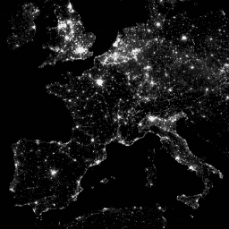
El sistema de exploración lineal (OLS) operativo del Programa Meteorológico de Defensa (DMSP) tiene la capacidad única de detectar fuentes de emisión visibles y de infrarrojo cercano (VNIR) durante la noche.
Esta colección contiene imágenes globales de luces nocturnas sin saturación del sensor. Por lo general, el sensor funciona con un ajuste de ganancia alta para permitir la detección de nubes iluminadas por la luz de la luna. Sin embargo, con la cuantificación de seis bits y el rango dinámico limitado, los datos registrados se saturan en los núcleos brillantes de los centros urbanos. Se obtuvo un conjunto limitado de observaciones con baja iluminación lunar, en el que la ganancia del detector se estableció significativamente más baja que su configuración operativa típica (a veces, en un factor de 100). Los datos dispersos adquiridos con ajustes de ganancia bajos se combinaron con los datos operativos adquiridos con ajustes de ganancia altos para producir el conjunto de imágenes globales de luces nocturnas sin saturación del sensor. Los datos de diferentes satélites se combinaron y fusionaron en el producto final para obtener la máxima cobertura. Para obtener más información, consulta este archivo README del proveedor.
Procesamiento de imágenes y datos del Centro Nacional de Datos Geofísicos de la NOAA Datos del DMSP recopilados por la Agencia Meteorológica de la Fuerza Aérea de EE.UU.
Bandas
Tamaño de píxel
927.67 metros
Bandas
| Nombre | Mín. | Máx. | Tamaño de los píxeles | Descripción |
|---|---|---|---|---|
avg_vis |
0* | 6060.6* | metros | Son los números de banda digitales promedio de las observaciones con detección de luz sin nubes. |
cf_cvg |
0* | 175* | metros | Coberturas sin nubes, la cantidad total de observaciones que se incluyeron en cada celda de cuadrícula de 30 segundos de arco. Esta imagen se puede usar para identificar áreas con una cantidad baja de observaciones en las que se reduce la calidad. |
Condiciones de Uso
Condiciones de Uso
Los datos, la información y los productos de la NOAA, independientemente del método de entrega, no están sujetos a derechos de autor y no tienen restricciones sobre su uso posterior por parte del público. Una vez que se obtienen, se pueden usar para cualquier fin legal. Los datos anteriores son de dominio público y se proporcionan sin restricciones de uso ni distribución.
Explora con Earth Engine
Editor de código (JavaScript)
var dataset = ee.ImageCollection('NOAA/DMSP-OLS/CALIBRATED_LIGHTS_V4')
                  .filter(ee.Filter.date('2010-01-01', '2010-12-31'));
var nighttimeLights = dataset.select('avg_vis');
var nighttimeLightsVis = {
  min: 3.0,
  max: 60.0,
};
Map.setCenter(7.82, 49.1, 4);
Map.addLayer(nighttimeLights, nighttimeLightsVis, 'Nighttime Lights');