- ডেটাসেটের প্রাপ্যতা
- 1979-01-01T00:00:00Z–2026-03-01T00:00:00Z
- ডেটাসেট প্রযোজক
- NOAA
- ক্যাডেন্স
- ৬ ঘন্টা
- ট্যাগ
বর্ণনা
This collection is no longer being updated. The Model is no longer being updated at the source.
NCEP-DOE Reanalysis 2 project is using a state-of-the-art analysis/forecast system to perform data assimilation using past data from 1979 through the previous year.
ব্যান্ড
ব্যান্ড
পিক্সেল সাইজ: ২৭৮৩০০ মিটার (সকল ব্যান্ড)
| নাম | ইউনিট | মিনিট | ম্যাক্স | পিক্সেল আকার | বর্ণনা |
|---|---|---|---|---|---|
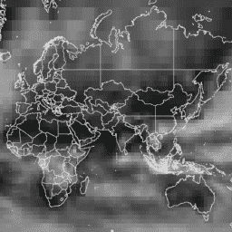
tcdc | % | ০* | ১০০* | ২৭৮৩০০ মিটার | মোট মেঘের আচ্ছাদন |
ব্যবহারের শর্তাবলী
ব্যবহারের শর্তাবলী
There are no restrictions on the use of these datasets.
উদ্ধৃতি
আর্থ ইঞ্জিন দিয়ে অন্বেষণ করুন
কোড এডিটর (জাভাস্ক্রিপ্ট)
// Import the dataset, filter the first five months of 2020.
var dataset = ee.ImageCollection('NOAA/NCEP_DOE_RE2/total_cloud_coverage')
                  .filter(ee.Filter.date('2020-01-01', '2020-06-01'));

// Select the total cloud cover band.
var totalCloudCoverage = dataset.select('tcdc');

// Reduce the image collection to per-pixel mean.
var totalCloudCoverageMean = totalCloudCoverage.mean();

// Define visualization parameters.
var vis = {
  min: 0,
  max: 80,  // dataset max is 100
  palette: ['black', 'white'],
};

// Display the dataset.
Map.setCenter(0, 20, 2);
Map.addLayer(totalCloudCoverageMean, vis, 'Total Cloud Coverage Data', false);

// Display a visualization image with opacity defined by cloud cover.
var visImg = totalCloudCoverageMean.visualize(vis)
  .updateMask(totalCloudCoverageMean.divide(100));
Map.addLayer(visImg, null, 'Total Cloud Coverage Vis.', true);