দৈনিক সুওমি ন্যাশনাল পোলার-অরবিটিং পার্টনারশিপ (Suomi NPP) NASA Visible Infrared Imaging Radiometer Suite (VIIRS) বার্নড এরিয়া (VNP64A1) সংস্করণ 1 ডেটা প্রোডাক্ট হল একটি মাসিক, গ্লোবাল গ্রিডেড 500m প্রোডাক্ট যাতে প্রতি-পিক্সেল পোড়া এলাকা এবং গুণমানের তথ্য রয়েছে। VNP64 বার্ন এলাকা ম্যাপিং পদ্ধতিতে 750m VIIRS চিত্রের সাথে 750m VIIRS সক্রিয় অগ্নি পর্যবেক্ষণের কাজ করা হয়েছে।
VIIRS ব্যান্ডগুলি যেগুলি বায়োমাস পোড়ানোর জন্য সংবেদনশীল এবং সংবেদনশীল উভয়ই আগুনের কারণে সৃষ্ট পরিবর্তনগুলি সনাক্ত করতে এবং অন্যান্য ধরণের পরিবর্তন থেকে তাদের আলাদা করতে ব্যবহৃত হয়।
প্রতিটি 500-মি গ্রিড সেলের জন্য বার্নের সাধারণ দিন (1-366)।
Burn_Date_Uncertainty
%
মিটার
পোড়ানোর তারিখে আনুমানিক অনিশ্চয়তা, দিনে। অবার্ন, আনম্যাপড, এবং ওয়াটার গ্রিড কোষগুলি মুখোশযুক্ত।
QA
মিটার
গুণমান নিশ্চিতকরণ সূচক
QA-এর জন্য বিটমাস্ক
বিট 0: ভূমি/জল অবস্থা
0: ওয়াটার গ্রিড সেল
1: ল্যান্ড গ্রিড সেল
বিট 1: বৈধ ডেটা পতাকা (0 = মিথ্যা, 1 = সত্য)। 1 এর মান নির্দেশ করে যে গ্রিড সেল প্রক্রিয়া করার জন্য প্রতিফলন সময় সিরিজে পর্যাপ্ত বৈধ ডেটা ছিল।
0: মিথ্যা
1: সত্য
বিট 2: সংক্ষিপ্ত ম্যাপিং সময়কাল (0 = মিথ্যা, 1 = সত্য)। এই পতাকাটি ইঙ্গিত করে যে নির্ভরযোগ্য ম্যাপিংয়ের সময় পুরো এক মাসের পণ্য সময়কালকে অন্তর্ভুক্ত করে না।
0: মিথ্যা
1: সত্য
বিট 3: অ্যালগরিদমের প্রাসঙ্গিক রিলেবেলিং পর্বের সময় গ্রিড সেল পুনরায় লেবেল করা হয়েছিল (0 = মিথ্যা, 1 = সত্য)।
0: মিথ্যা
1: সত্য
বিট 4: অতিরিক্ত বিট 0 এ সেট করা হয়েছে
0: অতিরিক্ত বিট
বিট 5-7: বিশেষ শর্ত কোড অবার্ন গ্রিড কোষের জন্য সংরক্ষিত। এই কোডটি বিশেষ পরিস্থিতির কারণে সনাক্তকরণ অ্যালগরিদম দ্বারা অবার্ন হিসাবে শ্রেণীবদ্ধ করা যেকোন গ্রিড কোষগুলির জন্য একটি ব্যাখ্যা প্রদান করে।
0: পোড়া, আনম্যাপ করা বা ওয়াটার গ্রিড সেল
1: বৈধ পর্যবেক্ষণগুলি সময়ের মধ্যে খুব কম ব্যবধানে
2: খুব কম প্রশিক্ষণ পর্যবেক্ষণ বা পোড়া এবং অবার্ন ক্লাসের মধ্যে অপর্যাপ্ত বর্ণালী বিভাজনযোগ্যতা।
3: সময় সিরিজের সীমাতে স্পষ্ট বার্ন তারিখ
4: স্পষ্ট জল দূষণ
5: ক্রমাগত হট স্পট
6: ভবিষ্যতে ব্যবহারের জন্য সংরক্ষিত
7: ভবিষ্যতে ব্যবহারের জন্য সংরক্ষিত
First_Day
মিটার
নির্ভরযোগ্য পরিবর্তন সনাক্তকরণের বছরের প্রথম দিন
Last_Day
মিটার
নির্ভরযোগ্য পরিবর্তন সনাক্তকরণের বছরের শেষ দিন
ব্যবহারের শর্তাবলী
ব্যবহারের শর্তাবলী
LP DAAC NASA ডেটা অবাধে অ্যাক্সেসযোগ্য; যাইহোক, যখন একজন লেখক এই তথ্যগুলি প্রকাশ করেন বা ডেটার উপর ভিত্তি করে কাজ করেন, তখন লেখককে অনুরোধ করা হয় যে প্রকাশনার পাঠ্যের মধ্যে ডেটাসেটগুলি উদ্ধৃত করুন এবং রেফারেন্স তালিকায় তাদের একটি রেফারেন্স অন্তর্ভুক্ত করুন।
দৈনিক সুওমি ন্যাশনাল পোলার-অরবিটিং পার্টনারশিপ (Suomi NPP) NASA Visible Infrared Imaging Radiometer Suite (VIIRS) বার্নড এরিয়া (VNP64A1) সংস্করণ 1 ডেটা প্রোডাক্ট হল একটি মাসিক, গ্লোবাল গ্রিডেড 500m প্রোডাক্ট যাতে প্রতি-পিক্সেল পোড়া এলাকা এবং গুণমানের তথ্য রয়েছে। VNP64 বার্ন এলাকা ম্যাপিং পদ্ধতিতে 750m VIIRS চিত্রের সাথে 750m VIIRS ব্যবহার করা হয়েছে …
[null,null,[],[[["\u003cp\u003eThe VNP64A1 dataset provides monthly, global, 500m resolution data on burned areas from 2014 to 2019.\u003c/p\u003e\n"],["\u003cp\u003eIt utilizes VIIRS imagery and active fire observations to detect and differentiate fire-induced changes from other land cover changes.\u003c/p\u003e\n"],["\u003cp\u003eThe dataset includes information on burn date, uncertainty, quality assurance, and the period of reliable change detection.\u003c/p\u003e\n"],["\u003cp\u003eUsers can access the data through NASA's Land Processes Distributed Active Archive Center (LP DAAC) and Google Earth Engine.\u003c/p\u003e\n"],["\u003cp\u003eProper citation is requested when publishing research based on this dataset, with links to relevant resources provided within the documentation.\u003c/p\u003e\n"]]],["The VNP64A1 dataset, provided by NASA LP DAAC, offers monthly global 500m gridded data on burned areas from 2014 to 2019. It uses VIIRS imagery and active fire observations to map burned areas and their quality, distinguishing fire-related changes from others. Data, available via Earth Engine, includes burn date, uncertainty, quality indicators, and detection period limits. The dataset's usage requires citing in any publication.\n"],null,["# VNP64A1: Burned Area Monthly L4 Global 500m SIN Grid\n\nDataset Availability\n: 2014-01-01T00:00:00Z--2019-01-01T00:00:00Z\n\nDataset Provider\n:\n\n\n [NASA LP DAAC at the USGS EROS Center](https://doi.org/10.5067/VIIRS/VNP64A1.001)\n\nCadence\n: 30 Days\n\nTags\n:\n[burn](/earth-engine/datasets/tags/burn) [change-detection](/earth-engine/datasets/tags/change-detection) [fire](/earth-engine/datasets/tags/fire) [land](/earth-engine/datasets/tags/land) [nasa](/earth-engine/datasets/tags/nasa) [noaa](/earth-engine/datasets/tags/noaa) [surface](/earth-engine/datasets/tags/surface) [viirs](/earth-engine/datasets/tags/viirs) \n\n#### Description\n\nThe daily Suomi National Polar-Orbiting Partnership (Suomi NPP) NASA Visible\nInfrared Imaging Radiometer Suite (VIIRS) Burned Area (VNP64A1) Version 1\ndata product is a monthly, global gridded 500m product containing per-pixel\nburned area and quality information. The VNP64 burned area mapping approach\nemploys 750m VIIRS imagery coupled with 750m VIIRS active fire\nobservations.\n\nVIIRS bands that are both sensitive and insensitive to biomass burning are\nused to detect changes caused by fire and to differentiate them from other\ntypes of change.\n\nDocumentation:\n\n- [User's Guide](https://lpdaac.usgs.gov/documents/1330/VNP64A1_User_Guide_V1.pdf)\n\n- [Algorithm Theoretical Basis Document (ATBD)](https://lpdaac.usgs.gov/documents/572/VNP64A1_ATBD_V1.pdf)\n\n- [General Documentation](https://lpdaac.usgs.gov/products/vnp64a1v001/)\n\n- [Land Product Quality Assessment website](https://landweb.modaps.eosdis.nasa.gov/browse?sensor=VIIRS&sat=SNPP)\n\n### Bands\n\n\n**Pixel Size**\n\n500 meters\n\n**Bands**\n\n| Name | Units | Pixel Size | Description |\n|-------------------------|-------|------------|----------------------------------------------------------------------------------------------------------|---|---|---|---|---|---|---|---|---|---|---|---|---|---|---|---|---|---|---|---|---|---|---|---|---|---|---|---|---|---|---|---|---|---|---|---|---|---|---|---|---|---|---|---|---|---|---|---|---|---|---|---|---|---|---|---|---|---|---|---|---|---|---|---|---|---|---|---|---|---|---|---|---|---|---|---|---|---|---|---|---|---|---|---|---|---|---|---|---|---|---|---|---|---|---|---|\n| `Burn_Date` | | meters | Ordinal day of burn (1-366) for each 500-m grid cell. |\n| `Burn_Date_Uncertainty` | % | meters | Estimated uncertainty in date of burn, in days. Unburned, unmapped, and water grid cells are masked out. |\n| `QA` | | meters | Quality Assurance Indicators |\n| Bitmask for QA - Bit 0: land/water state - 0: water grid cell - 1: land grid cell - Bit 1: Valid data flag (0 = false, 1 = true). A value of 1 indicates that there was sufficient valid data in the reflectance time series for the grid cell to be processed. - 0: false - 1: true - Bit 2: Shortened mapping period (0 = false, 1 = true). This flag indicates that the period of reliable mapping does not encompass the full one-month product period. - 0: false - 1: true - Bit 3: Grid cell was relabeled during the contextual relabeling phase of the algorithm (0 = false, 1 = true). - 0: false - 1: true - Bit 4: Spare bit set to 0 - 0: Spare bit - Bits 5-7: Special condition code reserved for unburned grid cells. This code provides an explanation for any grid cells that were summarily classified as unburned by the detection algorithm due to special circumstances. - 0: burned, unmapped, or water grid cells - 1: Valid observations spaced too sparsely in time - 2: Too few training observations or insufficient spectral separability between burned and unburned classes. - 3: Apparent burn date at limits of time series - 4: Apparent water contamination - 5: Persistent hot spot - 6: Reserved for future use - 7: Reserved for future use ||||||||||||||||||||||||||||||||||||||||||||||||||||||||||||||||||||||||||||||||||||||||||||||||||||\n| `First_Day` | | meters | First day of the year of reliable change detection |\n| `Last_Day` | | meters | Last day of the year of reliable change detection |\n\n### Terms of Use\n\n**Terms of Use**\n\nLP DAAC NASA data are freely accessible; however, when an author\npublishes these data or works based on the data, it is requested that the\nauthor cite the datasets within the text of the publication and include a\nreference to them in the reference list.\n\n### Citations\n\nCitations:\n\n- Please visit [LP DAAC 'Citing Our Data' page](https://lpdaac.usgs.gov/citing_our_data)\n for information on citing LP DAAC datasets.\n\n### DOIs\n\n- \u003chttps://doi.org/10.5067/VIIRS/VNP64A1.001\u003e\n\n### Explore with Earth Engine\n\n| **Important:** Earth Engine is a platform for petabyte-scale scientific analysis and visualization of geospatial datasets, both for public benefit and for business and government users. Earth Engine is free to use for research, education, and nonprofit use. To get started, please [register for Earth Engine access.](https://console.cloud.google.com/earth-engine)\n\n### Code Editor (JavaScript)\n\n```javascript\n
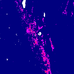
var image = ee.Image('NOAA/VIIRS/001/VNP64A1/2018_12_01');\nvar visualization = {\n bands: ['Last_Day'],\n min: 250.0,\n max: 320.0,\n palette: [\n '000080', '0000d9', '4000ff', '8000ff', '0080ff', '00ffff',\n '00ff80', '80ff00', 'daff00', 'ffff00', 'fff500', 'ffda00',\n 'ffb000', 'ffa400', 'ff4f00', 'ff2500', 'ff0a00', 'ff00ff',\n ]\n};\n\nMap.setCenter(-119.13, 38.32, 8);\nMap.addLayer(image, visualization, 'Last day');\n```\n[Open in Code Editor](https://code.earthengine.google.com/?scriptPath=Examples:Datasets/NOAA/NOAA_VIIRS_001_VNP64A1) \n[VNP64A1: Burned Area Monthly L4 Global 500m SIN Grid](/earth-engine/datasets/catalog/NOAA_VIIRS_001_VNP64A1) \nThe daily Suomi National Polar-Orbiting Partnership (Suomi NPP) NASA Visible Infrared Imaging Radiometer Suite (VIIRS) Burned Area (VNP64A1) Version 1 data product is a monthly, global gridded 500m product containing per-pixel burned area and quality information. The VNP64 burned area mapping approach employs 750m VIIRS imagery coupled with 750m VIIRS ... \nNOAA/VIIRS/001/VNP64A1, burn,change-detection,fire,land,nasa,noaa,surface,viirs \n2014-01-01T00:00:00Z/2019-01-01T00:00:00Z \n-90 -180 90 180 \nGoogle Earth Engine \nhttps://developers.google.com/earth-engine/datasets\n\n- [https://doi.org/10.5067/VIIRS/VNP64A1.001](https://doi.org/https://doi.org/10.5067/VIIRS/VNP64A1.001)\n- [https://doi.org/10.5067/VIIRS/VNP64A1.001](https://doi.org/https://developers.google.com/earth-engine/datasets/catalog/NOAA_VIIRS_001_VNP64A1)"]]