- Disponibilidade de conjuntos de dados
- 1999-06-30T00:00:00Z–2002-09-04T00:00:00Z
- Provedor de conjunto de dados
- NASA NSIDC DAAC no CIRES
- Tags
Descrição
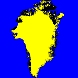
Esse conjunto de dados fornece máscaras completas de classificação de gelo terrestre e oceano a 15 m para a camada de gelo da Groenlândia. A cobertura de gelo foi mapeada usando uma combinação de imagens pancromáticas ortorretificadas (banda 8) do Landsat 7 Enhanced Thematic Mapper Plus (ETM+), distribuídas pelo USGS, e imagens de amplitude do radar de abertura sintética (SAR) do RADARSAT-1 produzidas e distribuídas pelo I. Joughin no Laboratório de Física Aplicada da Universidade de Washington.
As imagens do Landsat foram adquiridas nos meses de julho a setembro de 1999, 2000 e 2001 (principalmente 2000), e as imagens do RADARSAT foram adquiridas no outono de 2000.
Bandas
Tamanho do pixel
15 metros
Bandas
| Nome | Tamanho do pixel | Descrição |
|---|---|---|
ocean_mask |
metros | Máscara de oceano |
ice_mask |
metros | Máscara de gelo |
Tabela de classes ocean_mask
| Valor | Cor | Descrição |
|---|---|---|
| 0 | #000000 | todos os outros terrenos |
| 1 | #0000ff | oceano |
Tabela de classes ice_mask
| Valor | Cor | Descrição |
|---|---|---|
| 0 | #000000 | não é gelo de geleira |
| 1 | #ffffff | gelo de geleira |
Termos de Uso
Termos de Uso
Como condição para usar esses dados, você precisa citar o uso do conjunto de dados com a citação fornecida.
Citações
Howat, I.M., A. Negrete, B.E. Smith, 2014, The Greenland Ice Mapping Project (GIMP) land classification and surface elevation datasets, The Cryosphere, 8, 1509-1518, doi:10.5194/tc-8-1509-2014 artigo em PDF
DOIs
Explorar com o Earth Engine
Editor de código (JavaScript)
var dataset = ee.Image('OSU/GIMP/2000_ICE_OCEAN_MASK');
var oceanAndIceMaskVis = {
  min: 0.0,
  max: 1.0,
  bands: ['ice_mask', 'ice_mask', 'ocean_mask'],
};
Map.setCenter(-41.0, 74.0, 4);
Map.addLayer(dataset, oceanAndIceMaskVis, 'Ocean and Ice Mask');