- ডেটাসেটের প্রাপ্যতা
- 2000-01-01T00:00:00Z–2018-01-01T00:00:00Z
- ডেটাসেট প্রযোজক
- এনভাইরোমেট্রিক্স লিমিটেড
- ট্যাগ
বর্ণনা
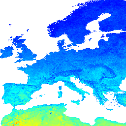
২০০০-২০১৭ সময় সিরিজের উপর ভিত্তি করে ১ কিমি উচ্চতায় MODIS LST-এর দিন ও রাতের দীর্ঘমেয়াদী পার্থক্য।
R-এর data.table প্যাকেজ এবং quantile ফাংশন ব্যবহার করে এটি নির্ণয় করা হয়েছে। MODIS LST প্রোডাক্ট সম্পর্কে আরও তথ্যের জন্য এই পৃষ্ঠাটি দেখুন। অ্যান্টার্কটিকা অন্তর্ভুক্ত নয়।
আর্থ ইঞ্জিনের বাইরে মানচিত্র দেখতে ও উপলব্ধি করতে এই পৃষ্ঠাটি ব্যবহার করুন।
যদি আপনি LandGIS মানচিত্রে কোনো ত্রুটি, অসঙ্গতি বা অসামঞ্জস্য খুঁজে পান অথবা আপনার কোনো প্রশ্ন থাকে, তাহলে অনুগ্রহ করে নিম্নলিখিত মাধ্যমগুলো ব্যবহার করুন:
ব্যান্ড
ব্যান্ড
পিক্সেল সাইজ: ১০০০ মিটার (সকল ব্যান্ড)
| নাম | ইউনিট | মিনিট | ম্যাক্স | স্কেল | পিক্সেল আকার | বর্ণনা |
|---|---|---|---|---|---|---|
jan | কে | -৪০.৫১৩৭* | ১৩৩৬.০৯* | ০.০২ | ১০০০ মিটার | দীর্ঘমেয়াদী ভূমি পৃষ্ঠের তাপমাত্রার মাসিক দিন-রাতের পার্থক্য |
feb | কে | -৪০.৫১৩৭* | ১৩৩৬.০৯* | ০.০২ | ১০০০ মিটার | দীর্ঘমেয়াদী ভূমি পৃষ্ঠের তাপমাত্রার মাসিক দিন-রাতের পার্থক্য |
mar | কে | -৪০.৫১৩৭* | ১৩৩৬.০৯* | ০.০২ | ১০০০ মিটার | দীর্ঘমেয়াদী ভূমি পৃষ্ঠের তাপমাত্রার মাসিক দিন-রাতের পার্থক্য |
apr | কে | -৪০.৫১৩৭* | ১৩৩৬.০৯* | ০.০২ | ১০০০ মিটার | দীর্ঘমেয়াদী ভূমি পৃষ্ঠের তাপমাত্রার মাসিক দিন-রাতের পার্থক্য |
may | কে | -৪০.৫১৩৭* | ১৩৩৬.০৯* | ০.০২ | ১০০০ মিটার | দীর্ঘমেয়াদী ভূমি পৃষ্ঠের তাপমাত্রার মাসিক দিন-রাতের পার্থক্য |
jun | কে | -৪০.৫১৩৭* | ১৩৩৬.০৯* | ০.০২ | ১০০০ মিটার | দীর্ঘমেয়াদী ভূমি পৃষ্ঠের তাপমাত্রার মাসিক দিন-রাতের পার্থক্য |
jul | কে | -৪০.৫১৩৭* | ১৩৩৬.০৯* | ০.০২ | ১০০০ মিটার | দীর্ঘমেয়াদী ভূমি পৃষ্ঠের তাপমাত্রার মাসিক দিন-রাতের পার্থক্য |
aug | কে | -৪০.৫১৩৭* | ১৩৩৬.০৯* | ০.০২ | ১০০০ মিটার | দীর্ঘমেয়াদী ভূমি পৃষ্ঠের তাপমাত্রার মাসিক দিন-রাতের পার্থক্য |
sep | কে | -৪০.৫১৩৭* | ১৩৩৬.০৯* | ০.০২ | ১০০০ মিটার | দীর্ঘমেয়াদী ভূমি পৃষ্ঠের তাপমাত্রার মাসিক দিন-রাতের পার্থক্য |
oct | কে | -৪০.৫১৩৭* | ১৩৩৬.০৯* | ০.০২ | ১০০০ মিটার | দীর্ঘমেয়াদী ভূমি পৃষ্ঠের তাপমাত্রার মাসিক দিন-রাতের পার্থক্য |
nov | কে | -৪০.৫১৩৭* | ১৩৩৬.০৯* | ০.০২ | ১০০০ মিটার | দীর্ঘমেয়াদী ভূমি পৃষ্ঠের তাপমাত্রার মাসিক দিন-রাতের পার্থক্য |
dec | কে | -৪০.৫১৩৭* | ১৩৩৬.০৯* | ০.০২ | ১০০০ মিটার | দীর্ঘমেয়াদী ভূমি পৃষ্ঠের তাপমাত্রার মাসিক দিন-রাতের পার্থক্য |
ব্যবহারের শর্তাবলী
ব্যবহারের শর্তাবলী
উদ্ধৃতি
২০০০-২০১৭ সময় সিরিজের উপর ভিত্তি করে দীর্ঘমেয়াদী MODIS LST দিনের ও রাতের তাপমাত্রা, স্ট্যান্ডার্ড ডেভিয়েশন (sd) এবং ১ কিমি উচ্চতায় পার্থক্য ১০.৫২৮১/জেনোডো.১৪২০১১৬
ডিওআই
আর্থ ইঞ্জিন দিয়ে অন্বেষণ করুন
কোড এডিটর (জাভাস্ক্রিপ্ট)
var dataset = ee.Image('OpenLandMap/CLM/CLM_LST_MOD11A2-DAYNIGHT_M/v01');

var visualization = {
  bands: ['jan'],
  min: -40.5137,
  max: 1336.09,
  palette: ['0000ff', '00ffff', 'ffff00', 'ff0000']
};

Map.centerObject(dataset);

Map.addLayer(dataset, visualization, 'Long-term Land Surface Temperature monthly day-night difference');