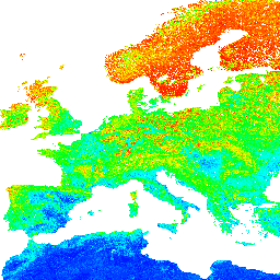
H2O তে মাটির pH 250 মিটার রেজোলিউশনে 6 আদর্শ গভীরতায় (0, 10, 30, 60, 100 এবং 200 সেমি)
প্রক্রিয়াকরণের ধাপগুলি এখানে বিস্তারিতভাবে বর্ণনা করা হয়েছে। অ্যান্টার্কটিকা অন্তর্ভুক্ত নয়।
আর্থ ইঞ্জিনের বাইরের মানচিত্রগুলি অ্যাক্সেস করতে এবং ভিজ্যুয়ালাইজ করতে, এই পৃষ্ঠাটি ব্যবহার করুন৷
আপনি যদি LandGIS মানচিত্রে একটি বাগ, আর্টিফ্যাক্ট বা অসঙ্গতি খুঁজে পান বা আপনার যদি কোনো প্রশ্ন থাকে তাহলে অনুগ্রহ করে নিম্নলিখিত চ্যানেলগুলি ব্যবহার করুন:
H2O-তে মাটির pH 250 মিটার রেজোলিউশনে 6 আদর্শ গভীরতায় (0, 10, 30, 60, 100 এবং 200 সেমি) প্রক্রিয়াকরণের ধাপগুলি এখানে বিশদভাবে বর্ণনা করা হয়েছে। অ্যান্টার্কটিকা অন্তর্ভুক্ত নয়। আর্থ ইঞ্জিনের বাইরের মানচিত্রগুলি অ্যাক্সেস করতে এবং ভিজ্যুয়ালাইজ করতে, এই পৃষ্ঠাটি ব্যবহার করুন৷ আপনি যদি একটি বাগ, আর্টিফ্যাক্ট বা…
[null,null,[],[[["\u003cp\u003eThis dataset provides soil pH measurements in H2O at six standard depths (0, 10, 30, 60, 100, and 200 cm).\u003c/p\u003e\n"],["\u003cp\u003eData is available globally at a 250-meter resolution, excluding Antarctica, from 1950 to 2018.\u003c/p\u003e\n"],["\u003cp\u003eThe dataset is provided by EnvirometriX Ltd and is licensed under CC-BY-SA-4.0.\u003c/p\u003e\n"],["\u003cp\u003eUsers can access and visualize the data using Google Earth Engine or the OpenLandMap platform.\u003c/p\u003e\n"],["\u003cp\u003eDetailed processing steps and support resources are available through provided links.\u003c/p\u003e\n"]]],[],null,["# OpenLandMap Soil pH in H2O\n\nDataset Availability\n: 1950-01-01T00:00:00Z--2018-01-01T00:00:00Z\n\nDataset Provider\n:\n\n\n [EnvirometriX Ltd](https://doi.org/10.5281/zenodo.1475459)\n\nTags\n:\n[envirometrix](/earth-engine/datasets/tags/envirometrix) [opengeohub](/earth-engine/datasets/tags/opengeohub) [openlandmap](/earth-engine/datasets/tags/openlandmap) [ph](/earth-engine/datasets/tags/ph) [soil](/earth-engine/datasets/tags/soil) \n\n#### Description\n\nSoil pH in H2O at 6 standard depths (0, 10, 30, 60, 100 and 200 cm) at 250 m resolution\n\nProcessing steps are described in detail [here](https://gitlab.com/openlandmap/global-layers/tree/master/soil).\nAntarctica is not included.\n\nTo access and visualize maps outside of Earth Engine, use [this page](https://opengeohub.org/about-openlandmap).\n\nIf you discover a bug, artifact or inconsistency in the LandGIS maps\nor if you have a question please use the following channels:\n\n- [Technical issues and questions about the code](https://gitlab.com/openlandmap/global-layers/issues)\n- [General questions and comments](https://disqus.com/home/forums/landgis/)\n\n### Bands\n\n\n**Pixel Size**\n\n250 meters\n\n**Bands**\n\n| Name | Min | Max | Scale | Pixel Size | Description |\n|--------|------|-------|-------|------------|--------------------------------|\n| `b0` | 42\\* | 110\\* | 10 | meters | Soil pH in H2O at 0 cm depth |\n| `b10` | 42\\* | 110\\* | 10 | meters | Soil pH in H2O at 10 cm depth |\n| `b30` | 42\\* | 110\\* | 10 | meters | Soil pH in H2O at 30 cm depth |\n| `b60` | 42\\* | 110\\* | 10 | meters | Soil pH in H2O at 60 cm depth |\n| `b100` | 42\\* | 110\\* | 10 | meters | Soil pH in H2O at 100 cm depth |\n| `b200` | 42\\* | 110\\* | 10 | meters | Soil pH in H2O at 200 cm depth |\n\n\\* estimated min or max value\n\n### Terms of Use\n\n**Terms of Use**\n\n[CC-BY-SA-4.0](https://spdx.org/licenses/CC-BY-SA-4.0.html)\n\n### Citations\n\nCitations:\n\n- Tomislav Hengl. (2018). Soil pH in H2O at 6 standard depths (0, 10, 30, 60, 100 and 200 cm) at 250 m resolution (Version v02) \\[Data set\\]. Zenodo.\n [10.5281/zenodo.1475459](https://doi.org/10.5281/zenodo.1475459)\n\n### DOIs\n\n- \u003chttps://doi.org/10.5281/zenodo.1475459\u003e\n\n### Explore with Earth Engine\n\n| **Important:** Earth Engine is a platform for petabyte-scale scientific analysis and visualization of geospatial datasets, both for public benefit and for business and government users. Earth Engine is free to use for research, education, and nonprofit use. To get started, please [register for Earth Engine access.](https://console.cloud.google.com/earth-engine)\n\n### Code Editor (JavaScript)\n\n```javascript\nvar dataset = ee.Image('OpenLandMap/SOL/SOL_PH-H2O_USDA-4C1A2A_M/v02');\n\nvar visualization = {\n bands: ['b0'],\n min: 42,\n max: 110,\n palette: [\n 'ff0000', 'ff1c00', 'ff3900', 'ff5500', 'ff7100', 'ff8e00',\n 'ffaa00', 'ffc600', 'ffe200', 'ffff00', 'e3ff00', 'c7ff00',\n 'aaff00', '8eff00', '72ff00', '55ff00', '39ff00', '1dff00',\n '01ff00', '00ff1c', '00ff38', '00ff54', '00ff71', '00ff8d',\n '00ffa9', '00ffc6', '00ffe2', '00fffe', '00e3ff', '00c7ff',\n '00abff', '008fff', '0072ff', '0056ff', '003aff', '001dff',\n '0001ff', '1b00ff', '3800ff', '5400ff',\n ]\n};\n\nMap.centerObject(dataset);\n\nMap.addLayer(dataset, visualization, 'Soil pH x 10 in H2O');\n```\n[Open in Code Editor](https://code.earthengine.google.com/?scriptPath=Examples:Datasets/OpenLandMap/OpenLandMap_SOL_SOL_PH-H2O_USDA-4C1A2A_M_v02) \n[OpenLandMap Soil pH in H2O](/earth-engine/datasets/catalog/OpenLandMap_SOL_SOL_PH-H2O_USDA-4C1A2A_M_v02) \nSoil pH in H2O at 6 standard depths (0, 10, 30, 60, 100 and 200 cm) at 250 m resolution Processing steps are described in detail here. Antarctica is not included. To access and visualize maps outside of Earth Engine, use this page. If you discover a bug, artifact or ... \nOpenLandMap/SOL/SOL_PH-H2O_USDA-4C1A2A_M/v02, envirometrix,opengeohub,openlandmap,ph,soil \n1950-01-01T00:00:00Z/2018-01-01T00:00:00Z \n-90 -180 90 180 \nGoogle Earth Engine \nhttps://developers.google.com/earth-engine/datasets\n\n- [https://doi.org/10.5281/zenodo.1475459](https://doi.org/https://doi.org/10.5281/zenodo.1475459)\n- [https://doi.org/10.5281/zenodo.1475459](https://doi.org/https://developers.google.com/earth-engine/datasets/catalog/OpenLandMap_SOL_SOL_PH-H2O_USDA-4C1A2A_M_v02)"]]