- 데이터 세트 제공
- 1950-01-01T00:00:00Z–2018-01-01T00:00:00Z
- 데이터 세트 출처
- EnvirometriX Ltd
- 태그
설명
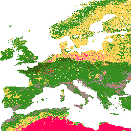
대역
대역
픽셀 크기: 250미터 (모든 밴드)
| 이름 | 픽셀 크기 | 설명 |
|---|---|---|
b0 |
250미터 | 0cm 깊이의 토양 질감 등급 (USDA 시스템) |
b10 |
250미터 | 10cm 깊이의 토양 질감 등급 (USDA 시스템) |
b30 |
250미터 | 30cm 깊이의 토양 질감 등급 (USDA 시스템) |
b60 |
250미터 | 60cm 깊이의 토양 질감 등급 (USDA 시스템) |
b100 |
250미터 | 100cm 깊이의 토양 질감 등급 (USDA 시스템) |
b200 |
250미터 | 200cm 깊이의 토양 질감 등급 (USDA 시스템) |
b0 클래스 표
| 값 | 색상 | 설명 |
|---|---|---|
| 1 | #d5c36b | Cl |
| 2 | #b96947 | SiCl |
| 3 | #9d3706 | SaCl |
| 4 | #ae868f | ClLo |
| 5 | #f86714 | SiClLo |
| 6 | #46d143 | SaClLo |
| 7 | #368f20 | Lo |
| 8 | #3e5a14 | SiLo |
| 9 | #ffd557 | SaLo |
| 10 | #fff72e | 시 |
| 11 | #ff5a9d | LoSa |
| 12 | #ff005b | 토 |
b10 클래스 표
| 값 | 색상 | 설명 |
|---|---|---|
| 1 | #d5c36b | Cl |
| 2 | #b96947 | SiCl |
| 3 | #9d3706 | SaCl |
| 4 | #ae868f | ClLo |
| 5 | #f86714 | SiClLo |
| 6 | #46d143 | SaClLo |
| 7 | #368f20 | Lo |
| 8 | #3e5a14 | SiLo |
| 9 | #ffd557 | SaLo |
| 10 | #fff72e | 시 |
| 11 | #ff5a9d | LoSa |
| 12 | #ff005b | 토 |
b30 클래스 표
| 값 | 색상 | 설명 |
|---|---|---|
| 1 | #d5c36b | Cl |
| 2 | #b96947 | SiCl |
| 3 | #9d3706 | SaCl |
| 4 | #ae868f | ClLo |
| 5 | #f86714 | SiClLo |
| 6 | #46d143 | SaClLo |
| 7 | #368f20 | Lo |
| 8 | #3e5a14 | SiLo |
| 9 | #ffd557 | SaLo |
| 10 | #fff72e | 시 |
| 11 | #ff5a9d | LoSa |
| 12 | #ff005b | 토 |
b60 클래스 표
| 값 | 색상 | 설명 |
|---|---|---|
| 1 | #d5c36b | Cl |
| 2 | #b96947 | SiCl |
| 3 | #9d3706 | SaCl |
| 4 | #ae868f | ClLo |
| 5 | #f86714 | SiClLo |
| 6 | #46d143 | SaClLo |
| 7 | #368f20 | Lo |
| 8 | #3e5a14 | SiLo |
| 9 | #ffd557 | SaLo |
| 10 | #fff72e | 시 |
| 11 | #ff5a9d | LoSa |
| 12 | #ff005b | 토 |
b100 클래스 표
| 값 | 색상 | 설명 |
|---|---|---|
| 1 | #d5c36b | Cl |
| 2 | #b96947 | SiCl |
| 3 | #9d3706 | SaCl |
| 4 | #ae868f | ClLo |
| 5 | #f86714 | SiClLo |
| 6 | #46d143 | SaClLo |
| 7 | #368f20 | Lo |
| 8 | #3e5a14 | SiLo |
| 9 | #ffd557 | SaLo |
| 10 | #fff72e | 시 |
| 11 | #ff5a9d | LoSa |
| 12 | #ff005b | 토 |
b200 클래스 표
| 값 | 색상 | 설명 |
|---|---|---|
| 1 | #d5c36b | Cl |
| 2 | #b96947 | SiCl |
| 3 | #9d3706 | SaCl |
| 4 | #ae868f | ClLo |
| 5 | #f86714 | SiClLo |
| 6 | #46d143 | SaClLo |
| 7 | #368f20 | Lo |
| 8 | #3e5a14 | SiLo |
| 9 | #ffd557 | SaLo |
| 10 | #fff72e | 시 |
| 11 | #ff5a9d | LoSa |
| 12 | #ff005b | 토 |
이용약관
이용약관
인용
인용:
Tomislav Hengl (2018). 250m에서 6개 토양 깊이 (0, 10, 30, 60, 100, 200cm)의 토양 질감 등급 (USDA 시스템)(버전 v02) [데이터 세트] Zenodo 10.5281/zenodo.1475451
DOI
Earth Engine으로 탐색
코드 편집기(JavaScript)
var dataset = ee.Image('OpenLandMap/SOL/SOL_TEXTURE-CLASS_USDA-TT_M/v02');

var visualization = {
  bands: ['b0'],
  min: 1.0,
  max: 12.0,
  palette: [
    'd5c36b','b96947','9d3706','ae868f','f86714','46d143',
    '368f20','3e5a14','ffd557','fff72e','ff5a9d','ff005b',
  ]
};

Map.centerObject(dataset);

Map.addLayer(dataset, visualization, 'Soil texture class (USDA system)');