OpenLandMap Soil Texture Class (USDA System)
Zadbaj o dobrą organizację dzięki kolekcji
Zapisuj i kategoryzuj treści zgodnie ze swoimi preferencjami.
Opis
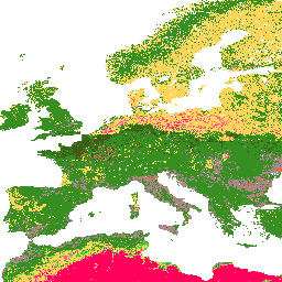
Klasy tekstury gleby (system USDA) dla 6 głębokości gleby (0, 10, 30, 60, 100 i 200 cm) w rozdzielczości 250 m.
Wartości pochodzą z przewidywanych frakcji tekstury gleby przy użyciu pakietu soiltexture w R.
Szczegółowe instrukcje znajdziesz tutaj .
Antarktyda nie jest uwzględniona.
Aby uzyskać dostęp do map i wyświetlać je poza Earth Engine, skorzystaj z tej strony .
Jeśli zauważysz błąd, artefakt lub niespójność na mapach LandGIS lub masz pytanie, skorzystaj z tych kanałów:
Pasma
Rozmiar piksela
250 metrów
Pasma
Nazwa
Rozmiar piksela
Opis
b0
metry
Klasa tekstury gleby (system USDA) na głębokości 0 cm
b10
metry
Klasa tekstury gleby (system USDA) na głębokości 10 cm
b30
metry
Klasa tekstury gleby (system USDA) na głębokości 30 cm
b60
metry
Klasa tekstury gleby (system USDA) na głębokości 60 cm
b100
metry
Klasa tekstury gleby (system USDA) na głębokości 100 cm
b200
metry
Klasa tekstury gleby (system USDA) na głębokości 200 cm
b0 Class Table
Wartość
Kolor
Opis
1
#d5c36b
Cl
2
#b96947
SiCl
3
#9d3706
SaCl
4
#ae868f
ClLo
5
#f86714
SiClLo
6
#46d143
SaClLo
7
#368f20
Lo
8
#3e5a14
SiLo
9
#ffd557
SaLo
10
#fff72e
Si
11
#ff5a9d
LoSa
12
#ff005b
So
b10 Class Table
Wartość
Kolor
Opis
1
#d5c36b
Cl
2
#b96947
SiCl
3
#9d3706
SaCl
4
#ae868f
ClLo
5
#f86714
SiClLo
6
#46d143
SaClLo
7
#368f20
Lo
8
#3e5a14
SiLo
9
#ffd557
SaLo
10
#fff72e
Si
11
#ff5a9d
LoSa
12
#ff005b
So
b30 Class Table
Wartość
Kolor
Opis
1
#d5c36b
Cl
2
#b96947
SiCl
3
#9d3706
SaCl
4
#ae868f
ClLo
5
#f86714
SiClLo
6
#46d143
SaClLo
7
#368f20
Lo
8
#3e5a14
SiLo
9
#ffd557
SaLo
10
#fff72e
Si
11
#ff5a9d
LoSa
12
#ff005b
So
b60 Class Table
Wartość
Kolor
Opis
1
#d5c36b
Cl
2
#b96947
SiCl
3
#9d3706
SaCl
4
#ae868f
ClLo
5
#f86714
SiClLo
6
#46d143
SaClLo
7
#368f20
Lo
8
#3e5a14
SiLo
9
#ffd557
SaLo
10
#fff72e
Si
11
#ff5a9d
LoSa
12
#ff005b
So
b100 Class Table
Wartość
Kolor
Opis
1
#d5c36b
Cl
2
#b96947
SiCl
3
#9d3706
SaCl
4
#ae868f
ClLo
5
#f86714
SiClLo
6
#46d143
SaClLo
7
#368f20
Lo
8
#3e5a14
SiLo
9
#ffd557
SaLo
10
#fff72e
Si
11
#ff5a9d
LoSa
12
#ff005b
So
Tabela klas b200
Wartość
Kolor
Opis
1
#d5c36b
Cl
2
#b96947
SiCl
3
#9d3706
SaCl
4
#ae868f
ClLo
5
#f86714
SiClLo
6
#46d143
SaClLo
7
#368f20
Lo
8
#3e5a14
SiLo
9
#ffd557
SaLo
10
#fff72e
Si
11
#ff5a9d
LoSa
12
#ff005b
So
Warunki korzystania z usługi
CC-BY-SA-4.0
Cytaty
Tomislav Hengl. (2018). Soil texture classes (USDA system) for 6 soil depths (0, 10, 30, 60, 100 and 200 cm) at 250 m (Version v02) [Zbiór danych]. Zenodo.
10.5281/zenodo.1475451
Odkrywanie za pomocą Earth Engine
Ważne:
Earth Engine to platforma do analizy naukowej i wizualizacji zbiorów danych geoprzestrzennych o rozmiarze petabajtów, która jest przeznaczona zarówno dla użytkowników publicznych, jak i biznesowych oraz rządowych.
Earth Engine jest bezpłatne do użytku w celach badawczych, edukacyjnych i non-profit. Aby rozpocząć, zarejestruj się, aby uzyskać dostęp do Earth Engine .
Edytor kodu (JavaScript)
var dataset = ee . Image ( 'OpenLandMap/SOL/SOL_TEXTURE-CLASS_USDA-TT_M/v02' );
var visualization = {
bands : [ 'b0' ],
min : 1.0 ,
max : 12.0 ,
palette : [
'd5c36b' , 'b96947' , '9d3706' , 'ae868f' , 'f86714' , '46d143' ,
'368f20' , '3e5a14' , 'ffd557' , 'fff72e' , 'ff5a9d' , 'ff005b' ,
]
};
Map . centerObject ( dataset );
Map . addLayer ( dataset , visualization , 'Soil texture class (USDA system)' );
Otwórz w edytorze kodu
[null,null,[],[[["\u003cp\u003eThis dataset provides soil texture classes based on the USDA system for 6 different soil depths (0, 10, 30, 60, 100, and 200 cm).\u003c/p\u003e\n"],["\u003cp\u003eData is available at a 250-meter resolution and covers the period from 1950 to 2018, excluding Antarctica.\u003c/p\u003e\n"],["\u003cp\u003eSoil texture classes are derived using the soiltexture package in R, with detailed processing steps documented on GitLab.\u003c/p\u003e\n"],["\u003cp\u003eThe dataset can be accessed and visualized within Google Earth Engine or through OpenGeoHub for use outside of Earth Engine.\u003c/p\u003e\n"],["\u003cp\u003eThis dataset is licensed under CC-BY-SA-4.0 and was provided by EnvirometriX Ltd.\u003c/p\u003e\n"]]],[],null,["# OpenLandMap Soil Texture Class (USDA System)\n\nDataset Availability\n: 1950-01-01T00:00:00Z--2018-01-01T00:00:00Z\n\nDataset Provider\n:\n\n\n [EnvirometriX Ltd](https://doi.org/10.5281/zenodo.1475451)\n\nTags\n:\n [envirometrix](/earth-engine/datasets/tags/envirometrix) [opengeohub](/earth-engine/datasets/tags/opengeohub) [openlandmap](/earth-engine/datasets/tags/openlandmap) [soil](/earth-engine/datasets/tags/soil) [usda](/earth-engine/datasets/tags/usda) \ntexture \n\n#### Description\n\nSoil texture classes (USDA system) for 6 soil depths (0, 10, 30, 60, 100 and 200 cm) at 250 m\n\nDerived from predicted soil texture fractions using the soiltexture package in R.\nProcessing steps are described in detail [here](https://gitlab.com/openlandmap/global-layers/tree/master/soil).\nAntarctica is not included.\n\nTo access and visualize maps outside of Earth Engine, use [this page](https://opengeohub.org/about-openlandmap).\n\nIf you discover a bug, artifact or inconsistency in the LandGIS maps\nor if you have a question please use the following channels:\n\n- [Technical issues and questions about the code](https://gitlab.com/openlandmap/global-layers/issues)\n- [General questions and comments](https://disqus.com/home/forums/landgis/)\n\n### Bands\n\n\n**Pixel Size**\n\n250 meters\n\n**Bands**\n\n| Name | Pixel Size | Description |\n|--------|------------|--------------------------------------------------|\n| `b0` | meters | Soil texture class (USDA system) at 0 cm depth |\n| `b10` | meters | Soil texture class (USDA system) at 10 cm depth |\n| `b30` | meters | Soil texture class (USDA system) at 30 cm depth |\n| `b60` | meters | Soil texture class (USDA system) at 60 cm depth |\n| `b100` | meters | Soil texture class (USDA system) at 100 cm depth |\n| `b200` | meters | Soil texture class (USDA system) at 200 cm depth |\n\n**b0 Class Table**\n\n| Value | Color | Description |\n|-------|---------|-------------|\n| 1 | #d5c36b | Cl |\n| 2 | #b96947 | SiCl |\n| 3 | #9d3706 | SaCl |\n| 4 | #ae868f | ClLo |\n| 5 | #f86714 | SiClLo |\n| 6 | #46d143 | SaClLo |\n| 7 | #368f20 | Lo |\n| 8 | #3e5a14 | SiLo |\n| 9 | #ffd557 | SaLo |\n| 10 | #fff72e | Si |\n| 11 | #ff5a9d | LoSa |\n| 12 | #ff005b | Sa |\n\n**b10 Class Table**\n\n| Value | Color | Description |\n|-------|---------|-------------|\n| 1 | #d5c36b | Cl |\n| 2 | #b96947 | SiCl |\n| 3 | #9d3706 | SaCl |\n| 4 | #ae868f | ClLo |\n| 5 | #f86714 | SiClLo |\n| 6 | #46d143 | SaClLo |\n| 7 | #368f20 | Lo |\n| 8 | #3e5a14 | SiLo |\n| 9 | #ffd557 | SaLo |\n| 10 | #fff72e | Si |\n| 11 | #ff5a9d | LoSa |\n| 12 | #ff005b | Sa |\n\n**b30 Class Table**\n\n| Value | Color | Description |\n|-------|---------|-------------|\n| 1 | #d5c36b | Cl |\n| 2 | #b96947 | SiCl |\n| 3 | #9d3706 | SaCl |\n| 4 | #ae868f | ClLo |\n| 5 | #f86714 | SiClLo |\n| 6 | #46d143 | SaClLo |\n| 7 | #368f20 | Lo |\n| 8 | #3e5a14 | SiLo |\n| 9 | #ffd557 | SaLo |\n| 10 | #fff72e | Si |\n| 11 | #ff5a9d | LoSa |\n| 12 | #ff005b | Sa |\n\n**b60 Class Table**\n\n| Value | Color | Description |\n|-------|---------|-------------|\n| 1 | #d5c36b | Cl |\n| 2 | #b96947 | SiCl |\n| 3 | #9d3706 | SaCl |\n| 4 | #ae868f | ClLo |\n| 5 | #f86714 | SiClLo |\n| 6 | #46d143 | SaClLo |\n| 7 | #368f20 | Lo |\n| 8 | #3e5a14 | SiLo |\n| 9 | #ffd557 | SaLo |\n| 10 | #fff72e | Si |\n| 11 | #ff5a9d | LoSa |\n| 12 | #ff005b | Sa |\n\n**b100 Class Table**\n\n| Value | Color | Description |\n|-------|---------|-------------|\n| 1 | #d5c36b | Cl |\n| 2 | #b96947 | SiCl |\n| 3 | #9d3706 | SaCl |\n| 4 | #ae868f | ClLo |\n| 5 | #f86714 | SiClLo |\n| 6 | #46d143 | SaClLo |\n| 7 | #368f20 | Lo |\n| 8 | #3e5a14 | SiLo |\n| 9 | #ffd557 | SaLo |\n| 10 | #fff72e | Si |\n| 11 | #ff5a9d | LoSa |\n| 12 | #ff005b | Sa |\n\n**b200 Class Table**\n\n| Value | Color | Description |\n|-------|---------|-------------|\n| 1 | #d5c36b | Cl |\n| 2 | #b96947 | SiCl |\n| 3 | #9d3706 | SaCl |\n| 4 | #ae868f | ClLo |\n| 5 | #f86714 | SiClLo |\n| 6 | #46d143 | SaClLo |\n| 7 | #368f20 | Lo |\n| 8 | #3e5a14 | SiLo |\n| 9 | #ffd557 | SaLo |\n| 10 | #fff72e | Si |\n| 11 | #ff5a9d | LoSa |\n| 12 | #ff005b | Sa |\n\n### Terms of Use\n\n**Terms of Use**\n\n[CC-BY-SA-4.0](https://spdx.org/licenses/CC-BY-SA-4.0.html)\n\n### Citations\n\nCitations:\n\n- Tomislav Hengl. (2018). Soil texture classes (USDA system) for 6 soil depths (0, 10, 30, 60, 100 and 200 cm) at 250 m (Version v02) \\[Data set\\]. Zenodo.\n [10.5281/zenodo.1475451](https://doi.org/10.5281/zenodo.1475451)\n\n### DOIs\n\n- \u003chttps://doi.org/10.5281/zenodo.1475451\u003e\n\n### Explore with Earth Engine\n\n| **Important:** Earth Engine is a platform for petabyte-scale scientific analysis and visualization of geospatial datasets, both for public benefit and for business and government users. Earth Engine is free to use for research, education, and nonprofit use. To get started, please [register for Earth Engine access.](https://console.cloud.google.com/earth-engine)\n\n### Code Editor (JavaScript)\n\n```javascript\nvar dataset = ee.Image('OpenLandMap/SOL/SOL_TEXTURE-CLASS_USDA-TT_M/v02');\n\nvar visualization = {\n bands: ['b0'],\n min: 1.0,\n max: 12.0,\n palette: [\n 'd5c36b','b96947','9d3706','ae868f','f86714','46d143',\n '368f20','3e5a14','ffd557','fff72e','ff5a9d','ff005b',\n ]\n};\n\nMap.centerObject(dataset);\n\nMap.addLayer(dataset, visualization, 'Soil texture class (USDA system)');\n```\n[Open in Code Editor](https://code.earthengine.google.com/?scriptPath=Examples:Datasets/OpenLandMap/OpenLandMap_SOL_SOL_TEXTURE-CLASS_USDA-TT_M_v02) \n[OpenLandMap Soil Texture Class (USDA System)](/earth-engine/datasets/catalog/OpenLandMap_SOL_SOL_TEXTURE-CLASS_USDA-TT_M_v02) \nSoil texture classes (USDA system) for 6 soil depths (0, 10, 30, 60, 100 and 200 cm) at 250 m Derived from predicted soil texture fractions using the soiltexture package in R. Processing steps are described in detail here. Antarctica is not included. To access and visualize maps outside of ... \nOpenLandMap/SOL/SOL_TEXTURE-CLASS_USDA-TT_M/v02, envirometrix,opengeohub,openlandmap,soil,usda \n1950-01-01T00:00:00Z/2018-01-01T00:00:00Z \n-90 -180 90 180 \nGoogle Earth Engine \nhttps://developers.google.com/earth-engine/datasets\n\n- [https://doi.org/10.5281/zenodo.1475451](https://doi.org/https://doi.org/10.5281/zenodo.1475451)\n- [https://doi.org/10.5281/zenodo.1475451](https://doi.org/https://developers.google.com/earth-engine/datasets/catalog/OpenLandMap_SOL_SOL_TEXTURE-CLASS_USDA-TT_M_v02)"]]