- 데이터 세트 사용 가능 기간
- 1950-01-01T00:00:00Z–2018-01-01T00:00:00Z
- 데이터 세트 제공업체
- EnvirometriX Ltd
- 태그
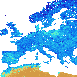
설명
250m 해상도에서 6개 표준 깊이 (0, 10, 30, 60, 100, 200cm)에서 예측된 33kPa 및 1500kPa 흡입의 토양 수분 함량 (부피 %)
학습 포인트는 전 세계 토양 프로필을 기반으로 합니다.
데이터 가져오기 단계는 여기에서 확인할 수 있습니다. 공간 예측 단계는 여기에 자세히 설명되어 있습니다. 참고: 이는 실제로 측정되고 매핑된 토양 함량 값입니다. 누락된 NCSS 벌크 밀도를 채우는 경우를 제외하고는 Pedo-Transfer-Functions가 사용되지 않았습니다. 레이어별 사용 가능한 물 용량(mm)(필드 용량과 시들음 지점에 레이어 두께를 곱한 값의 차이로 도출됨)은 여기에서 확인할 수 있습니다. 남극은 포함되지 않습니다.
Earth Engine 외부에서 지도에 액세스하고 시각화하려면 이 페이지를 사용하세요.
LandGIS 지도에서 버그, 아티팩트 또는 불일치를 발견하거나 질문이 있는 경우 다음 채널을 사용하세요.
대역
픽셀 크기
250미터
대역
| 이름 | 단위 | 최소 | 최대 | 픽셀 크기 | 설명 |
|---|---|---|---|---|---|
b0 |
% | 0* | 52.974* | 미터 | 0cm 깊이에서 33kPa (포장 용량)의 토양 수분 함량 |
b10 |
% | 0* | 52.974* | 미터 | 10cm 깊이에서 33kPa (포장 용수량)의 토양 수분 함량 |
b30 |
% | 0* | 52.974* | 미터 | 30cm 깊이에서 33kPa (포장 용량)의 토양 수분 함량 |
b60 |
% | 0* | 52.974* | 미터 | 60cm 깊이에서 33kPa (포장 용량)의 토양 수분 함량 |
b100 |
% | 0* | 52.974* | 미터 | 100cm 깊이에서 33kPa (포장 용량)의 토양 수분 함량 |
b200 |
% | 0* | 52.974* | 미터 | 200cm 깊이에서 33kPa (포장 용량)의 토양 수분 함량 |
이용약관
이용약관
인용
Tomislav Hengl, Surya Gupta. (2019). 250m 해상도에서 6개 표준 깊이 (0, 10, 30, 60, 100, 200cm)에서 예측된 33kPa 및 1500kPa 흡입의 토양 수분 함량 (부피 %)입니다 (버전 v01) [데이터 세트]. Zenodo 10.5281/zenodo.2629589
DOI
Earth Engine으로 탐색하기
코드 편집기(JavaScript)
var dataset = ee.Image('OpenLandMap/SOL/SOL_WATERCONTENT-33KPA_USDA-4B1C_M/v01');

var visualization = {
  bands: ['b0'],
  min: 0.0,
  max: 52.9740182135385,
  palette: [
    'd29642','eec764','b4ee87','32eeeb','0c78ee','2601b7',
    '083371',
  ]
};

Map.centerObject(dataset);

Map.addLayer(dataset, visualization, 'Soil water content at 33kPa (field capacity)');