- ডেটাসেট উপলব্ধতা
- 2017-01-01T00:00:00Z–2020-01-01T00:00:00Z
- ডেটাসেট প্রদানকারী
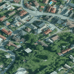
- স্লোভাকিয়া অর্থোফটোমোজাইক
- ট্যাগ
বর্ণনা
স্লোভাক প্রজাতন্ত্রের অর্থোফোটোমোসাইক হল কানেক্টিং লাইন বরাবর ওভারল্যাপ, ফাঁক এবং দৃশ্যমান উজ্জ্বলতা এবং রঙের পার্থক্য ছাড়াই রঙের অর্থোইমেজের একটি সেট।
আরও তথ্যের জন্য, অনুগ্রহ করে স্লোভাকিয়া অর্থোফটোস ডকুমেন্টেশন দেখুন
ব্যান্ড
পিক্সেল সাইজ
0.25 মিটার
ব্যান্ড
| নাম | ইউনিট | মিন | সর্বোচ্চ | পিক্সেল সাইজ | বর্ণনা |
|---|---|---|---|---|---|
R | dn | 0 | 255 | মিটার | লাল |
G | dn | 0 | 255 | মিটার | সবুজ |
B | dn | 0 | 255 | মিটার | নীল |
ব্যবহারের শর্তাবলী
ব্যবহারের শর্তাবলী
ব্যবহারকারী অন্যান্য ডেটার সাথে সোর্স ডেটা একত্রিত করার, বাণিজ্যিক এবং অ-বাণিজ্যিক উদ্দেশ্যে তার নিজের কাজ তৈরিতে এটি ব্যবহার করার, একটি নতুন কাজ তৈরি করার, ইন্টারনেটে কাজটি প্রকাশ করার, উত্স ডেটাকে একটি বেস ম্যাপ হিসাবে প্রকাশ করার, ওয়েব অ্যাপের মাধ্যমে অন্যান্য ডেটা/থিম্যাটিক স্তরগুলির সাথে সম্পর্কিত উত্স ডেটা প্রকাশ করার অধিকারী। ব্যবহারকারী তার নিজের কাজ তৈরি করার সময় এবং এটি প্রকাশ করার সময় উৎস ডেটার লেখকের নাম প্রদান করতে বাধ্য: "GKÚ Bratislava, NLC"।
আরো বিস্তারিত জানার জন্য, ব্যবহারের শর্তাবলী দেখুন
উদ্ধৃতি
জিকেইউ ব্রাতিস্লাভা, এনএলসি
আর্থ ইঞ্জিন দিয়ে অন্বেষণ করুন
কোড এডিটর (জাভাস্ক্রিপ্ট)
var dataset = ee.ImageCollection('Slovakia/orthos/25cm');

Map.setCenter(19.163, 48.751, 15);
Map.addLayer(dataset, {}, 'Slovakia orthophotos RGB');