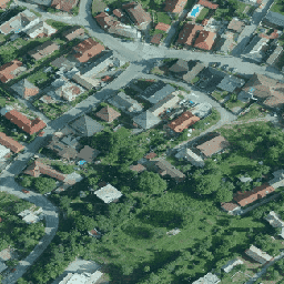
Ortofotomozaika Republiki Słowackiej to zestaw kolorowych ortoobrazów bez nakładania się, przerw i widocznych różnic jasności i koloru wzdłuż linii łączących.
Użytkownik ma prawo łączyć dane źródłowe z innymi danymi, wykorzystywać je do tworzenia własnych prac do celów komercyjnych i niekomercyjnych, tworzyć nowe prace, publikować je w internecie, publikować dane źródłowe jako mapę bazową, publikować dane źródłowe w połączeniu z innymi danymi lub warstwami tematycznymi za pomocą aplikacji internetowych. Użytkownik jest zobowiązany do podania nazwy autora danych źródłowych podczas tworzenia własnego dzieła i publikowania go w następujący sposób: „GKÚ Bratislava, NLC”.
Ortofotomozaika Słowacji to zestaw kolorowych ortoobrazów bez nakładania się, przerw i widocznych różnic w jasności i kolorze wzdłuż linii łączących. Więcej informacji znajdziesz w dokumentacji dotyczącej ortofotomap Słowacji
[null,null,[],[[["\u003cp\u003eThe Slovakia orthophotomosaic dataset provides high-resolution (25cm) RGB orthoimagery for the Slovak Republic from 2017 to 2020.\u003c/p\u003e\n"],["\u003cp\u003eThe dataset is seamless, meaning it's free of overlaps, gaps, and visible brightness or color differences.\u003c/p\u003e\n"],["\u003cp\u003eUsers can combine the data with other datasets, use it for commercial and non-commercial purposes, and publish it with attribution to "GKÚ Bratislava, NLC".\u003c/p\u003e\n"],["\u003cp\u003eThe dataset is accessible through Google Earth Engine and is free to use for research, education, and nonprofit purposes.\u003c/p\u003e\n"]]],[],null,["# Slovakia orthophotos\n\nDataset Availability\n: 2017-01-01T00:00:00Z--2020-01-01T00:00:00Z\n\nDataset Provider\n:\n\n\n [Slovakia orthophotomosaic](https://www.geoportal.sk/en/zbgis/orthophotomosaic/)\n\nTags\n:\n[orthophotos](/earth-engine/datasets/tags/orthophotos) [rgb](/earth-engine/datasets/tags/rgb) \n\n#### Description\n\nOrthophotomosaic of the Slovak Republic is a set of color orthoimages\nwithout overlaps, gaps and visible brightness and color differences along\nthe connecting lines.\n\nFor more information, please see the\n[Slovakia orthophotos documentation](https://www.geoportal.sk/files/zbgis/orto/technicka_sprava_ortofotomozaika_sr_2017-2019.pdf)\n\n### Bands\n\n\n**Pixel Size**\n\n0.25 meters\n\n**Bands**\n\n| Name | Units | Min | Max | Pixel Size | Description |\n|------|-------|-----|-----|------------|-------------|\n| `R` | dn | 0 | 255 | meters | Red |\n| `G` | dn | 0 | 255 | meters | Green |\n| `B` | dn | 0 | 255 | meters | Blue |\n\n### Terms of Use\n\n**Terms of Use**\n\nThe User is entitled to combine the Source Data with other data, use it in\nthe creation of his/her own work for commercial and non-commercial purposes,\ncreate a new work, publish the work on the Internet, publish the Source Data\nas a base map, publish the Source Data in connection with other\ndata/thematic layers through web apps. The User is obliged to provide the\nname of the Author of the Source Data when creating his/her own work and\nwhen publishing it as follows: \"GKÚ Bratislava, NLC\".\n\nFor more details, see [Terms of use](https://www.geoportal.sk/files/zbgis/orto/licencne_podmienky_orto.zip)\n\n### Citations\n\nCitations:\n\n- GKU Bratislava, NLC\n\n### Explore with Earth Engine\n\n| **Important:** Earth Engine is a platform for petabyte-scale scientific analysis and visualization of geospatial datasets, both for public benefit and for business and government users. Earth Engine is free to use for research, education, and nonprofit use. To get started, please [register for Earth Engine access.](https://console.cloud.google.com/earth-engine)\n\n### Code Editor (JavaScript)\n\n```javascript\nvar dataset = ee.ImageCollection('Slovakia/orthos/25cm');\n\nMap.setCenter(19.163, 48.751, 15);\nMap.addLayer(dataset, {}, 'Slovakia orthophotos RGB');\n```\n[Open in Code Editor](https://code.earthengine.google.com/?scriptPath=Examples:Datasets/Slovakia/Slovakia_orthos_25cm) \n[Slovakia orthophotos](/earth-engine/datasets/catalog/Slovakia_orthos_25cm) \nOrthophotomosaic of the Slovak Republic is a set of color orthoimages without overlaps, gaps and visible brightness and color differences along the connecting lines. For more information, please see the Slovakia orthophotos documentation \nSlovakia/orthos/25cm, orthophotos,rgb \n2017-01-01T00:00:00Z/2020-01-01T00:00:00Z \n47.44 16.5 49.36 22.33 \nGoogle Earth Engine \nhttps://developers.google.com/earth-engine/datasets\n\n- [](https://doi.org/https://www.geoportal.sk/en/zbgis/orthophotomosaic/)\n- [](https://doi.org/https://developers.google.com/earth-engine/datasets/catalog/Slovakia_orthos_25cm)"]]