- Доступность набора данных
- 2007-01-01T00:00:00Z–2019-01-01T00:00:00Z
- Поставщик наборов данных
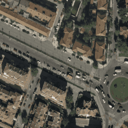
- Ортофото Испании
- Теги
- pnoa
Описание
Мозаики ортофотоснимков, полученных в ходе полётов, выполненных в период с 2007 по 2018 год различными государственными органами, с разрешением 10 см. Эти данные предоставлены Национальным планом аэроортофотосъёмки Испании ( PNOA ).
Более подробную информацию можно найти в документации по ортофотопланам Испании.
Группы
Размер пикселя
0,1 метра
Группы
| Имя | Единицы | Мин. | Макс | Размер пикселя | Описание |
|---|---|---|---|---|---|
R | дн | 0 | 255 | метров | Красный |
G | дн | 0 | 255 | метров | Зеленый |
B | дн | 0 | 255 | метров | Синий |
Условия эксплуатации
Условия эксплуатации
Данные предоставляются бесплатно и могут свободно использоваться в любых законных целях, единственным строгим обязательством является признание и упоминание происхождения и права собственности на географические информационные продукты и услуги, лицензированные как National Geographic Institute.
Более подробную информацию см. в Условиях использования.
Цитаты
Национальный географический институт Испании
Исследуйте с Earth Engine
Редактор кода (JavaScript)
var dataset = ee.ImageCollection('Spain/PNOA/PNOA10');
Map.setCenter(-1.859852, 38.983734, 19);
Map.addLayer(dataset, {}, 'Spain RGB (10cm)');