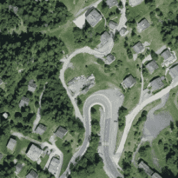
Mozaika ortofotomap SWISSIMAGE o rozdzielczości 10 cm to zbiór nowych kolorowych cyfrowych zdjęć lotniczych obejmujących całą Szwajcarię. Rozdzielczość w terenie wynosi 10 cm na równinach i w głównych dolinach alpejskich oraz 25 cm w Alpach. Jest ona aktualizowana co roku.
Ta kolekcja RGB zawiera cyfrowe zdjęcia lotnicze z 3 pasami.
Odchylenie standardowe precyzji pozycji: +/- 0,15 m przy odległości próbki od ziemi wynoszącej 0,1 m.
Pasma
Rozmiar piksela 0,1 m
Pasma
Nazwa
Minimum
Maks.
Rozmiar piksela
Długość fali
Opis
R
0
255
metry
619-651nm
Czerwony
G
0
255
metry
525–585 nm
Zielony
B
0
255
metry
435-495nm
Niebieski
Warunki korzystania z usługi
Bezpłatne dane geograficzne i usługi geograficzne swisstopo mogą być wykorzystywane, rozpowszechniane i udostępniane. Mogą one być ponadto wzbogacane i przetwarzane, a także wykorzystywane komercyjnie.
Mozaika ortofotomap SWISSIMAGE 10 cm to zbiór nowych kolorowych cyfrowych zdjęć lotniczych obejmujących całą Szwajcarię. Rozdzielczość przestrzenna wynosi 10 cm na równinach i w głównych dolinach alpejskich oraz 25 cm w Alpach. Jest on aktualizowany co roku. Więcej informacji znajdziesz w sekcji…
[null,null,[],[[["\u003cp\u003eSWISSIMAGE 10 cm orthophoto mosaic provides high-resolution aerial imagery of Switzerland, with 10 cm resolution in plains and valleys and 25 cm in the Alps.\u003c/p\u003e\n"],["\u003cp\u003eThe dataset is updated annually and covers the period from 2017 to 2021, offering RGB imagery with three bands (Red, Green, Blue).\u003c/p\u003e\n"],["\u003cp\u003eIt is freely available for use, distribution, and commercial purposes with proper attribution to swisstopo.\u003c/p\u003e\n"],["\u003cp\u003eUsers can explore and analyze this dataset using Google Earth Engine, a platform for petabyte-scale geospatial analysis.\u003c/p\u003e\n"],["\u003cp\u003eThe dataset's precision in position has a standard deviation of +/- 0.15 m for the 0.1 m ground sample distance.\u003c/p\u003e\n"]]],["The dataset, provided by Topography swisstopo, contains SWISSIMAGE 10 cm orthophoto mosaics of Switzerland from 2017 to 2021. The images are updated yearly, have a ground resolution of 10 cm (plains/valleys) and 25 cm (Alps). It consist of digital aerial images with red, green, and blue bands, and a pixel size of 0.1 meters. Users may use, distribute, and process the data freely with mandatory source reference. The dataset is accessible through Google Earth Engine.\n"],null,["# SWISSIMAGE 10 cm RGB imagery\n\nDataset Availability\n: 2017-01-01T00:00:00Z--2021-01-01T00:00:00Z\n\nDataset Provider\n:\n\n\n [Topography swisstopo](https://www.swisstopo.admin.ch/en/geodata/images/ortho/swissimage10.html)\n\nTags\n:\n [orthophotos](/earth-engine/datasets/tags/orthophotos) [rgb](/earth-engine/datasets/tags/rgb) \n swissimage \nswisstopo \n\n#### Description\n\nThe SWISSIMAGE 10 cm orthophoto mosaic is an assembly of new color digital\naerial images over the whole of Switzerland with a ground resolution of\n10 cm in the plains and the main alpine valleys and 25 cm in the Alps. It\nis updated annually.\n\nFor more information, please see the\n[SWISSIMAGE10cm_FR documentation](https://backend.swisstopo.admin.ch/fileservice/sdweb-docs-prod-swisstopoch-files/files/2023/11/14/a84642dc-5feb-48e5-af6b-55df4ae7a10b.pdf)\n\nThis RGB collection contains digital aerial images with three bands.\nStandard deviation for the precision in position: +/- 0.15 m for the ground\nsample distance of 0.1 m.\n\n### Bands\n\n\n**Pixel Size**\n\n0.1 meters\n\n**Bands**\n\n| Name | Min | Max | Pixel Size | Wavelength | Description |\n|------|-----|-----|------------|------------|-------------|\n| `R` | 0 | 255 | meters | 619-651nm | Red |\n| `G` | 0 | 255 | meters | 525-585nm | Green |\n| `B` | 0 | 255 | meters | 435-495nm | Blue |\n\n### Terms of Use\n\n**Terms of Use**\n\nThe free geodata and geoservices of swisstopo may be used, distributed and\nmade accessible. Furthermore, they may be enriched and processed and also\nused commercially.\n\nA reference to the source is mandatory.\nplease see the [Terms of use](https://www.swisstopo.admin.ch/en/terms-and-conditions)\n\n### Citations\n\nCitations:\n\n- Copyright Federal Office of Topography swisstopo\n\n### Explore with Earth Engine\n\n| **Important:** Earth Engine is a platform for petabyte-scale scientific analysis and visualization of geospatial datasets, both for public benefit and for business and government users. Earth Engine is free to use for research, education, and nonprofit use. To get started, please [register for Earth Engine access.](https://console.cloud.google.com/earth-engine)\n\n### Code Editor (JavaScript)\n\n```javascript\nvar dataset = ee.Image('Switzerland/SWISSIMAGE/orthos/10cm/2017');\n\nMap.setCenter(7.75, 46.02, 18);\nMap.addLayer(dataset, null, 'Switzerland RGB (10 cm)');\n```\n[Open in Code Editor](https://code.earthengine.google.com/?scriptPath=Examples:Datasets/Switzerland/Switzerland_SWISSIMAGE_orthos_10cm) \n[SWISSIMAGE 10 cm RGB imagery](/earth-engine/datasets/catalog/Switzerland_SWISSIMAGE_orthos_10cm) \nThe SWISSIMAGE 10 cm orthophoto mosaic is an assembly of new color digital aerial images over the whole of Switzerland with a ground resolution of 10 cm in the plains and the main alpine valleys and 25 cm in the Alps. It is updated annually. For more information, please see ... \nSwitzerland/SWISSIMAGE/orthos/10cm, orthophotos,rgb \n2017-01-01T00:00:00Z/2021-01-01T00:00:00Z \n45.8 5.9 47.8 10.6 \nGoogle Earth Engine \nhttps://developers.google.com/earth-engine/datasets\n\n- [](https://doi.org/https://www.swisstopo.admin.ch/en/geodata/images/ortho/swissimage10.html)\n- [](https://doi.org/https://developers.google.com/earth-engine/datasets/catalog/Switzerland_SWISSIMAGE_orthos_10cm)"]]