- Доступность набора данных
- 2017-01-01T00:00:00Z–2021-01-01T00:00:00Z
- Поставщик наборов данных
- Топография swisstopo
- Теги
- swissimage
Описание
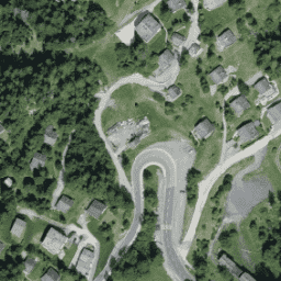
Ортофотомозаика SWISSIMAGE 10 см представляет собой набор новых цветных цифровых аэрофотоснимков всей территории Швейцарии с разрешением на местности 10 см на равнинах и основных альпийских долинах и 25 см в Альпах. Она обновляется ежегодно.
Более подробную информацию можно найти в документации SWISSIMAGE10cm_FR.
Эта коллекция RGB содержит цифровые аэрофотоснимки в трёх диапазонах. Среднеквадратичное отклонение точности определения местоположения: +/- 0,15 м при расстоянии от земной поверхности 0,1 м.
Группы
Размер пикселя
0,1 метра
Группы
| Имя | Мин. | Макс | Размер пикселя | Длина волны | Описание |
|---|---|---|---|---|---|
R | 0 | 255 | метров | 619-651 нм | Красный |
G | 0 | 255 | метров | 525-585 нм | Зеленый |
B | 0 | 255 | метров | 435-495 нм | Синий |
Условия эксплуатации
Условия эксплуатации
Бесплатные геоданные и геосервисы swisstopo могут использоваться, распространяться и предоставляться. Кроме того, их можно обогащать, обрабатывать и использовать в коммерческих целях.
Ссылка на источник обязательна. См. Условия использования.
Цитаты
Авторские права принадлежат Федеральному ведомству топографии swisstopo
Исследуйте с Earth Engine
Редактор кода (JavaScript)
var dataset = ee.Image('Switzerland/SWISSIMAGE/orthos/10cm/2017');

Map.setCenter(7.75, 46.02, 18);
Map.addLayer(dataset, null, 'Switzerland RGB (10 cm)');