Page Summary
-
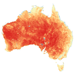
This dataset provides accurate actual evapotranspiration (AET or ETa) for Australia using the CMRSET algorithm from 2000-02-01 to 2025-08-01.
-
The dataset utilizes Landsat data primarily, with blending and interpolation used to fill gaps due to cloud cover or sensor issues.
-
Accurate AET information is critical for irrigation, food security, environmental management, and modeling catchment water balance in Australia.
-
The dataset includes an 'ETa' band for average daily evapotranspiration and a 'pixel_qa' band with quality assurance information.
- Dataset Availability
- 2000-02-01T00:00:00Z–2025-09-01T00:00:00Z
- Dataset Provider
- TERN Landscapes / CSIRO Land and Water
- Tags
Description
This dataset provides accurate actual evapotranspiration (AET or ETa) for Australia using the CMRSET algorithm. The AET band (named 'ETa') contains the average daily value from the CMRSET model for all cloud-free Landsat observations in that month (indicated with value 3 in the AET Data Source QA bits). After the Landsat 7 ETM+ Scan Line Corrector (SLC) failed on 31 May 2003, Landsat 7 ETM+ data are only used if there are no cloud-free Landsat 5 TM or Landsat 8 OLI data for that month. If there is no cloud-free Landsat data available, pixels are infilled with blended data. The blended data will be blended Landsat-MODIS until Feb 2012, then blended Landsat-VIIRS onwards (indicated with value 2 in the AET Data Source QA bits). If there is no blended data available in a month, then missing monthly AET values are linearly interpolated (indicated with value 1 in the AET Data Source QA bits). This means monthly 30 m AET data covering all Australia, with no gaps due to cloud, are available and ready to use.
Accurate AET information is important for irrigation, food security, and environmental management. Like many other parts of the world, water availability in Australia is limited and AET is the largest consumptive component of the water balance. In Australia 70% of available water is used for crop and pasture irrigation. Better monitoring will support improved water use efficiency in this sector, with any water savings available as environmental flows. Additionally, ground-water dependent ecosystems (GDE) occupy a small area yet are "biodiversity hotspots". Knowing their water needs enables enhanced management of these critical areas. AET can also be used to model the catchment water balance. If used in water balance (mass balance) calculations, then this AET value needs to be multiplied by the number of days in the month.
To let the developers know you are using this dataset, to get information on updates, or if you have any questions please contact: tim.mcvicar@csiro.au, tom.vanniel@csiro.au, jamie.vleeshouwer@csiro.au.
Bands
Pixel Size
30 meters
Bands
| Name | Units | Pixel Size | Description | ||||||||||||||||||||||||||||||||||||||||||||||||||||||||||||||||||||||||||||||||||||||||||||||||
|---|---|---|---|---|---|---|---|---|---|---|---|---|---|---|---|---|---|---|---|---|---|---|---|---|---|---|---|---|---|---|---|---|---|---|---|---|---|---|---|---|---|---|---|---|---|---|---|---|---|---|---|---|---|---|---|---|---|---|---|---|---|---|---|---|---|---|---|---|---|---|---|---|---|---|---|---|---|---|---|---|---|---|---|---|---|---|---|---|---|---|---|---|---|---|---|---|---|---|---|
ETa |
mm/d | meters | Average daily evapotranspiration |
||||||||||||||||||||||||||||||||||||||||||||||||||||||||||||||||||||||||||||||||||||||||||||||||
pixel_qa |
meters | Pixel QA attributes |
|||||||||||||||||||||||||||||||||||||||||||||||||||||||||||||||||||||||||||||||||||||||||||||||||
Terms of Use
Terms of Use
Citations
Juan P. Guerschman, Tim R. McVicar, Jamie Vleeshower, Thomas G. Van Niel, Jorge L. Peña-Arancibia, Yun Chen. Estimating actual evapotranspiration at field-to-continent scales by calibrating the CMRSET algorithm with MODIS, VIIRS, Landsat and Sentinel-2 data, Journal of Hydrology, Volume 605, 2022, 127318, doi:10.1016/j.jhydrol.2021.127318.
DOIs
Explore with Earth Engine
Code Editor (JavaScript)
var dataset = ee.ImageCollection('TERN/AET/CMRSET_LANDSAT_V2_2');

var visualization = {
  bands: ['ETa'],
  min: 0,
  max: 7,
  palette: ['d7191c', 'fdae61', 'ffffbf', 'abd9e9', '2c7bb6']
};

Map.setCenter(132, -27, 4);

Map.addLayer(
    dataset, visualization, 'Average daily evapotranspiration (mm/day)');