- Доступность набора данных
- 1978-11-01T00:00:00Z–2026-04-11T00:00:00Z
- Производитель наборов данных
- NASA / GES DISC
- Каденция
- 1 день
- Теги
- аура
Описание
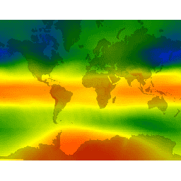
Данные спектрометра для картирования общего содержания озона (TOMS) представляют собой основную долгосрочную непрерывную запись спутниковых наблюдений, доступную для мониторинга глобальных и региональных тенденций изменения общего содержания озона за последние 25 лет. Данные создаются Лабораторией атмосферы в Центре космических полетов имени Годдарда НАСА. В версии 8 данные TOMS включают сеточные данные уровня 3 (1,0 x 1,25 градуса). Прибор для мониторинга озона (OMI) на борту спутника Aura (июль 2004 г. – настоящее время) имеет более высокое разрешение (1,0 x 1,0 градуса).
Эти данные представляют собой объединенный продукт по озону, полученный на основе данных TOMS/EarthProbe, TOMS/Nimbus-7, TOMS/Meteor-3, OMI/Aura и интерполированных данных USGS для дат, для которых данные отсутствуют.
Группы
Группы
Размер пикселя: 111000 метров (все диапазоны)
| Имя | Единицы | Мин | Макс | Размер пикселя | Описание |
|---|---|---|---|---|---|
ozone | Добсон | 73* | 983* | 111000 метров | Общее содержание озона в столбе атмосферы |
Условия эксплуатации
Условия эксплуатации
Распространение данных из Центра данных и информации по наукам о Земле имени Годдарда (GES DISC) финансируется Управлением научных миссий НАСА (SMD). В соответствии с Политикой НАСА в отношении данных и информации по наукам о Земле , данные из архива GES DISC доступны пользователям бесплатно. Для получения дополнительной информации посетите страницу Политики данных GES DISC.
Цитаты
При использовании данных необходимо надлежащим образом указывать источник набора данных. Формальная ссылка должна выглядеть следующим образом: \
NASA/GSFC, Гринбелт, Мэриленд, США, Центр данных и информации по наукам о Земле им. Годдарда (GES DISC). Доступно по адресу: \ в \
Исследуйте мир с помощью Earth Engine.
Редактор кода (JavaScript)
var dataset = ee.ImageCollection('TOMS/MERGED')
                  .filter(ee.Filter.date('2018-08-01', '2018-08-10'));
var columnOzone = dataset.select('ozone');
var columnOzoneVis = {
  min: 100,
  max: 500,
  palette: ['1621a2', 'cyan', 'green', 'yellow', 'orange', 'red'],
};
Map.setCenter(6.75, 46.53, 2);
Map.addLayer(columnOzone, columnOzoneVis, 'Column Ozone');