- ডেটাসেটের উপলভ্যতা
- 2017-06-01T00:00:00Z–2018-05-31T00:00:00Z
- ডেটাসেট প্রযোজক
- বিগআর্থনেট
- ট্যাগ
- চিপ
বর্ণনা
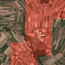
বিগআর্থনেট হলো একটি নতুন বৃহৎ আকারের সেন্টিনেল-২ বেঞ্চমার্ক আর্কাইভ, যা ৫৯০,৩২৬টি সেন্টিনেল-২ ইমেজ প্যাচ নিয়ে গঠিত। বিগআর্থনেট তৈরি করার জন্য, ২০১৭ সালের জুন থেকে ২০১৮ সালের মে মাসের মধ্যে ইউরোপের ১০টি দেশ (অস্ট্রিয়া, বেলজিয়াম, ফিনল্যান্ড, আয়ারল্যান্ড, কসোভো, লিথুয়ানিয়া, লুক্সেমবার্গ, পর্তুগাল, সার্বিয়া, সুইজারল্যান্ড) থেকে ১২৫টি সেন্টিনেল-২ টাইল সংগ্রহ করা হয়েছিল। সমস্ত টাইলগুলোকে সেন্টিনেল-২ লেভেল ২এ প্রোডাক্ট জেনারেশন অ্যান্ড ফরম্যাটিং টুল (sen2cor) দ্বারা বায়ুমণ্ডলীয়ভাবে সংশোধন করা হয়েছিল। এরপর, সেগুলোকে ৫৯০,৩২৬টি পরস্পর-অসংলগ্ন ইমেজ প্যাচে বিভক্ত করা হয়। প্রতিটি ইমেজ প্যাচকে ২০১৮ সালের CORINE ল্যান্ড কভার ডেটাবেস (CLC 2018) থেকে প্রাপ্ত একাধিক ভূমি-আচ্ছাদন শ্রেণি (অর্থাৎ, মাল্টি-লেবেল) দ্বারা টীকাযুক্ত করা হয়েছিল।
ব্যান্ড
ব্যান্ড
পিক্সেল আকার: পরিবর্তনশীল
| নাম | স্কেল | পিক্সেল আকার | তরঙ্গদৈর্ঘ্য | বর্ণনা |
|---|---|---|---|---|
B1 | ০.০০০১ | ৬০ মিটার | ৪৪৩.৯ ন্যানোমিটার (এস২এ) / ৪৪২.৩ ন্যানোমিটার (এস২বি) | অ্যারোসল |
B2 | ০.০০০১ | ১০ মিটার | ৪৯৬.৬ ন্যানোমিটার (এস২এ) / ৪৯২.১ ন্যানোমিটার (এস২বি) | নীল |
B3 | ০.০০০১ | ১০ মিটার | ৫৬০ ন্যানোমিটার (এস২এ) / ৫৫৯ ন্যানোমিটার (এস২বি) | সবুজ |
B4 | ০.০০০১ | ১০ মিটার | ৬৬৪.৫ ন্যানোমিটার (এস২এ) / ৬৬৫ ন্যানোমিটার (এস২বি) | লাল |
B5 | ০.০০০১ | ২০ মিটার | ৭০৩.৯ ন্যানোমিটার (এস২এ) / ৭০৩.৮ ন্যানোমিটার (এস২বি) | লাল প্রান্ত ১ |
B6 | ০.০০০১ | ২০ মিটার | ৭৪০.২ ন্যানোমিটার (এস২এ) / ৭৩৯.১ ন্যানোমিটার (এস২বি) | রেড এজ ২ |
B7 | ০.০০০১ | ২০ মিটার | ৭৮২.৫ ন্যানোমিটার (এস২এ) / ৭৭৯.৭ ন্যানোমিটার (এস২বি) | রেড এজ ৩ |
B8 | ০.০০০১ | ১০ মিটার | ৮৩৫.১ ন্যানোমিটার (এস২এ) / ৮৩৩ ন্যানোমিটার (এস২বি) | এনআইআর |
B9 | ০.০০০১ | ৬০ মিটার | ৯৪৫ ন্যানোমিটার (এস২এ) / ৯৪৩.২ ন্যানোমিটার (এস২বি) | জলীয় বাষ্প |
B10 | ০.০০০১ | ৬০ মিটার | 1373.5nm (S2A) / 1376.9nm (S2B) | সিরাস |
B11 | ০.০০০১ | ২০ মিটার | ১৬১৩.৭ ন্যানোমিটার (এস২এ) / ১৬১০.৪ ন্যানোমিটার (এস২বি) | SWIR 1 |
B12 | ০.০০০১ | ২০ মিটার | ২২০২.৪ ন্যানোমিটার (এস২এ) / ২১৮৫.৭ ন্যানোমিটার (এস২বি) | SWIR 2 |
B8A | ০.০০০১ | ২০ মিটার | ৮৬৪.৮ ন্যানোমিটার (এস২এ) / ৮৬৪ ন্যানোমিটার (এস২বি) | রেড এজ ৪ |
ছবির বৈশিষ্ট্য
ছবির বৈশিষ্ট্য
| নাম | প্রকার | বর্ণনা |
|---|---|---|
| লেবেল | স্ট্রিং_লিস্ট | এই ছবিতে পাওয়া ভূমির আচ্ছাদনের প্রকারভেদের তালিকা |
| উৎস | স্ট্রিং | সংশ্লিষ্ট সেন্টিনেল-২ ১সি ছবির প্রোডাক্ট আইডি |
| টাইল_এক্স | দ্বিগুণ | উৎস ছবিতে টাইলের X স্থানাঙ্ক |
| টাইল_ওয়াই | দ্বিগুণ | উৎস ছবিতে টাইলের Y স্থানাঙ্ক |
ব্যবহারের শর্তাবলী
ব্যবহারের শর্তাবলী
BigEarthNet আর্কাইভটি কমিউনিটি ডেটা লাইসেন্স এগ্রিমেন্ট - পারমিসিভ, ভার্সন ১.০-এর অধীনে লাইসেন্সপ্রাপ্ত। আরও তথ্যের জন্য, অনুগ্রহ করে https://cdla.dev/permissive-1-0 দেখুন।
উদ্ধৃতি
জি. সুমবুল, এম. চারফুয়েলান, বি. দেমির, ভি. মার্কল, বিগআর্থনেট: রিমোট সেন্সিং চিত্র অনুধাবনের জন্য একটি বৃহৎ-মাপের বেঞ্চমার্ক আর্কাইভ, আইইইই আন্তর্জাতিক ভূবিজ্ঞান ও রিমোট সেন্সিং সিম্পোজিয়াম, পৃষ্ঠা ৫৯০১-৫৯০৪, ইয়োকোহামা, জাপান, ২০১৯।
আর্থ ইঞ্জিনের সাহায্যে ঘুরে দেখুন
কোড এডিটর (জাভাস্ক্রিপ্ট)
var geometry = ee.Geometry.Polygon(
    [[
      [16.656886757418057, 48.27086673747943],
      [16.656886757418057, 48.21359065567954],
      [16.733276070162198, 48.21359065567954],
      [16.733276070162198, 48.27086673747943]]]);

var ic = ee.ImageCollection('TUBerlin/BigEarthNet/v1');

var filtered = ic.filterBounds(geometry);

var tiles = filtered.map(function(image) {
  var labels = ee.List(image.get('labels'));

  var urban = labels.indexOf('Discontinuous urban fabric').gte(0);
  var highlight_urban = ee.Image(urban).toInt().multiply(1000);

  return image.addBands(
      {srcImg: image.select(['B4']).add(highlight_urban), overwrite: true});
});

var image = tiles.mosaic().clip(geometry);

var visParams = {bands: ['B4', 'B3', 'B2'], min: 0, max: 3000};

Map.addLayer(image, visParams);
Map.centerObject(image, 13);