- Dostępność zbioru danych
- 2017-06-01T00:00:00Z–2018-05-31T00:00:00Z
- Dostawca zbioru danych
- BigEarthNet
- Tagi
Opis
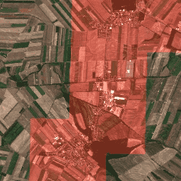
BigEarthNet to nowe, duże archiwum referencyjne Sentinel-2,które zawiera 590 326 fragmentów obrazów Sentinel-2. Do stworzenia zbioru BigEarthNet wykorzystano 125 obrazów Sentinel-2 pozyskanych w okresie od czerwca 2017 r. do maja 2018 r. nad 10 krajami Europy (Austrią, Belgią, Finlandią, Irlandią, Kosowem, Litwą, Luksemburgiem, Portugalią, Serbią i Szwajcarią). Wszystkie kafelki zostały skorygowane pod kątem atmosfery za pomocą narzędzia do generowania i formatowania produktów Sentinel-2 Level 2A (sen2cor). Następnie podzielono je na 590 326 niepokrywających się fragmentów obrazu. Każdy fragment obrazu został oznaczony wieloma klasami pokrycia terenu (czyli wieloma etykietami) pochodzącymi z bazy danych CORINE Land Cover z 2018 roku (CLC 2018).
Pasma
Pasma
Rozmiar piksela: zależy od modelu
| Nazwa | Skala | Rozmiar piksela | Długość fali | Opis |
|---|---|---|---|---|
B1 |
0,0001 | 60 metrów | 443,9 nm (S2A) / 442,3 nm (S2B) | Aerozole |
B2 |
0,0001 | 10 metrów | 496,6 nm (S2A) / 492,1 nm (S2B) | Niebieski |
B3 |
0,0001 | 10 metrów | 560 nm (S2A) / 559 nm (S2B) | Zielony |
B4 |
0,0001 | 10 metrów | 664,5 nm (S2A) / 665 nm (S2B) | Czerwony |
B5 |
0,0001 | 20 metrów | 703,9 nm (S2A) / 703,8 nm (S2B) | Red Edge 1 |
B6 |
0,0001 | 20 metrów | 740,2 nm (S2A) / 739,1 nm (S2B) | Red Edge 2 |
B7 |
0,0001 | 20 metrów | 782,5 nm (S2A) / 779,7 nm (S2B) | Red Edge 3 |
B8 |
0,0001 | 10 metrów | 835,1 nm (S2A) / 833 nm (S2B) | NIR |
B9 |
0,0001 | 60 metrów | 945 nm (S2A) / 943,2 nm (S2B) | Para wodna |
B10 |
0,0001 | 60 metrów | 1373,5 nm (S2A) / 1376,9 nm (S2B) | Cirrus |
B11 |
0,0001 | 20 metrów | 1613,7 nm (S2A) / 1610,4 nm (S2B) | SWIR 1 |
B12 |
0,0001 | 20 metrów | 2202,4 nm (S2A) / 2185,7 nm (S2B) | SWIR 2 |
B8A |
0,0001 | 20 metrów | 864,8 nm (S2A) / 864 nm (S2B) | Red Edge 4 |
Właściwości obrazu
Właściwości obrazu
| Nazwa | Typ | Opis |
|---|---|---|
| etykiety | CIĄG ZNAKÓW_LISTA | Lista typów pokrycia terenu znalezionych na tym obrazie |
| źródło | CIĄG ZNAKÓW | Identyfikator produktu odpowiadający obrazowi Sentinel-2 1C |
| tile_x | LICZBA ZMIENNOPRZECINKOWA O PODWÓJNEJ PRECYZJI | Współrzędna X kafelka w obrazie źródłowym. |
| tile_y | LICZBA ZMIENNOPRZECINKOWA O PODWÓJNEJ PRECYZJI | Współrzędna Y kafelka w obrazie źródłowym |
Warunki korzystania z usługi
Warunki korzystania z usługi
Archiwum BigEarthNet jest udostępniane na podstawie licencji Community Data License Agreement – Permissive, wersja 1.0. Więcej informacji znajdziesz na stronie https://cdla.dev/permissive-1-0.
Cytaty
G. Sumbul, M. Charfuelan, B. Demir, V. Markl, BigEarthNet: A Large-Scale Benchmark Archive for Remote Sensing Image Understanding, IEEE International Conference on Geoscience and Remote Sensing Symposium, s. 5901–5904, Jokohama, Japonia, 2019 r.
Odkrywaj za pomocą Earth Engine
Edytor kodu (JavaScript)
var geometry = ee.Geometry.Polygon(
    [[
      [16.656886757418057, 48.27086673747943],
      [16.656886757418057, 48.21359065567954],
      [16.733276070162198, 48.21359065567954],
      [16.733276070162198, 48.27086673747943]]]);

var ic = ee.ImageCollection('TUBerlin/BigEarthNet/v1');

var filtered = ic.filterBounds(geometry);

var tiles = filtered.map(function(image) {
  var labels = ee.List(image.get('labels'));

  var urban = labels.indexOf('Discontinuous urban fabric').gte(0);
  var highlight_urban = ee.Image(urban).toInt().multiply(1000);

  return image.addBands(
      {srcImg: image.select(['B4']).add(highlight_urban), overwrite: true});
});

var image = tiles.mosaic().clip(geometry);

var visParams = {bands: ['B4', 'B3', 'B2'], min: 0, max: 3000};

Map.addLayer(image, visParams);
Map.centerObject(image, 13);