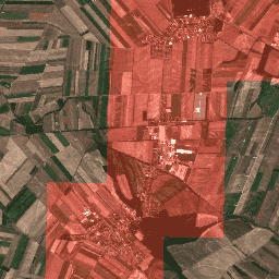
O BigEarthNet é um novo arquivo de comparativo do Sentinel-2 em grande escala, composto por 590.326 patches de imagens do Sentinel-2. Para criar o BigEarthNet, foram adquiridos 125 blocos do Sentinel-2 entre junho de 2017 e maio de 2018 nos 10 países da Europa (Áustria, Bélgica, Finlândia, Irlanda, Kosovo, Lituânia, Luxemburgo, Portugal, Sérvia e Suíça). Todos os blocos foram corrigidos atmosfericamente pela ferramenta de geração e formatação de produtos do Nível 2A da Sentinel-2 (sen2cor). Em seguida, eles foram divididos em 590.326 patches de imagem não sobrepostos. Cada patch de imagem foi anotado pelas várias classes de cobertura do solo (ou seja, vários rótulos) fornecidas pelo banco de dados CORINE Land Cover de 2018 (CLC 2018).
Bandas
Bandas
Nome
Escala
Tamanho do pixel
Comprimento de onda
Descrição
B1
0,0001
60 metros
443,9 nm (S2A) / 442,3 nm (S2B)
Aerossóis
B2
0,0001
10 metros
496,6 nm (S2A) / 492,1 nm (S2B)
Azul
B3
0,0001
10 metros
560nm (S2A) / 559nm (S2B)
Verde
B4
0,0001
10 metros
664,5 nm (S2A) / 665 nm (S2B)
Vermelho
B5
0,0001
20 metros
703,9 nm (S2A) / 703,8 nm (S2B)
Borda vermelha 1
B6
0,0001
20 metros
740,2 nm (S2A) / 739,1 nm (S2B)
Red Edge 2
B7
0,0001
20 metros
782,5 nm (S2A) / 779,7 nm (S2B)
Borda vermelha 3
B8
0,0001
10 metros
835,1 nm (S2A) / 833 nm (S2B)
NIR
B9
0,0001
60 metros
945 nm (S2A) / 943,2 nm (S2B)
Vapor de água
B10
0,0001
60 metros
1373,5 nm (S2A) / 1376,9 nm (S2B)
Cirro
B11
0,0001
20 metros
1613,7 nm (S2A) / 1610,4 nm (S2B)
SWIR 1
B12
0,0001
20 metros
2202,4 nm (S2A) / 2185,7 nm (S2B)
SWIR 2
B8A
0,0001
20 metros
864,8 nm (S2A) / 864 nm (S2B)
Red Edge 4
Propriedades de imagens
Propriedades da imagem
Nome
Tipo
Descrição
rótulos
STRING_LIST
Lista de tipos de cobertura do solo encontrados nesta imagem
source
STRING
ID do produto da imagem Sentinel-2 1C correspondente.
tile_x
DOUBLE
Coordenada X do bloco na imagem de origem
tile_y
DOUBLE
Coordenada Y do bloco na imagem de origem
Termos de Uso
Termos de Uso
O arquivo BigEarthNet está licenciado de acordo com o Community Data License Agreement - Permissive, versão 1.0. Para mais informações, consulte https://cdla.dev/permissive-1-0.
Citações
Citações:
G. Sumbul, M. Charfuelan, B. Demir, V. Markl, BigEarthNet: A Large-Scale Benchmark Archive for Remote Sensing Image Understanding, IEEE International Conference on Geoscience and Remote Sensing Symposium, pp. 5901-5904, Yokohama, Japão, 2019.
O BigEarthNet é um novo arquivo de comparativo de mercado do Sentinel-2 em grande escala, composto por 590.326 patches de imagens do Sentinel-2. Para criar o BigEarthNet, 125 blocos do Sentinel-2 foram adquiridos entre junho de 2017 e maio de 2018 nos 10 países da Europa (Áustria, Bélgica, Finlândia, Irlanda, Kosovo, Lituânia, Luxemburgo, Portugal, Sérvia e Suíça). Todas as imagens foram corrigidas atmosfericamente…
[null,null,[],[[["\u003cp\u003eBigEarthNet is a large-scale Sentinel-2 benchmark archive containing 590,326 image patches acquired between June 2017 and May 2018.\u003c/p\u003e\n"],["\u003cp\u003eIt covers 10 European countries (Austria, Belgium, Finland, Ireland, Kosovo, Lithuania, Luxembourg, Portugal, Serbia, Switzerland) and is based on 125 Sentinel-2 tiles.\u003c/p\u003e\n"],["\u003cp\u003eEach image patch is annotated with multiple land-cover classes from the CORINE Land Cover database of 2018 (CLC 2018).\u003c/p\u003e\n"],["\u003cp\u003eBigEarthNet provides Sentinel-2 Level 2A product image patches, atmospherically corrected by sen2cor.\u003c/p\u003e\n"],["\u003cp\u003eThe archive is licensed under the Community Data License Agreement - Permissive, Version 1.0.\u003c/p\u003e\n"]]],[],null,["# TUBerlin/BigEarthNet/v1\n\nDataset Availability\n: 2017-06-01T00:00:00Z--2018-05-31T00:00:00Z\n\nDataset Provider\n:\n\n\n [BigEarthNet](http://bigearth.net/)\n\nTags\n:\n [copernicus](/earth-engine/datasets/tags/copernicus) [landuse-landcover](/earth-engine/datasets/tags/landuse-landcover) [sentinel](/earth-engine/datasets/tags/sentinel) \n chip \n corine-derived \n label \n ml \ntile \n\n#### Description\n\nBigEarthNet is a new large-scale Sentinel-2 benchmark archive, consisting of\n590,326 Sentinel-2 image patches. To construct BigEarthNet, 125 Sentinel-2\ntiles were acquired between June 2017 and May 2018 over the 10 countries\n(Austria, Belgium, Finland, Ireland, Kosovo, Lithuania, Luxembourg,\nPortugal, Serbia, Switzerland) of Europe. All the tiles were atmospherically\ncorrected by the Sentinel-2 Level 2A product generation and formatting tool\n(sen2cor). Then, they were divided into 590,326 non-overlapping image\npatches. Each image patch was annotated by the multiple land-cover classes\n(i.e., multi-labels) that were provided from the CORINE Land Cover database\nof the year 2018 (CLC 2018).\n\n### Bands\n\n**Bands**\n\n| Name | Scale | Pixel Size | Wavelength | Description |\n|-------|--------|------------|---------------------------------|-------------|\n| `B1` | 0.0001 | 60 meters | 443.9nm (S2A) / 442.3nm (S2B) | Aerosols |\n| `B2` | 0.0001 | 10 meters | 496.6nm (S2A) / 492.1nm (S2B) | Blue |\n| `B3` | 0.0001 | 10 meters | 560nm (S2A) / 559nm (S2B) | Green |\n| `B4` | 0.0001 | 10 meters | 664.5nm (S2A) / 665nm (S2B) | Red |\n| `B5` | 0.0001 | 20 meters | 703.9nm (S2A) / 703.8nm (S2B) | Red Edge 1 |\n| `B6` | 0.0001 | 20 meters | 740.2nm (S2A) / 739.1nm (S2B) | Red Edge 2 |\n| `B7` | 0.0001 | 20 meters | 782.5nm (S2A) / 779.7nm (S2B) | Red Edge 3 |\n| `B8` | 0.0001 | 10 meters | 835.1nm (S2A) / 833nm (S2B) | NIR |\n| `B9` | 0.0001 | 60 meters | 945nm (S2A) / 943.2nm (S2B) | Water vapor |\n| `B10` | 0.0001 | 60 meters | 1373.5nm (S2A) / 1376.9nm (S2B) | Cirrus |\n| `B11` | 0.0001 | 20 meters | 1613.7nm (S2A) / 1610.4nm (S2B) | SWIR 1 |\n| `B12` | 0.0001 | 20 meters | 2202.4nm (S2A) / 2185.7nm (S2B) | SWIR 2 |\n| `B8A` | 0.0001 | 20 meters | 864.8nm (S2A) / 864nm (S2B) | Red Edge 4 |\n\n### Image Properties\n\n**Image Properties**\n\n| Name | Type | Description |\n|--------|-------------|-----------------------------------------------------|\n| labels | STRING_LIST | List of landcover types found in this image |\n| source | STRING | Product ID of the corresponding Sentinel-2 1C image |\n| tile_x | DOUBLE | X coordinate of tile in source image |\n| tile_y | DOUBLE | Y coordinate of tile in source image |\n\n### Terms of Use\n\n**Terms of Use**\n\nThe BigEarthNet Archive is licensed under the Community Data License\nAgreement - Permissive, Version 1.0. For more information,\nplease refer to\n[https://cdla.dev/permissive-1-0](https://cdla.dev/permissive-1-0/).\n\n### Citations\n\nCitations:\n\n- G. Sumbul, M. Charfuelan, B. Demir, V. Markl, BigEarthNet: A Large-Scale\n Benchmark Archive for Remote Sensing Image Understanding, IEEE International\n Conference on Geoscience and Remote Sensing Symposium, pp. 5901-5904,\n Yokohama, Japan, 2019.\n\n### Explore with Earth Engine\n\n| **Important:** Earth Engine is a platform for petabyte-scale scientific analysis and visualization of geospatial datasets, both for public benefit and for business and government users. Earth Engine is free to use for research, education, and nonprofit use. To get started, please [register for Earth Engine access.](https://console.cloud.google.com/earth-engine)\n\n### Code Editor (JavaScript)\n\n```javascript\nvar geometry = ee.Geometry.Polygon(\n [[\n [16.656886757418057, 48.27086673747943],\n [16.656886757418057, 48.21359065567954],\n [16.733276070162198, 48.21359065567954],\n [16.733276070162198, 48.27086673747943]]]);\n\nvar ic = ee.ImageCollection('TUBerlin/BigEarthNet/v1');\n\nvar filtered = ic.filterBounds(geometry);\n\nvar tiles = filtered.map(function(image) {\n var labels = ee.List(image.get('labels'));\n\n var urban = labels.indexOf('Discontinuous urban fabric').gte(0);\n var highlight_urban = ee.Image(urban).toInt().multiply(1000);\n\n return image.addBands(\n {srcImg: image.select(['B4']).add(highlight_urban), overwrite: true});\n});\n\nvar image = tiles.mosaic().clip(geometry);\n\nvar visParams = {bands: ['B4', 'B3', 'B2'], min: 0, max: 3000};\n\nMap.addLayer(image, visParams);\nMap.centerObject(image, 13);\n```\n[Open in Code Editor](https://code.earthengine.google.com/?scriptPath=Examples:Datasets/TUBerlin/TUBerlin_BigEarthNet_v1) \n[TUBerlin/BigEarthNet/v1](/earth-engine/datasets/catalog/TUBerlin_BigEarthNet_v1) \nBigEarthNet is a new large-scale Sentinel-2 benchmark archive, consisting of 590,326 Sentinel-2 image patches. To construct BigEarthNet, 125 Sentinel-2 tiles were acquired between June 2017 and May 2018 over the 10 countries (Austria, Belgium, Finland, Ireland, Kosovo, Lithuania, Luxembourg, Portugal, Serbia, Switzerland) of Europe. All the tiles were atmospherically corrected ... \nTUBerlin/BigEarthNet/v1, copernicus,landuse-landcover,sentinel \n2017-06-01T00:00:00Z/2018-05-31T00:00:00Z \n36.9 -9 68.1 31.6 \nGoogle Earth Engine \nhttps://developers.google.com/earth-engine/datasets\n\n- [](https://doi.org/http://bigearth.net/)\n- [](https://doi.org/https://developers.google.com/earth-engine/datasets/catalog/TUBerlin_BigEarthNet_v1)"]]