- 데이터 세트 제공
- 2018-01-01T00:00:00Z–2019-01-01T00:00:00Z
- 데이터 세트 출처
- 칭화대학교 지구 시스템 과학부 (DESS, THU)
- 태그
설명
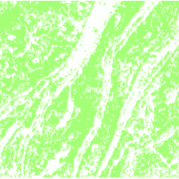
이 데이터 세트는 2018년 30m 해상도의 중국 계단식 논 지도입니다. 이 모델은 Google Earth Engine 플랫폼을 기반으로 멀티 소스 및 멀티 시간 데이터를 사용하여 감독된 픽셀 기반 분류를 통해 개발되었습니다. 전체 정확도와 카파 계수는 각각 94%, 0.72를 달성했습니다. 이 첫 번째 30m 중국 계단식 논 지도에서는 토양 침식, 식량 안보, 생지화학적 순환, 생물 다양성, 생태계 서비스 평가에 관한 연구에 사용할 수 있습니다.
대역
대역
픽셀 크기: 30미터 (모든 밴드)
| 이름 | 픽셀 크기 | 설명 |
|---|---|---|
terrace |
30m | 테라스가 있으면 1, 없으면 0입니다. |
terrace Class Table
| 값 | 색상 | 설명 |
|---|---|---|
| 0 | #ffffff | 테라스 없음 |
| 1 | #a3ff74 | 테라스 있음 |
이용약관
이용약관
인용
인용:
Cao, B., Yu, L., Naipal, V., Ciais, P., Li, W., Zhao, Y., Wei, W., Chen, D., Liu, Z., and Gong, P.: Landsat 8 이미지와 Google Earth Engine을 기반으로 한 디지털 고도 모델을 사용한 중국의 30m 계단식 논 매핑, Earth Syst. Sci. Data, 13, 2437-2456, doi:10.5194/essd-13-2437-2021, 2021.
DOI
Earth Engine으로 탐색
코드 편집기(JavaScript)
var image = ee.Image('Tsinghua/DESS/ChinaTerraceMap/v1');

var image = image.updateMask(image);
Map.addLayer(image, {min: 0, max: 1, palette: ['a3ff74']}, 'Terraces');

Map.setCenter(106.6, 30.4, 10);
Map.setOptions('SATELLITE');