- Disponibilidade de conjuntos de dados
- 1985-01-01T00:00:00Z–2018-12-31T00:00:00Z
- Provedor de conjunto de dados
- Universidade Tsinghua
- Tags
Descrição
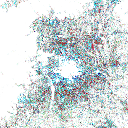
Esse conjunto de dados contém informações sobre a mudança anual da área de superfície impermeável global de 1985 a 2018 com uma resolução de 30 m. A mudança de permeável para impermeável foi determinada usando uma abordagem combinada de classificação supervisionada e verificação de consistência temporal. Pixels impermeáveis são definidos como acima de 50% de impermeabilidade. O ano da transição (de permeável para impermeável) pode ser identificado pelo valor do pixel, que varia de 34 (ano: 1985) a 1 (ano: 2018). Por exemplo, a superfície impermeável em 1990 pode ser revelada como o valor do pixel maior que 29 (consulte a tabela de pesquisa). Esse conjunto de dados é temporalmente consistente, seguindo a conversão de pervious (por exemplo, não urbano) para impervious (por exemplo, urbano) monotonicamente. Para mais informações sobre a abordagem de mapeamento e a avaliação, consulte Mapas anuais da área artificial impermeável global (GAIA) entre 1985 e 2018 (Gong et al. 2020).
Bandas
Tamanho do pixel
30 metros
Bandas
| Nome | Mín. | Máx. | Tamanho do pixel | Descrição |
|---|---|---|---|---|
change_year_index |
1* | 34* | metros | Ano da transição de permeável para impermeável. De 34 (ano: 1985) a 1 (ano: 2018) |
Tabela de classe change_year_index
| Valor | Cor | Descrição |
|---|---|---|
| 1 | #014352 | 2018 |
| 2 | #1a492c | 2017 |
| 3 | #071ec4 | 2016 |
| 4 | #b5ca36 | 2015 |
| 5 | #729eac | 2014 |
| 6 | #8ea5de | 2013 |
| 7 | #818991 | 2012 |
| 8 | #62a3c3 | 2011 |
| 9 | #ccf4fe | 2010 |
| 10 | #74f0b9 | 2009 |
| 11 | #32bc55 | 2008 |
| 12 | #c72144 | 2007 |
| 13 | #56613b | 2006 |
| 14 | #c14683 | 2005 |
| 15 | #c31c25 | 2004 |
| 16 | #5f6253 | 2003 |
| 17 | #11bf85 | 2002 |
| 18 | #a61b26 | 2001 |
| 19 | #99fbc5 | 2000 |
| 20 | #188aaa | 1999 |
| 21 | #c2d7f1 | 1998 |
| 22 | #b7d9d8 | 1997 |
| 23 | #856f96 | 1996 |
| 24 | #109c6b | 1995 |
| 25 | #2de3f4 | 1994 |
| 26 | #9a777d | 1993 |
| 27 | #151796 | 1992 |
| 28 | #c033d8 | 1991 |
| 29 | #510037 | 1990 |
| 30 | #640c21 | 1989 |
| 31 | #31a191 | 1988 |
| 32 | #223ab0 | 1987 |
| 33 | #b692ac | 1986 |
| 34 | #2de3f4 | 1985 |
Termos de Uso
Termos de Uso
Este trabalho está licenciado sob uma Licença Creative Commons Atribuição 4.0 Internacional. https://creativecommons.org/licenses/by/4.0/
Citações
Gong, P., Li, X., Wang, J., Bai, Y., Chen, B., Hu, T., ... & Zhou, Y. (2020). Mapas anuais da área artificial impermeável global (GAIA, na sigla em inglês) entre 1985 e 2018. Remote Sensing of Environment, 236, 111510.
Explorar com o Earth Engine
Editor de código (JavaScript)
var dataset = ee.Image('Tsinghua/FROM-GLC/GAIA/v10');

var visualization = {
  bands: ['change_year_index'],
  min: 0,
  max: 34,
  palette: [
    '014352', '1a492c', '071ec4', 'b5ca36', '729eac', '8ea5de',
    '818991', '62a3c3', 'ccf4fe', '74f0b9', '32bc55', 'c72144',
    '56613b', 'c14683', 'c31c25', '5f6253', '11bf85', 'a61b26',
    '99fbc5', '188aaa', 'c2d7f1', 'b7d9d8', '856f96', '109c6b',
    '2de3f4', '9a777d', '151796', 'c033d8', '510037', '640c21',
    '31a191', '223ab0', 'b692ac', '2de3f4',
  ]
};

Map.setCenter(-37.62, 25.8, 2);

Map.addLayer(dataset, visualization, 'Change year index');