기후 위험 센터 적외선 강수량 (CHIRPS)은 30년 이상 된 준전 세계 강수량 데이터 세트입니다. CHIRPS는 0.05° 해상도 위성 이미지를 현장 관측소 데이터와 통합하여 추세 분석 및 계절별 가뭄 모니터링을 위한 그리드 강수량 시계열을 생성합니다.
대역
픽셀 크기 5566미터
대역
이름
단위
최소
최대
픽셀 크기
설명
precipitation
mm/pentad
0*
1072.43*
미터
강수량
* 예상 최솟값 또는 최댓값
이미지 속성
이미지 속성
이름
유형
설명
월
DOUBLE
월
5개
DOUBLE
Pentad
년
DOUBLE
연도
이용약관
이용약관
이 데이터 세트는 공개 도메인에 있습니다. 법률에 따라 허용되는 범위 내에서 Pete Peterson은 기상 관측소의 적외선 강수량 (CHIRPS)에 대한 모든 저작권 및 관련 권리 또는 인접 권리를 포기했습니다.
인용
인용:
Funk, Chris, Pete Peterson, Martin Landsfeld, Diego Pedreros, James
Verdin, Shraddhanand Shukla, Gregory Husak, James Rowland, Laura Harrison,
Andrew Hoell & Joel Michaelsen. 'The climate hazards infrared precipitation with stations-a new environmental record for monitoring extremes'.
Scientific Data 2, 150066. doi:10.1038/sdata.2015.66
2015.
Climate Hazards Center InfraRed Precipitation with Station data (CHIRPS)는 30년 이상 된 준전역 강우량 데이터 세트입니다. CHIRPS는 0.05° 해상도 위성 이미지를 현장 관측소 데이터와 통합하여 추세 분석 및 계절별 가뭄 모니터링을 위한 그리드 강우량 시계열을 생성합니다.
[null,null,[],[[["\u003cp\u003eCHIRPS is a 30+ year quasi-global rainfall dataset spanning from 1981 to 2024.\u003c/p\u003e\n"],["\u003cp\u003eIt combines 0.05° resolution satellite imagery and in-situ station data for gridded rainfall analysis.\u003c/p\u003e\n"],["\u003cp\u003eThis dataset is freely available for research, education, and non-profit use.\u003c/p\u003e\n"],["\u003cp\u003eCHIRPS enables trend analysis and seasonal drought monitoring.\u003c/p\u003e\n"],["\u003cp\u003eThe data is provided in pentad (5-day) increments and includes precipitation measurements in mm/pentad.\u003c/p\u003e\n"]]],[],null,["# CHIRPS Pentad: Climate Hazards Center InfraRed Precipitation With Station Data (Version 2.0 Final)\n\nDataset Availability\n: 1981-01-01T00:00:00Z--2025-07-26T00:00:00Z\n\nDataset Provider\n:\n\n\n [UCSB/CHG](https://chc.ucsb.edu/data/chirps)\n\nCadence\n: 1 Custom_time_unit\n\nTags\n:\n[chg](/earth-engine/datasets/tags/chg) [climate](/earth-engine/datasets/tags/climate) [geophysical](/earth-engine/datasets/tags/geophysical) [precipitation](/earth-engine/datasets/tags/precipitation) [ucsb](/earth-engine/datasets/tags/ucsb) [weather](/earth-engine/datasets/tags/weather) \n\n#### Description\n\nClimate Hazards Center InfraRed Precipitation with Station data (CHIRPS)\nis a 30+ year quasi-global rainfall dataset. CHIRPS incorporates\n0.05° resolution satellite imagery with in-situ station data\nto create gridded rainfall time series for trend analysis and seasonal\ndrought monitoring.\n\n### Bands\n\n\n**Pixel Size**\n\n5566 meters\n\n**Bands**\n\n| Name | Units | Min | Max | Pixel Size | Description |\n|-----------------|-----------|-----|-----------|------------|---------------|\n| `precipitation` | mm/pentad | 0\\* | 1072.43\\* | meters | Precipitation |\n\n\\* estimated min or max value\n\n### Image Properties\n\n**Image Properties**\n\n| Name | Type | Description |\n|--------|--------|-------------|\n| month | DOUBLE | Month |\n| pentad | DOUBLE | Pentad |\n| year | DOUBLE | Year |\n\n### Terms of Use\n\n**Terms of Use**\n\nThis datasets are in the public domain. To the extent possible under law,\n[Pete Peterson](https://chc.ucsb.edu/people/pete-peterson)\nhas waived all copyright and related or neighboring rights to\nClimate Hazards Center Infrared Precipitation with Stations (CHIRPS).\n\n### Citations\n\nCitations:\n\n- Funk, Chris, Pete Peterson, Martin Landsfeld, Diego Pedreros, James\n Verdin, Shraddhanand Shukla, Gregory Husak, James Rowland, Laura Harrison,\n Andrew Hoell \\& Joel Michaelsen. \"The climate hazards infrared precipitation\n with stations-a new environmental record for monitoring extremes\".\n Scientific Data 2, 150066. [doi:10.1038/sdata.2015.66](https://doi.org/10.1038/sdata.2015.66)\n 2015.\n\n### Explore with Earth Engine\n\n| **Important:** Earth Engine is a platform for petabyte-scale scientific analysis and visualization of geospatial datasets, both for public benefit and for business and government users. Earth Engine is free to use for research, education, and nonprofit use. To get started, please [register for Earth Engine access.](https://console.cloud.google.com/earth-engine)\n\n### Code Editor (JavaScript)\n\n```javascript\n
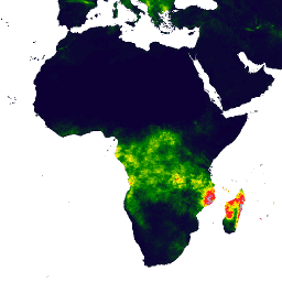
var dataset = ee.ImageCollection('UCSB-CHG/CHIRPS/PENTAD')\n .filter(ee.Filter.date('2018-05-01', '2018-05-05'));\nvar precipitation = dataset.select('precipitation');\nvar precipitationVis = {\n min: 0,\n max: 112,\n palette: ['001137', '0aab1e', 'e7eb05', 'ff4a2d', 'e90000'],\n};\nMap.setCenter(17.93, 7.71, 2);\nMap.addLayer(precipitation, precipitationVis, 'Precipitation');\n```\n[Open in Code Editor](https://code.earthengine.google.com/?scriptPath=Examples:Datasets/UCSB-CHG/UCSB-CHG_CHIRPS_PENTAD) \n[CHIRPS Pentad: Climate Hazards Center InfraRed Precipitation With Station Data (Version 2.0 Final)](/earth-engine/datasets/catalog/UCSB-CHG_CHIRPS_PENTAD) \nClimate Hazards Center InfraRed Precipitation with Station data (CHIRPS) is a 30+ year quasi-global rainfall dataset. CHIRPS incorporates 0.05° resolution satellite imagery with in-situ station data to create gridded rainfall time series for trend analysis and seasonal drought monitoring. \nUCSB-CHG/CHIRPS/PENTAD, chg,climate,geophysical,precipitation,ucsb,weather \n1981-01-01T00:00:00Z/2025-07-26T00:00:00Z \n-50 -180 50 180 \nGoogle Earth Engine \nhttps://developers.google.com/earth-engine/datasets\n\n- [](https://doi.org/https://chc.ucsb.edu/data/chirps)\n- [](https://doi.org/https://developers.google.com/earth-engine/datasets/catalog/UCSB-CHG_CHIRPS_PENTAD)"]]