- مدى توفّر مجموعة البيانات
- 1983-01-01T00:00:00Z–2016-12-31T00:00:00Z
- الجهة المنتِجة لمجموعة البيانات
- UCSB
- وتيرة تحديث البيانات
- يوم واحد
- العلامات
الوصف
تم تطوير مجموعة بيانات CHC-CMIP6 بشكل صريح لدعم تحليل المخاطر المتعلّقة بالمناخ خلال الماضي القريب وفي المستقبل القريب.
تحتوي مجموعة بيانات توقعات المناخ هذه على بيانات عالمية يومية مقسّمة إلى شبكات للفترات المرصودة (1983-2016) والمتوقّعة (2030 و2050) لاستخدامها في تحديد ومراقبة الظواهر الجوية المائية المتطرفة. تحتوي مجموعة البيانات على شبكات عالمية يومية عالية الدقة (0.05 درجة) لمنتج درجة الحرارة "درجة حرارة الأشعة تحت الحمراء لمخاطر المناخ مع المحطات" (CHIRTS-daily)، ومنتج هطول الأمطار "هطول الأمطار بالأشعة تحت الحمراء لمخاطر المناخ مع المحطات" (CHIRPS)، والرطوبة النسبية المستمدّة من ERA5، والتي تم منها استخلاص "عجز ضغط البخار" (VPD) و"أقصى درجة حرارة لمقياس الحرارة الرطب" (WBGTmax).
تم استخدام مجموعات كبيرة من نماذج CMIP6 من سيناريوهات "المسار الاجتماعي والاقتصادي المشترك" (SSP) 245 وSSP 585 لتطوير حقول دلتا عالية الدقة (0.05 درجة) يوميًا لعامَي 2030 و2050.
لمزيد من المعلومات، يُرجى الاطّلاع على مشروع مقارنة النماذج المقترنة في المرحلة 6 (CHC-CMIP6) التابع لمركز مخاطر المناخ (CHC).
النطاقات
النطاقات
حجم البكسل: 5566 مترًا (جميع النطاقات)
| الاسم | الوحدات | الحد الأدنى | الحد الأقصى | حجم البكسل | الوصف |
|---|---|---|---|---|---|
CHIRPS |
mm/d | 0 | 751.05 | 5566 مترًا | إجمالي الهطول اليومي |
himax |
°مئوية | -49.76 | 78.56 | 5566 مترًا | الحد الأقصى اليومي لمؤشر الحرارة |
RH |
% | -1.33 | 100 | 5566 مترًا | الرطوبة النسبية |
RHx |
% | -3.11 | 100 | 5566 مترًا | الرطوبة النسبية في الساعة التي تسجّل أعلى درجة حرارة |
RHn |
% | -2.603 | 100 | 5566 مترًا | الرطوبة النسبية في الساعة التي تسجّل أدنى درجة حرارة |
wbgtmax |
°مئوية | -100.54 | 33.76 | 5566 مترًا | الحد الأقصى اليومي لدرجة حرارة البصيلة الرطبة الكروية |
vpd |
كيلو باسكال | 0 | 67.98 | 5566 مترًا | عجز ضغط البخار اليومي |
svp |
كيلو باسكال | 0.011 | 71.41 | 5566 مترًا | متوسط ضغط بخار الماء المشبّع اليومي |
Tmax |
°مئوية | -43.04 | 90.52 | 5566 مترًا | الحد الأقصى اليومي لدرجة حرارة الهواء بالقرب من السطح |
Tmin |
°مئوية | -46.72 | 89.82 | 5566 مترًا | الحد الأدنى اليومي لدرجة حرارة الهواء بالقرب من السطح |
خصائص الصور
خصائص الصور
| الاسم | النوع | الوصف |
|---|---|---|
| projection_year | INT | سنة التوقّع |
| سيناريو | سلسلة | سيناريوهات المسار الاجتماعي والاقتصادي المشترك (SSP) |
بنود الاستخدام
بنود الاستخدام
تخضع مجموعة البيانات لترخيص المشاع الإبداعي مع نسب العمل إلى مؤلفه 4.0 International (CC BY 4.0). لمزيد من المعلومات، يُرجى الاطّلاع على مشروع مقارنة النماذج المقترنة في المرحلة 6 (CHC-CMIP6) التابع لمركز مخاطر المناخ (CHC).
الاقتباسات
Williams, E., Funk, C., Peterson, P., & Tuholske, C. (2024). ملاحظات وتوقعات عالية الدقة بشأن التغيرات المناخية لتقييم الظواهر الجوية القصوى المرتبطة بالحرارة Scientific Data, 11(1), 261. https://www.nature.com/articles/s41597-024-03074-w 2015.
الاستكشاف باستخدام Earth Engine
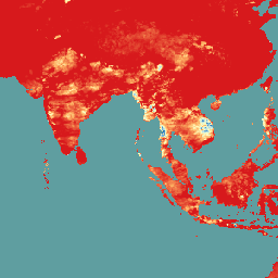
أداة تعديل الرموز (JavaScript)
var dataset = ee.ImageCollection('UCSB/CHC/CMIP6/v1')
                  .filter(ee.Filter.date('2016-08-01', '2016-08-30'));
var chirps = dataset.select('CHIRPS');
var chirpsVis = {
  min: 0,
  max: 100.0,
  palette: ['d7191c', 'fdae61', 'ffffbf', 'abd9e9', '2c7bb6'],
};
Map.setCenter(93.17, 10.14, 4);
Map.addLayer(chirps, chirpsVis, 'CHC CMIP6');