- ডেটাসেট উপলব্ধতা
- 2001-01-01T00:00:00Z-2002-01-01T00:00:00Z
- ডেটাসেট প্রদানকারী
- UMD/GLAD
- ট্যাগ
- খুশি
বর্ণনা
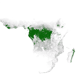
প্রাথমিক আর্দ্র গ্রীষ্মমন্ডলীয় বনগুলি অসংখ্য বৈশ্বিক ইকোসিস্টেম পরিষেবা প্রদান করে, কিন্তু অর্থনৈতিক চালকদের কাছ থেকে অব্যাহতির হুমকির মধ্যে রয়েছে। অর্থনৈতিক উন্নয়ন এবং ইকোসিস্টেম পরিষেবাগুলির রক্ষণাবেক্ষণের লক্ষ্যে জাতীয় ভূমি ব্যবহারের পরিকল্পনা এবং ভারসাম্য বজায় রাখার জন্য, UMD GLAD টিম দ্বারা একটি প্রাথমিক আর্দ্র গ্রীষ্মমন্ডলীয় বন মানচিত্র তৈরি করা হয়েছিল। বিশ্বব্যাপী অর্জিত, বিনামূল্যে, এবং ধারাবাহিকভাবে প্রক্রিয়াকৃত ল্যান্ডস্যাট চিত্র ব্যবহার করে 2001 সালের জন্য প্রাথমিক বনের ক্ষেত্রটি 30 মিটারের একটি স্থানিক রেজোলিউশনে ম্যাপ করা হয়েছিল।
ব্যান্ড
পিক্সেল সাইজ
30 মিটার
ব্যান্ড
| নাম | পিক্সেল সাইজ | বর্ণনা |
|---|---|---|
Primary_HT_forests | মিটার | প্রাথমিক আর্দ্র গ্রীষ্মমন্ডলীয় বন |
প্রাইমারি_এইচটি_ফরেস্ট ক্লাস টেবিল
| মান | রঙ | বর্ণনা |
|---|---|---|
| 1 | #008000 | প্রাথমিক আর্দ্র গ্রীষ্মমন্ডলীয় বন |
ব্যবহারের শর্তাবলী
ব্যবহারের শর্তাবলী
ডেটা অনুমতি, লাইসেন্স বা রয়্যালটি পেমেন্ট ছাড়াই যে কেউ, যে কোনও জায়গায়, যে কোনও সময় ব্যবহার করতে পারে। প্রস্তাবিত উদ্ধৃতি ব্যবহার করে বৈশিষ্ট্য অনুরোধ করা হয়.
উদ্ধৃতি
তুরুবানোয়া এস., পোটাপভ পি., টিউকাভিনা, এ., এবং হ্যানসেন এম. (2018) ব্রাজিল, কঙ্গো গণতান্ত্রিক প্রজাতন্ত্র এবং ইন্দোনেশিয়ায় চলমান প্রাথমিক বনের ক্ষতি। এনভায়রনমেন্টাল রিসার্চ লেটার। https://doi.org/10.1088/1748-9326/aacd1c
আর্থ ইঞ্জিন দিয়ে অন্বেষণ করুন
কোড এডিটর (জাভাস্ক্রিপ্ট)
var dataset = ee.ImageCollection(
    'UMD/GLAD/PRIMARY_HUMID_TROPICAL_FORESTS/v1').mosaic().selfMask();

var visualization = {
  bands: ['Primary_HT_forests'],
  min: 1.0,
  max: 1.0,
  palette: ['008000']
};

Map.setCenter(0.0, 0.0, 2);

Map.addLayer(dataset, visualization, 'Primary HT forests');