- Dostępność zbioru danych
- 1986-01-01T00:00:00Z–2025-01-01T00:00:00Z
- Dostawca zbioru danych
- University of Montana / Montana Climate Office
- Tagi
Opis
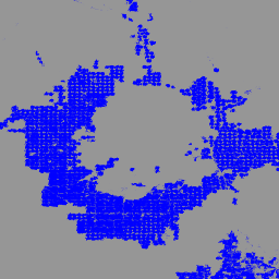
IrrMapper to coroczna klasyfikacja stanu nawadniania w 11 stanach zachodnich Stanów Zjednoczonych przeprowadzana w skali Landsat (czyli 30 m) przy użyciu algorytmu Random Forest w latach 1986–obecnie.
W artykule o IrrMapperze opisano klasyfikację 4 rodzajów obszarów (nawadniane, suche, nieuprawiane i podmokłe), ale zbiór danych został przekształcony w klasyfikację binarną, w której wyróżniono obszary nawadniane i nienawadniane.
„Nawadniane” oznacza wykrycie nawadniania w ciągu roku. Model lasu losowego IrrMapper został wytrenowany na podstawie obszernej geoprzestrzennej bazy danych pokrycia terenu z każdej z 4 klas obszarów nawadnianych i nienawadnianych, w tym ponad 50 tys. pól nawadnianych zweryfikowanych przez weryfikatorów, 38 tys. pól suchych i ponad 500 tys. kilometrów kwadratowych nieużytków.
W przypadku wersji 1.2 znacznie rozszerzono oryginalne dane treningowe, utworzono model RF dla każdego stanu oraz przeprowadzono dokładniejszą analizę walidacji i niepewności. Zapoznaj się z dodatkiem do naszej publikacji na temat wpływu nawadniania na przepływ wody w strumieniach.
Pasma
Pasma
Rozmiar piksela: 30 m (wszystkie pasma)
| Nazwa | Rozmiar piksela | Opis |
|---|---|---|
classification |
30 metrów | Nawadniane piksele mają wartość 1, a pozostałe są zamaskowane. |
Warunki korzystania z usługi
Warunki korzystania z usługi
Cytowanie
Ketchum, D.; Jencso, K.; Maneta, M.P.; Melton, F.; Jones, M.O.; Huntington, J. IrrMapper: A Machine Learning Approach for High Resolution Mapping of Irrigated Agriculture Across the Western U.S. (IrrMapper: podejście oparte na uczeniu maszynowym do mapowania w wysokiej rozdzielczości rolnictwa nawadnianego w zachodnich Stanach Zjednoczonych), Remote Sens. 2020, 12, 2328. doi:10.3390/rs12142328
Ketchum, D., Hoylman, Z.H., Huntington, J. i in. Irrigation intensification impacts sustainability of streamflow in the Western United States. Commun Earth Environ 4, 479 (2023). doi:10.1038/s43247-023-01152-2
Odkrywaj za pomocą Earth Engine
Edytor kodu (JavaScript)
var dataset = ee.ImageCollection('UMT/Climate/IrrMapper_RF/v1_2');
var irr = dataset.filterDate('2023-01-01', '2023-12-31').mosaic();

var visualization = {
  min: 0.0,
  max: 1.0,
  palette: ['blue']
};
Map.addLayer(irr, visualization, 'IrrMapper 2023');
Map.setCenter(-112.516, 45.262, 10);