Dane geoprzestrzenne ONZ to globalny zbiór danych geoprzestrzennych ONZ.
Dane geograficzne ONZ są udostępniane w celu ułatwienia przygotowywania materiałów kartograficznych w ONZ. Zawierają geometrię, atrybuty i etykiety, które ułatwiają odpowiednie przedstawianie i nazywanie obiektów geograficznych na potrzeby przygotowywania map zgodnie z zasadami i praktykami ONZ.
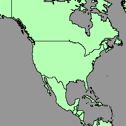
Zbiór danych geoprzestrzennych zawiera wielokąty/obszary krajów (BNDA_simplified). Więcej informacji znajdziesz na tej stronie.
Schemat tabeli
Schemat tabeli
Nazwa
Typ
Opis
admiso
CIĄG ZNAKÓW
Kod ISO-3166 alfa-3 administratora obszaru.
geo_cd
PRZ
Kod regionu geograficznego UN M49
georeg
CIĄG ZNAKÓW
Region geograficzny UN M49
globalid
CIĄG ZNAKÓW
GlobalID
globalid_1
CIĄG ZNAKÓW
GlobalID_1
int_cd
CIĄG ZNAKÓW
Kod regionu pośredniego ONZ M49; 0, jeśli nie jest ustawiony
intreg
CIĄG ZNAKÓW
Region pośredni UN M49; puste, jeśli „int_cd” ma wartość 0
iso2cd
CIĄG ZNAKÓW
Kod ISO-3166 alfa-2
iso3cd
CIĄG ZNAKÓW
Kod ISO-3166 alfa-3
lbl_en
CIĄG ZNAKÓW
Etykieta kartograficzna (angielski)
lbl_fr
CIĄG ZNAKÓW
Etykieta kartograficzna (francuska)
m49_cd
CIĄG ZNAKÓW
Kod kraju lub obszaru UN M49
nam_en
CIĄG ZNAKÓW
Nazwa (angielski)
name_fr
CIĄG ZNAKÓW
Nazwa (francuski)
objectid
CIĄG ZNAKÓW
Wewnętrzny identyfikator obiektu
st_area_sh
LICZBA ZMIENNOPRZECINKOWA O PODWÓJNEJ PRECYZJI
Całkowita powierzchnia geometrii
stscod
PRZ
Kod stanu suwerenności:
0: Antarktyda
1. Stan
2. Okupowane Terytorium Palestyńskie
3. Terytorium niesamodzielne
4. Terytorium
5. Region specjalny lub prowincja
99. Nieokreślony
sub_cd
PRZ
Kod podregionu ONZ M49
subreg
CIĄG ZNAKÓW
Podregion UN M49
Warunki korzystania z usługi
UN Geodata to globalna baza danych geoprzestrzennych dostępna dla Sekretariatu ONZ i użytkowników zewnętrznych. Można go używać do różnych celów, ale zabronione jest wykorzystywanie go w celach komercyjnych. ONZ zachowuje własność danych, a użytkownicy muszą podawać ONZ jako źródło w swoich materiałach. Dane są udostępniane „w stanie, w jakim są”, bez gwarancji, a ONZ nie ponosi odpowiedzialności za szkody ani straty wynikające z ich wykorzystania. Więcej informacji znajdziesz na tej stronie.
Dane geoprzestrzenne ONZ to globalny zbiór danych geoprzestrzennych ONZ. Dane geoprzestrzenne ONZ są udostępniane w celu ułatwienia przygotowywania materiałów kartograficznych w ONZ. Zawierają geometrię, atrybuty i etykiety, które ułatwiają odpowiednie przedstawianie i nazywanie obiektów geograficznych na potrzeby…
[null,null,[],[[["\u003cp\u003eThe UN Geodata dataset provides worldwide geospatial data, including country boundaries, for cartographic purposes.\u003c/p\u003e\n"],["\u003cp\u003eThe dataset includes geometry, attributes, and labels for depicting and naming geographic features according to UN policies.\u003c/p\u003e\n"],["\u003cp\u003eThis dataset is available for non-commercial use with proper attribution to the UN; detailed terms of use are provided.\u003c/p\u003e\n"],["\u003cp\u003eUsers can explore the dataset through Google Earth Engine, which offers tools for analysis and visualization.\u003c/p\u003e\n"],["\u003cp\u003eThe data schema includes information such as country codes, names in English and French, geographic regions, and sovereignty status.\u003c/p\u003e\n"]]],["The United Nations Geospatial Data (Geodata) dataset, provided by the United Nations Geospatial, is available from February 11-12, 2023. It includes global geospatial data with polygons/areas of countries (BNDA_simplified), geometry, attributes, and labels for map creation. The dataset, accessible via Google Earth Engine, has a defined table schema, includes ISO, M49 and GlobalID codes, and is free for research, education, and nonprofit use, but commercial use is prohibited. The UN must be credited as the data source.\n"],null,["# United Nations Geospatial Data: BNDA_simplified\n\nDataset Availability\n: 2023-02-11T00:00:00Z--2023-02-12T00:00:00Z\n\nDataset Provider\n:\n\n\n [United Nations Geospatial](https://geoportal.un.org/arcgis/home/user.html?user=United_Nations_Geospatial)\n\nTags\n:\n[borders](/earth-engine/datasets/tags/borders) [countries](/earth-engine/datasets/tags/countries) [infrastructure-boundaries](/earth-engine/datasets/tags/infrastructure-boundaries) [table](/earth-engine/datasets/tags/table) \n\n#### Description\n\nThe United Nations Geospatial Data, or Geodata, is a worldwide geospatial\ndataset of the United Nations.\n\nThe United Nations Geodata is provided to facilitate the preparation of\ncartographic materials in the United Nations includes geometry, attributes\nand labels to facilitate the adequate depiction and naming of geographic\nfeatures for the preparation of maps in accordance with United Nations\npolicies and practices.\n\nThe geospatial dataset include polygons/areas of countries\n(BNDA_simplified). Please refer this [page](https://geoportal.un.org/arcgis/home/item.html?id=e4ee80edac9d4e08b8303522dd4a5fc1)\nfor more information.\n\n### Table Schema\n\n**Table Schema**\n\n| Name | Type | Description |\n|------------|--------|---------------------------------------------------------------------------------------------------------------------------------------------------------------------------------------------|\n| admiso | STRING | ISO-3166 alpha-3 code of the area's administrator. |\n| geo_cd | INT | UN M49 geographical region code |\n| georeg | STRING | UN M49 geographic region |\n| globalid | STRING | GlobalID |\n| globalid_1 | STRING | GlobalID_1 |\n| int_cd | STRING | UN M49 intermediary region code; 0 if unset |\n| intreg | STRING | UN M49 intermediary region; empty if \"int_cd\" is 0 |\n| iso2cd | STRING | ISO-3166 alpha-2 code |\n| iso3cd | STRING | ISO-3166 alpha-3 code |\n| lbl_en | STRING | Cartographic label (English) |\n| lbl_fr | STRING | Cartographic label (French) |\n| m49_cd | STRING | UN M49 country or area code |\n| nam_en | STRING | Name (English) |\n| name_fr | STRING | Name (French) |\n| objectid | STRING | Internal object ID number |\n| st_area_sh | DOUBLE | Total area of the geometry |\n| stscod | INT | Sovereignty status code: - 0: Antarctica - 1: State - 2: Occupied Palestinian Territory - 3: Non-Self Governing Territory - 4: Territory - 5: Special Region or Province - 99: Undetermined |\n| sub_cd | INT | UN M49 sub-region code |\n| subreg | STRING | UN M49 sub-region |\n\n### Terms of Use\n\n**Terms of Use**\n\nThe UN Geodata is a global geospatial database available for use by the UN\nSecretariat and external users. It can be used for various purposes, but\ncommercial use is prohibited. The UN retains ownership of the data, and\nusers must credit the UN as the source in their creations. The data is\nprovided \"as is\" without warranties, and the UN is not liable for any\ndamages or losses arising from its use. Please refer this\n[page](https://developers.google.com/earth-engine/datasets/papers/BNDA_terms_of_use.pdf)\nfor more information.\n| **Note:** Users of the Data that are not subject to the administrative instruction (\"Outside Users\") may only use the Data for the purpose for which the Data is suitable, as identified by the Geospatial Information Section upon transmission of or granting access to the Data. Intellectual property over the Data shall at all times vest with the United Nations. Intellectual property over the products created using the Data shall vest with the Outside User. The United Nations shall be recognized as the source of the Data in any products created by Outside Users using the Data, unless the Outside Users alter the Data or combine the Data with other data sets. In case of doubt regarding crediting the United Nations as the Data source, please contact: geospatial@un.org. Outside Users acknowledge that any right to access and use the Data is revocable and non-transferable. Under no circumstances may the Data be used for commercial purposes.\n\n### Explore with Earth Engine\n\n| **Important:** Earth Engine is a platform for petabyte-scale scientific analysis and visualization of geospatial datasets, both for public benefit and for business and government users. Earth Engine is free to use for research, education, and nonprofit use. To get started, please [register for Earth Engine access.](https://console.cloud.google.com/earth-engine)\n\n### Code Editor (JavaScript)\n\n```javascript\nvar dataset = ee.FeatureCollection('UN/Geodata/BNDA_simplified/current');\n\nvar styleParams = {\n fillColor: 'b5ffb4',\n color: '00909F',\n width: 1.0,\n};\n\ndataset = dataset.style(styleParams);\nMap.centerObject(dataset);\nMap.addLayer(dataset, {}, 'BNDA simplified');\n```\n[Open in Code Editor](https://code.earthengine.google.com/?scriptPath=Examples:Datasets/UN/UN_Geodata_BNDA_simplified_current) \n[United Nations Geospatial Data: BNDA_simplified](/earth-engine/datasets/catalog/UN_Geodata_BNDA_simplified_current) \nThe United Nations Geospatial Data, or Geodata, is a worldwide geospatial dataset of the United Nations. The United Nations Geodata is provided to facilitate the preparation of cartographic materials in the United Nations includes geometry, attributes and labels to facilitate the adequate depiction and naming of geographic features for the ... \nUN/Geodata/BNDA_simplified/current, borders,countries,infrastructure-boundaries,table \n2023-02-11T00:00:00Z/2023-02-12T00:00:00Z \n-90 -180 90 180 \nGoogle Earth Engine \nhttps://developers.google.com/earth-engine/datasets\n\n- [](https://doi.org/https://geoportal.un.org/arcgis/home/user.html?user=United_Nations_Geospatial)\n- [](https://doi.org/https://developers.google.com/earth-engine/datasets/catalog/UN_Geodata_BNDA_simplified_current)"]]